Outlook – 30 April 2009

A few more days of the southwesterly flow over the Southern Plains is expected.  Today, another (small) MCS affected Oklahoma, although this time more centered on the northeast part of the state.  This has laid several boundaries (blue) across central and northern Oklahoma.  In addition, there is ample moisture; for the first time this spring, central Oklahoma dewpoints are in the upper 60s, and CAPEs are progged to be well over 4000 J/kg this afternoon.  A dryline is entering SW OK (brown) and a cold front (dark blue) is sagging into NW OK.

The SPC DY1 outlook has the area in a SLGT with a 5% tornado contour.  With the huge instability, there is also a hatched (> 2″) hail probability.

Since Central OK is outlooked, our plan is to run a PAR IOP.  If storms enter the CASA domain, we will split one forecaster into a CASA IOP as well.  An LMA IOP will not be run today, as the LMA network went down last night, and is not expected to return online until early next week.  Prior to the start of the evening IOP, we will run the forecasters through a PAR archive case.

Greg Stumpf (EWP Weekly Coordinator, 27 Apr – 1 May 2009)

Tags: None

Summary – 29 April 2009

The forecasters began the day by evaluating the 10 Feb 2009 case using the Lightning Mapping Array (LMA).  Some comments included:  coupling the data with the more-familiar NLDN (cloud-to-ground data) help with the analysis; rapid-update of data helped with updraft identification versus just 88D data; the units were difficult to understand (flashes/km^2/s); Observed the “dipole effect” on some of the storms; saw potential value for convective winter precipitation, aviation interests, and transitions from severe to heavy rain.

For the evening IOP, we worked a pretty active event in the southeast Texas Panhandle just east of Lubbock today evaluating the multi-radar/sensor algorithms and issuing experimental warnings using AWIPS.  There were a number of supercell storms, one which produced several significant tornadoes.  Large hail and damaging winds were also reported, including a nice example of a left-moving storm which created a hail swath who’s movement was contrary to the rest of the day’s storms.
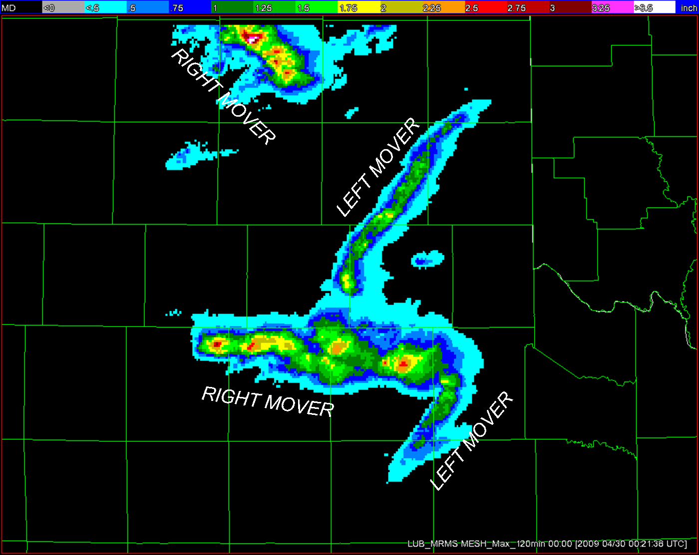
Figure 1.  MESH tracks, with left and right moving storms annotated.

Once again, the multi-radar MESH and MESH swaths were very useful for diagnosing the severity and for the orientation of the warning polygon cones, which appeared more “storm-based” than the official NWS warning polygons.  The forecasters felt more comfortable with the MRMS products today since they already had a day of experience with them, and felt their lead times were improved.  Noted that the MESH estimates on the left-mover were about 50% of the reported hail size – this same observation has also been made by the NSSL researchers.  The other hail diagnostic parameters appeared to indicate smaller hail than was observed with the left-mover.  There was a recommendation to be able to overlay the MRMS data as contours over the base single-radar data.
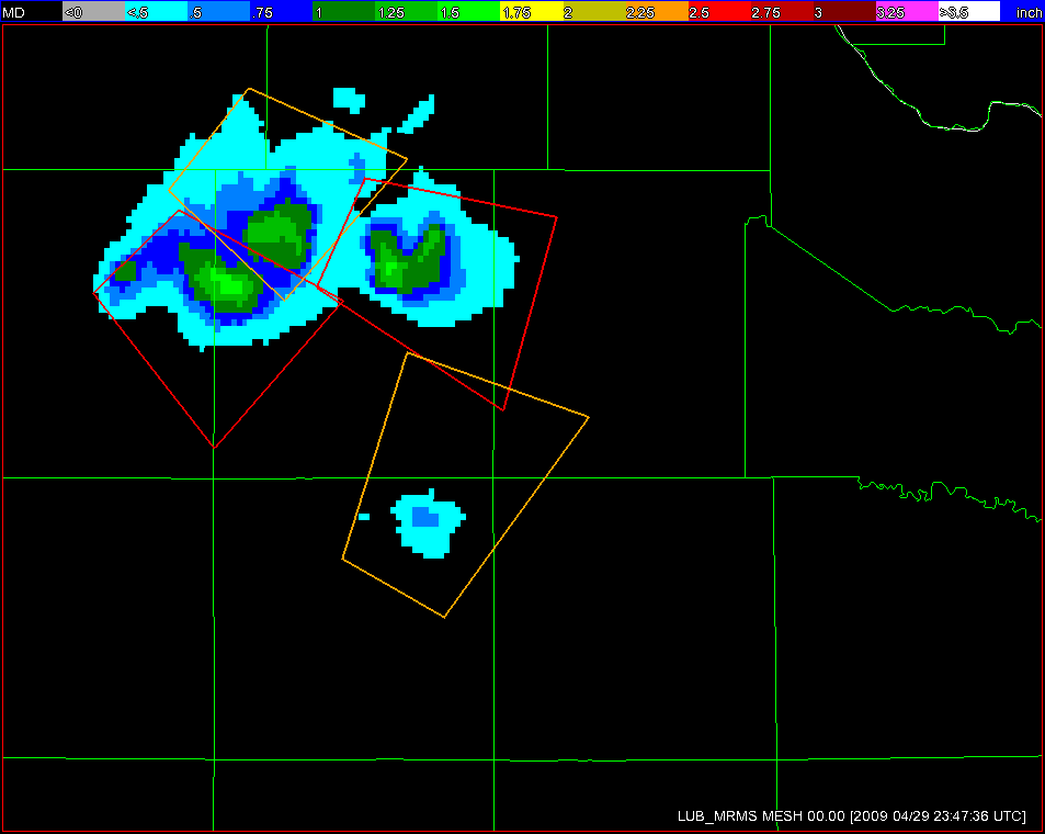
FIgure 2a.  EWP-generated warning polygons.
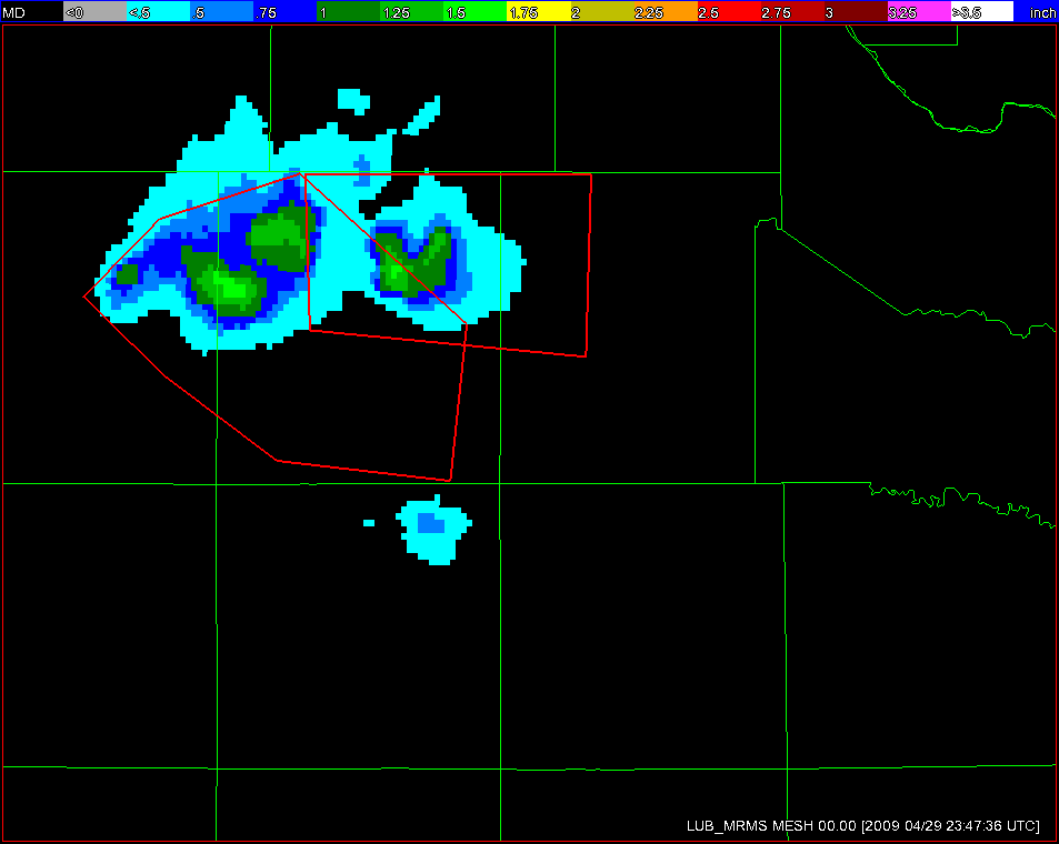
FIgure 2b.  NWS-generated warning polygons.

The rotation tracks products were also useful for the diagnosis of the tornado potential, and they also aided in the placement of the polygon cones, however a lack of “threshold guidance” was mentioned.  Something like the WDTB Tornado Warning Guidance statistics for the LLSD algorithms should be considered.  It was again commented that anticyclonic rotation tracks for the left-moving storms would be useful.  In addition, “mouse-over” trends, as well as time-height trends of the MR azimuthal shear products could be useful.

Greg Stumpf (EWP Weekly Coordinator, 27 Apr – 1 May 2009)

Tags: None

Live Blog – 29 April 2009 (8:00 pm) – wrap-up

Wrapped up around 8pm, with brief discussion and survey.   Major comments were (again) that the MESH tracks were very ueful in helping orient the warning polygons that they issued.  The Motley county (lead supercell) had a stronger signature than the one that actually produced a tornado to its west.  AzShear values were above .024 for the non-producing storm while the others were about half of that.

Forecaster favorite products this evening were:

  • MESH
  • MESH history
  • height of 50 dBZ above -20C
  • Rotation
  • Rotation History

Greg Stumpf (EWP Weekly Coordinator, 27 Apr – 1 May 2009)

Tags: None

Live Blog – 29 April 2009 (6:57 pm)

Working on one machine, now.  Forecasters alternated dinner breaks, and warning ops continue unbroken.  Live video showing a broad rain-free base on the storm of interest in Floyd / Motley counties.

Greg Stumpf (EWP Weekly Coordinator, 27 Apr – 1 May 2009)

Tags: None

Live Blog – 29 April 2009 (6:16 pm)

Both forecasters have commented independently that there needs to be a way to overlay the radial velocity from a single radar with the Rotation Tracks product.  (This is possible in WDSSII’s wg display, but is a limitation of AWIPS).

MESH values seem to match very well with reports,  except for one baseball reports that may have been associated with a left-mover.

Greg Stumpf (EWP Weekly Coordinator, 27 Apr – 1 May 2009)

Tags: None

Live Blog – 29 April 2009 (5:37 pm)

Strong convergent anti-cyclonic circulation on a storm (need anti-cyclonic rotation tracks!)

MESH of 1 inch produced 1 inch hail report.  Forecasters are using Rotation Tracks (ML and LL), MESH tracks, and Height of 50 dBZ above -20C fields extensively along side single-radar data.

Greg Stumpf (EWP Weekly Coordinator, 27 Apr – 1 May 2009)

Tags: None