Live Blog – 18 May 2010 (8:30pm)

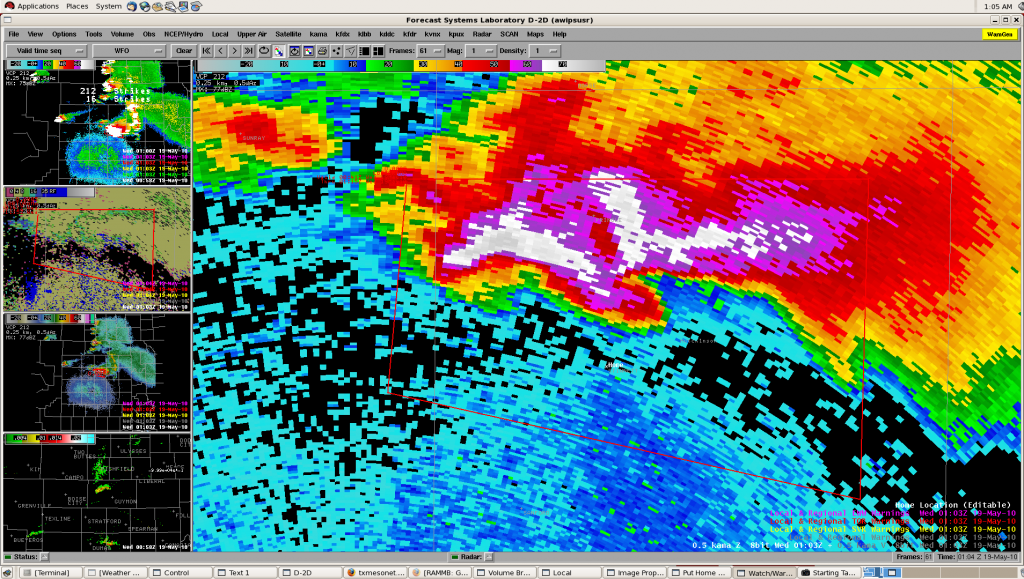
Group 1.  Amarillo CWA.  TOR warning continues near Stinnett, TX (see image below).  Including both mesos and hail area. SVR warning continues for storm in Dallam county in NW TX.  Examining velocity data, AzShear products and TX mesonet while preparing possible TOR warning for storm.

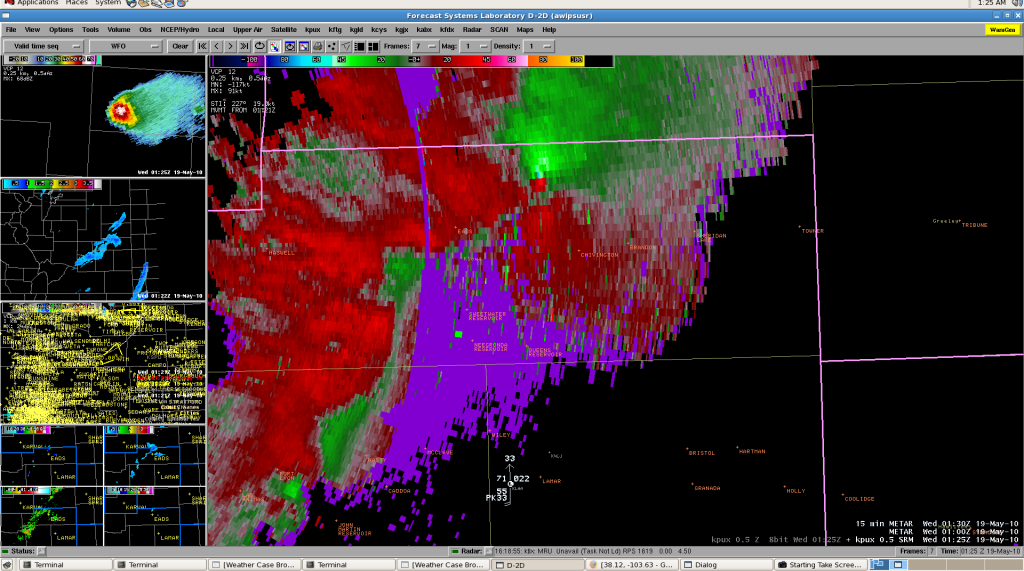
Group 2.   Pueblo. Maintaing 4 separate SVR warnings across CWA. Examining circulation in velocity data in Kiowa County with spotter reported funnel cloud.  TOR quickly issued with increased signature (below).  After TOR issuance spotters soon report tornado on the ground.   Difficult to determine strength of Las Animas storm further south due to distance from the radar and MRMS products slow to update w2hwt2.

Kristin Kuhlman (GOES-R/PGLM Principle Scientist)

Tags: None

Live Blog – 18 May 2010 (7:15pm)

Group 1:  Both AWIPS (D2D) machines are currently having technical issues.  Higgins “drag-me-to-storm” jumps randomly with storm track disappearing and products on Tupelo are not appearing completely (only as mouse over).  No memory or CPU issues on either machine.    Due to technical issues TOR warning for Moore/Hutchinson Counties at 7:15 CDT was delayed.  (Using primarily ref/velocity data combined with azshear and reflectivity at -20C  with MESH/POSH for hail)

Kristin Kuhlman (GOES-R/PGLM Principle Scientist)

Tags: None

Live Blog – 18 May 2010 (6:50pm)

Group 1:  Amarillo Region.  Tornado Warning Continues for Moore county with tornado reported E of Dumas along Hwy 152 from Vortex2 Probe7. AzShear and Rotation track products tracking well with storm w/noted increase as storm entered the City of Dumas.

SVR warning for left-mover in Cimarron County, OK.  Fast moving storm, expecting lower values form MESH/POSH in left mover after split.  Note, anticyclonic rotation with storm as well.

Group 2:  Watching Development of new cells. Two ongoing severe warnings, believe northern warning might be a bit marginal.  Southern warning includes multiple cells developing linear structure.  Continue use of MESH product (merged AzShear product a bit noisy).

Kristin Kuhlman (GOES-R/PGLM Principle Scientist)
Tags: None

Live Blog – 18 May 2010 (5:55pm)

Group 1:  Amarillo.  Tornado Warning for meso continues and severe warning for rest of storm for baseball size hail.  Vortex2 (DOW) reports brief tornado, other mobile mesonets report funnel clouds with storm. Concerned as southern storm merges into main supercell.  As storm continues to take right turn, will only maintain tornado warning for storm and let severe expire.   0-2 km azmuthal shear product tracking well with TOR warning.  Comparing to storms depicted by HRRR and NSSL/WRF from lunchtime briefing.

Group 2:  Pueblo.  Anticipated hail size growth (to quarters) based on trend reflectivity structure to issue warning; MESH hail size matched expected growth and provided forecaster confidence to SVR warning.  First issuance of tornado warning in Crowley and Kiowa counties, using primarily velocity data combined with reflectivity structure.

Kristin Kuhlman (GOES-R/PGLM Principle Scientist)
Tags: None

Live Blog – 18 May 2010 (5:00pm)

Group 2:  Pueblo CWA.  Interrogating two storms.  Were unable to use CI products as problems existed with cirrus shield and technical problems (AWIPS) delayed start of operations until after convection initiation.  Also dealing with data latency for overshooting top product.

Storm (1):  NE Crowley County.  Products used:   all-tilts, MESH, 50 dBZ core height, 50 dBZ at -20 C.  No warning at this time, though possible soon.  Also, keeping an eye of rotation track product for future use.  Examining overshooting top product, but difficult to interpret storm relationship due to parallax offset.

Storm (2):  SE Pueblo County.  Larger core, somewhat multicellular appearance and less strong aloft than storm (1).   (Using similar products as w/storm (1)).  Warning unlikely at current time.

Kristin Kuhlman (GOES-R/PGLM Principle Scientist)
Tags: None

Live Blog – 18 May 2010 (4:50pm)

Group 1:  Amarillo CWA.  Cirrus shield inhibited use of Convective Initiation products across the area.

Current radar scanning strategy not considered the best for ongoing convection.   Ongoing discussion of warning for hail and mark-up of warning; interrogating reflectivity at -10 C and MESH, POSH: 35% values.   [machine (Higgins) is slow to respond to data loading]

Kristin Kuhlman (GOES-R/PGLM Principle Scientist)

Tags: None

Outlook – 18 May 2010

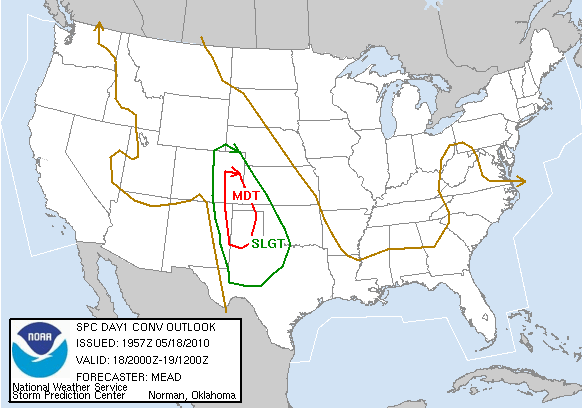
SPC has issued a Moderate Risk for SE Colorado and the TX/OK panhandles.   HRRR is indicating early initiation in SE CO and a later show in SW KS and the panhandles.

Other notes from the discussion:

  • 2345 and 0015 are GOES-R gaps (0015 is calibration, 2345 is full-disk, which happens every three hours).   Otherwise the data come in every 15 minutes.  0Z is a bad time to start looking at CI products
  • Due to lots of cirrus over the area, the CI products may not see too much use today.  However, expect GOES to operate in rapid-scan mode due to the Moderate Risk.

Travis Smith (EWP Weekly Coordinator, 17-21 May 2010)

Tags: None

Daily Summary – 17 May 2010

Most of Monday 17 May 2010 was spent on training and familiarization of the new products.  A practice IOP was conducted for one hour for the Midland/Odessa, TX (MAF) forecast office, and one practice warning was issued.

Greg Stumpf (EWP2010 Operations Coordinator)

Tags: None

Live Blog – 17 May 2010 (9:00pm)

Tonight is a practice IOP.  Several AWIPS technical issues need to be worked out, but forecasters were able to view all the data sources.  Darren and David are working with the GOES-R personnel, while Ken and Matt are issuing warnings based on MR/MS and base data in AWIPS.   IOP began at 730pm and ended at 830pm.

Very good discussion on the way forecasters issue warnings ensured.  Details to follow.

Travis Smith (EWP Weekly Coordinator, 17-21 May 2010)

Tags: None

Outlook – 17 May 2010

Today we start week 6 of the 2010 EWP.  Our visitors are David Blanchard (Flagstaff, AZ), Matt Kramar (Sterling, VA), Ken Pomeroy (Western Region HQ, Salt Lake City, UT), and Darren Van Cleave (Rapid City, SD).

First day of operations for MR/MS and GOES-R today.  We will be focusing on the area primarily large hail threat in SE New Mexico (the same area that Vortex2 is operating today).  MUCAPE is estimated at 4000 J/kg in that area, with upslope flow and 25 kts at 500 mb and a boundary providing a small chance of tornadoes as well (2% on SPC outlook).

Briefings and training will take up the afternoon, and a short IOP will start at 6:30 today.

Day 1 probabilistic hail outlook

Travis Smith (EWP Weekly Coordinator, 17-21 May 2010)

Tags: None