3DVAR: the good and the bad in Wichita, KS

As one might expect the output from the 3DVAR data assimilation is only as good as the radar data that goes into it.  This was seen clearly with tonight’s storms near the Wichita radar (KICT).

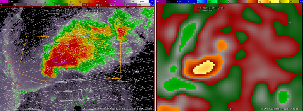
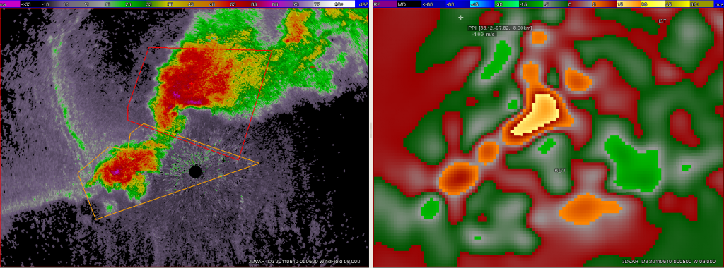
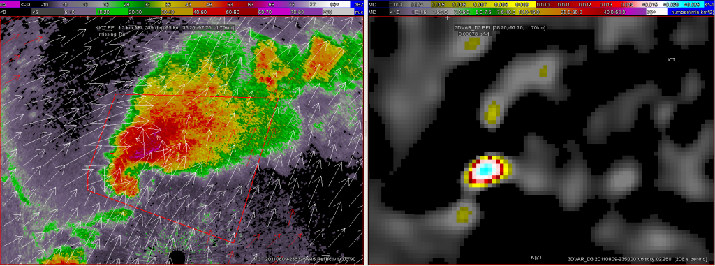
Below are displays of both the vorticity (at 2.25km) and vertical velocity (at 8km) at 2345 UTC.  At this time, the storm was just to the north of KICT and was well-sampled by the radar including good data from the inflow region as well.

KICT and 3DVAR derived vorticity
9 June 2011 2345 UTC KICT reflectivity and 3DVAR derived vorticity
KICT and 3dvar vertical velocity
9 June 2011 2345 UTC KICT reflectivity and vertical velocity from 3DVAR data assimilation

However, just 20 min later at 0005 UTC, the 3DVAR vertical velocity field developed a suspicious updraft southeast of the radar and the storm cluster:

KICT reflectivity and 3dvar W
KICT reflectivity and 3DVAR vertical velocity at 0005 UTC on 10 June 2011

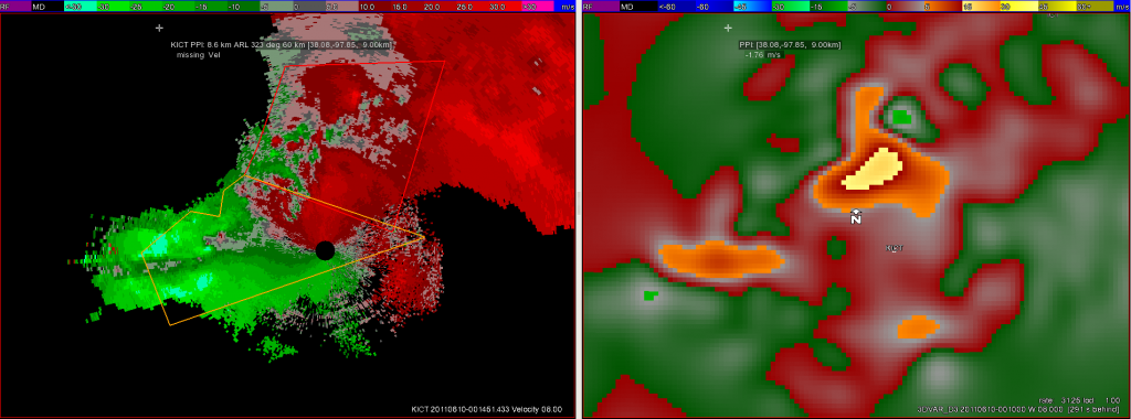
The reason for this updraft may actually have been side-lobe contamination due to anvil spread SE over the radar.  Velocity data from KICT shows this area of suspect data — the signal was continuous in both height (through almost all tilts) and time (for about 15 min).  The below image is just one example from this time:

KICT velocity and 3dvar W
KICT velocity from 8 deg elevation and 3DVAR vertical velocity field at 0010 UTC on 10 June 2011

The solution for the velocity data lead to convergence in the area and a false updraft.

Unfortunately, the output from data assimilation is only as good as the radar data brought in and this specific type error is extremely hard for even the best quality control algorithms to remove…

-Kristin Kuhlman (3DVAR scientist week 4)

Tags: None

Update: 2011-06-09 2355 UTC

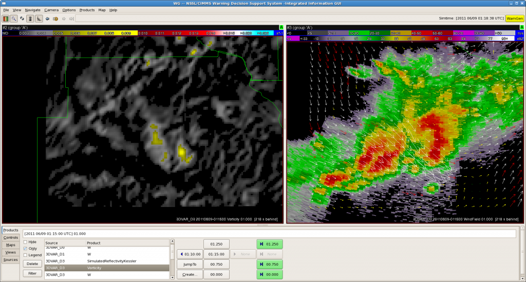
This was somewhat unexpected – a very well-formed classic supercell has developed just north of ICT.  Here are various images:

3DVAR and KICT reflectivity
Derived reflectivity from 3DVAR and KICT reflectivity with 3DVAR windfield overlaid at 2345 UTC
3DVAR vertical velocity and KICT reflectivity
Vertical Velocity field from 3DVAR data assimilation and KICT reflectivity with 3DVAR windfield overlaid

Tornado reported near Colwich KS!!!

Tags: None

Update: 2011-06-09 2340 UTC

Our early shift participants (Chris #1 and Chris #2) have broken off warnings to fill out their surveys, and Bill and Justin have taken over the NYC WFO (OKX) as the squall line moves over Long Island Sound.  It will soon be offshore, and at 6pm, we are planning to take a dinner break and move our domain to Oklahoma to watch the high-based storms and monitor OUN WRF, PGLM, and 3DVAR products.

The 3DVAR products, particularly the updraft products, seemed to underperform today.  Not worthy of an image on the blog.

Greg Stumpf, EWP2011 Week 4 Coordinator

Tags: None

Update: 2011-06-09 2100 UTC

In other news…the SPC just issued a blue box for western Oklahoma.  Since this is in our LMA domain, and OUN WRF, we may consider moving our operations to there.  More later….

Greg Stumpf, EWP2011 Week 4 Coordinator

Tags: None

Update: 2011-06-09 2150 UTC

Tech woes are slowly resolving.  The 3DVAR issues are fixed for now, although our domain is a bit too small to capture the breadth of the severe weather event.  AWIPS issues on higgins are causing problems with warning issuance.  We discovered that the Boston warning headers are ‘BOX’ and need to be manually changed to ‘BOS’.  In addition, the warning VTEC counters are not incrementing with each new warning, so we’ll need to edit these manually.

So, what is going on weatherwise?  We have a line of severe storms moving through southern New England and southeast New York, with a few stray severe cells out ahead of the line.  And we just got a report of 1.75″ hail from Wappingers Falls, NY, my home town!  The event looks like this right now (Reflectivity at -20C):

Greg Stumpf, EWP2011 Week 4 Cooridinator

Tags: None

Update: 2011-06-09 1950 UTC

We started early today, as severe convection is ongoing in New England and Eastern New York State.  However, our systems decided to finish the experiment a day early.  We are in the process of relocalizing AWIPS and restarting radars and the ingest, as well as fixing some 3DVAR issues right now.  One team is working the Boston CWA, and the other started out as Albany, but have now moved to New York City CWA.  More soon….

Tags: None

2011-06-09: Area Forecast Discussion

Cold front…analyzed at 17z from northern NY…to northwest Ohio will continue to move southeast through the afternoon hours. Convection is currently developing fairly across northwest VT to near Binghamton. Expect continued new convective development along the boundary towards the southwest…as forcing along the boundary quickly overwhelms limited CINH.
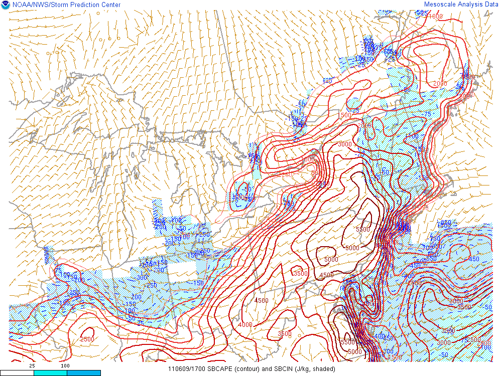
Observations of UAH CI products and CIMMS cloud top cooling products has confirmed the rapid nature of convective development.

Objectively analyzed instability fields indicates moderate to extreme surface based energy exists ahead of the cold front…with an axis of 4000+ j/kg from just west of PHL to west of ALB. Forecast soundings ahead of the boundary suggest damaging wind gusts are the primary…and most widespread…severe weather threat.

Convection ahead of cold front is expected to exit New England by 2300z which may require shifting the area of interest farther to the west later in the operations period.

Frontal boundary becomes stationary…and more poorly defined westward across the western Ohio valley….to the central plains…as several areas of convectively induced outflow adds complexity to subjective analysis. Much of the area near the front/outflow boundaries through the Ohio valley will likely continue to be active with strong/severe storms through the afternoon and evening. A series of weak waves moving through the region may result in some modulation in the activity. Interest also points to portions of eastern KS… IA and northern half of MO… depending on exact location of boundaries and the front by late afternoon. Adequate deep layer shear would support a few supercells.

Farther southwest in OK…
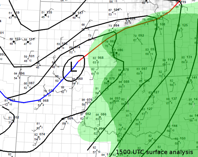
The 15 UTC surface analysis shows a 1005 low south of Dodge City, KS,
and a frontal zone extending from near Kansas City to the low center
toward the SW into the Texas panhandle. A 30-35 kt Sly low level jet
is located over W Texas into W Kansas per RUC analysis. A zone of
elevated convection stretches from NE Kansas into N-central and SW
Oklahoma. East of the front, surface dew points are in the mid 60’s
over much of central and E OK, and the upper 50’s and low 60’s in W
Oklahoma. Within the warm air mass steep lapse rates are present in
the 800-500 hPa layer. A thermal axis at 850 hPa more or less
collocated with the zone of elevated convection is associated with a
rather robust cap that will probably require lift in addition to
diurnal heating in order to be broken.

Model guidance suggests that CAPE should rise a little bit to ~2000
J/kg across most of C & E OK, E KS during the day, but there is
consensus among RUC/NAM and GFS that the boundary layer will tend to
dry out during the day, as a result of vertical mixing and northward
advection of drier air, analysed over north-central Texas. A shortwave
trough over E Colorado will move E/NE ward, but most forcing
associated with this feature should pass into Kansas.

GFS, RUC and NAM produce little to no precip over OK until 00 UTC
strong CAP. HRRR has a little bit of precipitation developing around
21 to 22 UTC in several runs.  Yet, a few storms will probably form
over W Oklahoma in vicinity of the front, probably in the late
afternoon or early evening (22-02 UTC). Somewhat higher coverage is
expected across Kansas. Given that 0-6 wind shear increases to about
40 kt, well-organized multicells and perhaps one or two rotating
storms will be possible. The few storms that develop will probably
produce some large hail, and, given the deep dry boundary layer, some
severe wind gusts.

Buonanno/Sohl/Groenemeijer
Tags: None

Update: 2011-06-09 0120 UTC

We are done warning for the night and beginning discussion and surveys.  First discussion is on the storms NW of DVN.  The gust front moved out ahead of the refl cores, and this is visible on the 3DVAR wind vectors as well.

Greg Stumpf, EWP2011 Week4 Coordinator

Tags: None

Update: 2011-06-09 0040 UTC

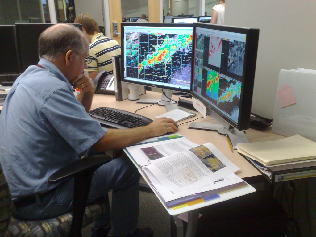
Our participants hard at work issuing warnings, using 3DVAR and MRMS experimental data:

Fig 1.  Chris B. issuing warnings as MKE (Milwaukee) while 3DVAR scientist David Dowell, and student intern Alex, observe.

Fig. 2.  Chris S. issuing warnings as DVN (Davenport IA).

Greg Stumpf, EWP2011 Week4 Coordinator

Tags: None

Update: 2011-06-09 0005 UTC

Weak rotational couplets are now being observed on the storms in MKE’s area in SW Wisconsin.  Interstngly, they are better observed from KDVN radar, but in a typical WFO setup, Milwaukee couldn’t look at KDVN level II data, unless they used an alternate source (like GR2AE).  But in the HWT, our MKE forecaster can just walk over to the DVN forecaster and look at their level II data.  Here is the storm relative velocity data in question:

Fig 1.  KDVN Velocity data.

Fig 2.  KMKX velocity data.

Greg Stumpf, EWP2011 Week4 Coordinator


Tags: None