UAH CI shows new convection developing over eastern Dona Ana county and expect continued development through 1930Z. EM and other decision makers should continue to monitor this area for possible warnings and statement.
8 May 2012: Outlook
Looks like we are operating in S and SW Texas again. The upper level flow and shear remains best under the sub-tropical jet, and ample moisture remains in place. Unfortunately, there is no cap in the south Texas area, and convection is already ongoing, with some embedded severe, in that area. Shear is adequate for severe, and a small chance of tornadoes. But there is a lot of current convection owing to the weak cap. And there is a chance for storms to move out of Old Mexico across the Rio Grande. Nevertheless, we are going to have one team operate as Brownsville (BRO) and the MRMS and 3DVAR domains will be available to them over that area. We have a contingency to also add Corpus Christie (CRP) as well if needed.
A second area of convection, with CI just beginning, is over far west Texas and southern New Mexico, as well as adjacent Old Mexico. Moisture is mre lacking in that area, so the main threat will be microbursts. We will have our second team operating as the El Paso, TX (EPZ) office and look primarily at the nowcast and CI products only, since this is too far west to include in the MRMS domain.
Here is the SPC DAY1 outlook for comparison:
Greg Stumpf, EWP2012 Week#1 Coordinator
Daily Summary – 7 May 2012
Our first day for EWP2012 so our teams operating an MCS with embedded severe cells in the San Angelo, TX, (SJT) and Austin/San Antonio, TX (KEWX) WFOs. The storms were moderately severe with low coverage. Mostly 1-1.75″ hail, a few wind damage reports, and one tornado report near Llano, TX. Our teams issued a few SVR warnings, as they were adapting to the new experimental products.
Greg Stumpf, EWP2012 Week #1 Coordinator
EWX Meso Update 2320Z UTC
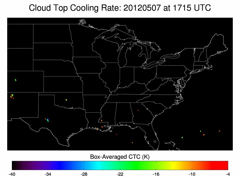
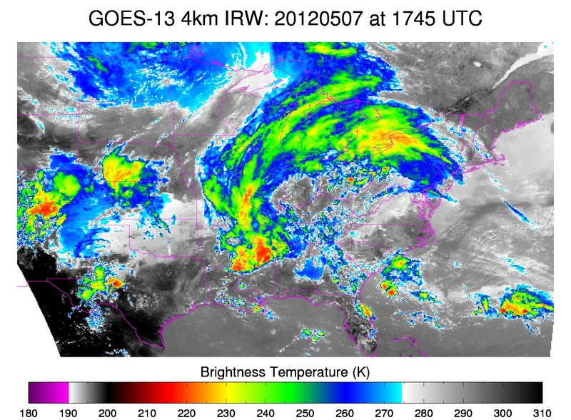
The first image below shows cloud top cooling rates at 1715Z. Note the values of almost -35 K in the light blue over west central TX. The second image below of IR satellite imagery at 1745Z, depicts the beginning phases of strong convection in the same region as the cloud top cooling noted 30 min before strong convection initiated. The CIMSS cloud top cooling product correctly predicted the formation of a complex of strong storms that later became severe during the late afternoon/early evening hours.
RB/AMS
SJT Crockett Co Update @ 23Z
NWS SJT was monitoring two areas of thunderstorms. the strongest storms were located immediately west of Crockett Co., moving north and being influenced the westbound outflow boundary from earlier convection. Max Composite Updrafts were showing 15-17 m/s though inconsistently. These storms are capable of producing 1-1 1/2 inch hail according to the MESH algorithm. Though the strongest updrafts and threat of severe hail were located west of Crockett county, we will continue to monitor this complex for the potential warnings in the near future.
The second area of storms were in central Crockett county and does not appear to be a threat. Brief heavy rain will be the primary impact.
Nunez
EWX Meso Update 2230ZUTC
Issued a warning on a cell for hail and wind based on radar trends and the fact that this storm was moving into a good environment. The above image of radar reflectivity shows the storm moving southeast into a good theta-e environment depicted by the yellow axis on the above image. The theta-e imagery is CIMSS-NRE Layer GOES Vertical Theta-e Diff Low-Mid Img
RB/AMS
SJT Crockett Co. update
SJT thoughts @ 2200Z
Thunderstorm anvil was masking the new development upstream so the CI/CTC products were not registering data. The Max Updraft Composite definitely proved to be useful with the new development over Mason Co. and anticipated the collapsing updrafts over San Saba Co. where 1″ hail was detected with 10 minutes lead time. Nunez
SJT: Mason Co. Storm Update @ 2145Z
Storm development was increasing rapidly across northeast Mason Co. Max Composite Updraft values ranged between 19-21 m/s-1 during the last 10 minutes. Warning is likely for this area. Nunez


