Convection continues in Montana

hailstonewr

Storms are still festering in the NW BYZ CWA. This one near Hailstone Wildlife Refuge (okay, its name was a big factor for this post) went from 12% to 36% between 0046z and 0048z.

Lightning trends have not been impressive – only the northern storm, just outside the radar screenshot, has had a thunderstorm alert.

NWCWAENI

Jason Williams

Tags: None

ENI Data with Storm Split

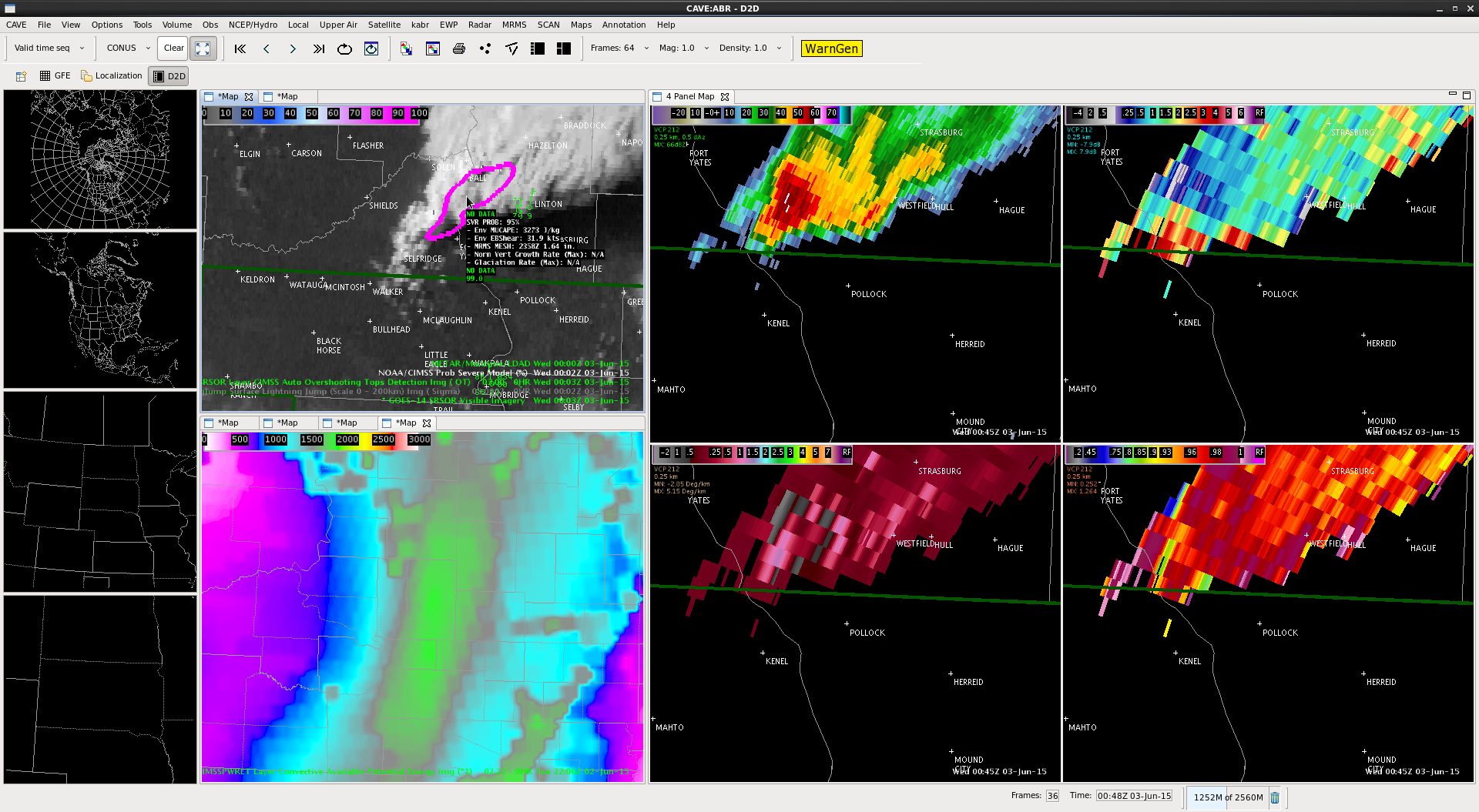
This was an interesting case where the storm split and the ENI data highlighted the stronger southern cell which was very beneficial in the warning process.

The ENI products all worked beautifully in this case. Initially, I noticed a slowly increasing trend in Prob Severe around 2346Z over the cell. By 2355Z, I noticed that there was an ENI DTA Thunderstorm Alert on the storm. At 0000Z, the ENI DTA Thunderstorm Alert increased to Significant and the Prob Severe split into two ovals since the storms had split by this point. By 0007Z, I  began to see that the southern storm had become the stronger of the two cells as the severe prob had increased to 72% while the northern storm prob severe was only at 42%. At 009Z, prob severe on the southern cell increased to 90% while it was still only 42% on the northern cell. At this point, I decided to go ahead and pull the trigger on the severe thunderstorm warning for the southern cell. Knowing that the prob severe was much lower on the northern cell increased my confidence that I should only include the southern cell in my warning polygon. The warning took a long time to get out due to some technical difficulties, so I didn’t get the lead time that I would have liked, but the warnings did verify. There was a report of 1.25” hail at 7:25 PM, 2” hail at 7:23 PM and 1” hail at 7:52 PM.

ENISplit(Click image to animate)

The ENI time series data was also helpful in this case as it showed lightning jumps around the same time I was seeing other signs of intensification. This increased my confidence that the storms were indeed intensifying and that a severe thunderstorm warning was needed.

ENIstormsplit

-Helen Hunt

Tags: None

ProbSevere and Best Practices

I think ProbSevere has usefulness even after the storms initiate and even after they become severe.  SCAN allows us to see the environmental read out around a cell, however the probsevere’s displays allows me to easily see the important information about the environment.  i like this better than the scan display.

Screenshot-CAVE:ABR - D2D

MacGyver

Tags: None

Storm exiting BYZ CWA still impressive

ENI_plot_0023z
Hail reports ended being sub-severe, but it was good that there was finally confirmation that something was happening with the storm exiting the SE corner of the BYZ CWA. Radar was becoming increasingly difficult to use due to distance from radar, but the lightning data continued to show it maintaining its strength and perhaps even intensifying after 00z. This may sound a lot like my previous post, but I’m really impressed with how helpful this was on this particular storm. It’s worth reiterating that this product may have a lot of value when dealing with storms at a great distance from the radar site.

Jason Williams

Tags: None

Using ProbSevere as a key piece of info for warning decision.

Issued a SVR at 23:53z over northern Stutsman County. Lightning flash rate increased prior to intensification from 2340Z to 2347Z (fig 1) then the cell produced 55 dbZ to >30kft.  The cell was getting to be far from the radar with the 0.5 scan reaching only 12.5kft. ProbSevere showed probability of 94% at this time (Fig 2).  The limited low level information with a farther distance from the radar made the use of ProbSevere more heavily weighted in the warning decision. –CattyWampus

flashplot

Fig 1: Increasing flash rate from 2340Z to 2347Z.

2352zProb

Fig 2: ProbSevere 94% at 2352z.


Tags: None

Environmental Analysis of ABR


Using the data provided to compare the instability between the NUCAPS, RAP and Satellite derived CAPE.  It appears that the NUCAPS and RAP are similar in their forecast values.  The NUCAPS can serve as a check of the RAP.  In this case, they look pretty good.

Tags: None

Utilizing 1 min GOES Visible Satellite Imagery

Utilizing the 1 min GOES visible satellite imagery, I was able to detect a very distinct outflow boundary extending from Stark County into Grant County. The 1 min imagery was helpful in predicting the evolution of storms. I could see the cumulus growing along the outflow boundary and see it propagating southeastward. I assumed that the convection would continue to develop and be focused in the area where the outflow boundary was merging with the southern extent of the storm in Morton County.

VIS1min

(Click on the image to see animation)

-Helen Hunt

Tags: None

No-warn using ENI and ProbSevere in Montana

ENI_plot_2331z 2324z_radar

ProbSevere was increasing after 2300z, and reached above 80% at the 2324z radar scan. However, the lightning data doesn’t show anything particularly notable as far as an increase in rate.

Hail potential is evident on radar, although ProbSevere MESH is only at about 1″. Given the marginal nature of the MESH and the lack of increase in lightning, this is a situation in which I would hedge toward not warning because of the addition of the experimental products. If I just had NEXRAD, I would have leaned toward warning, despite the distance from radar.

Jason Williams

Tags: None

Overshooting top in SRSO, no algorithm trigger, parallax error

SRSO vis channel showed an overshooting top (Fig 1: Gif Loop) in McLean Co, but the overshooting top detection algorithm did not make a detection on this feature. This was useful information in that it showed it wasn’t vigorous enough to actually be quantified as strong enough to be detected.  Also noticeable was the 1 minute lightning was displaced south of the overshooting top feature, but aligned with the radar echo. After discussion with Chris S. the displacement seems to be a result of parallax error.  –Cattywampus

parallax

Tags: None