Environmental Data

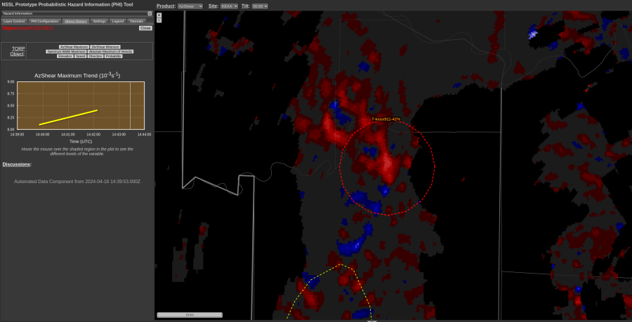
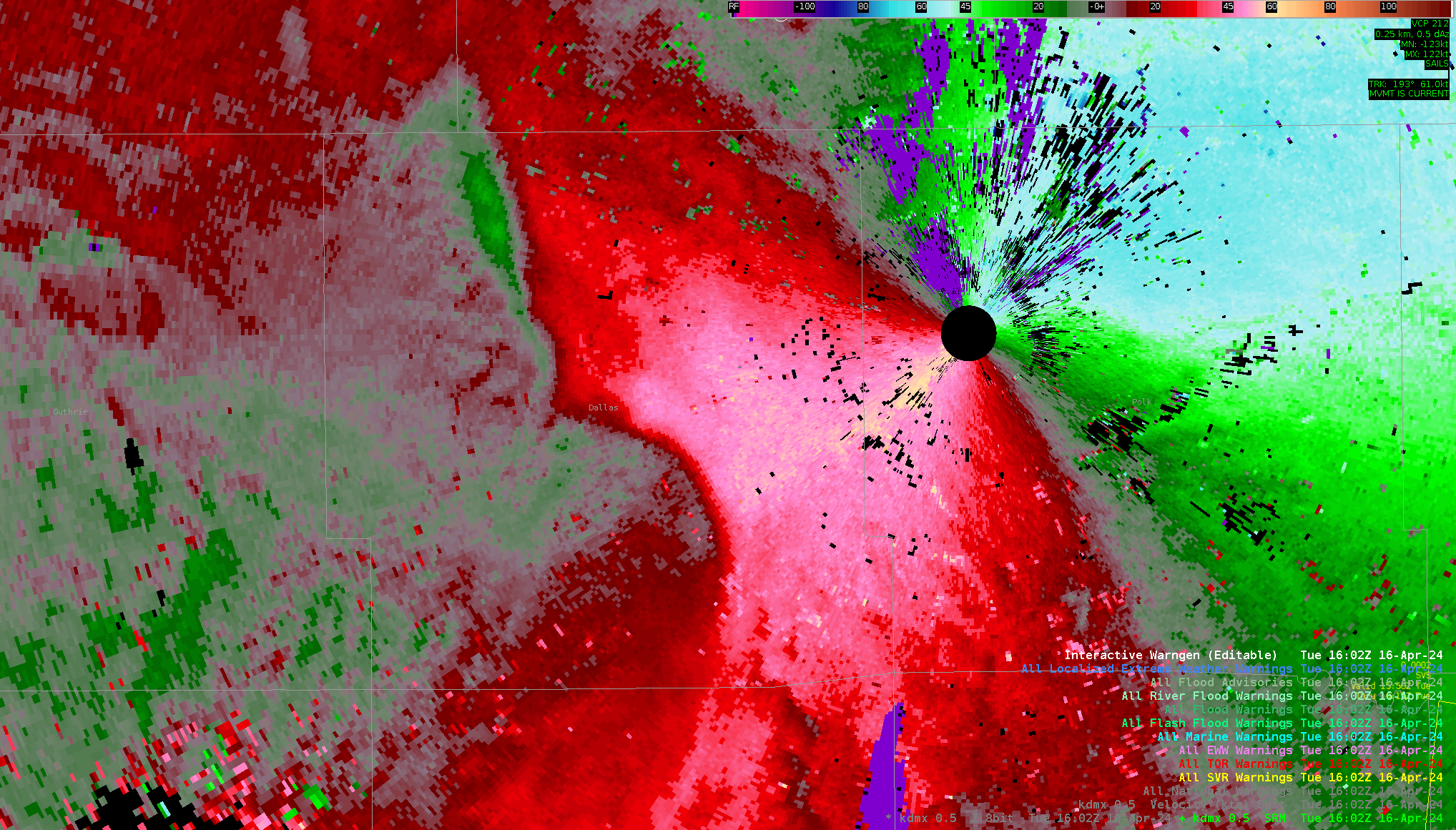
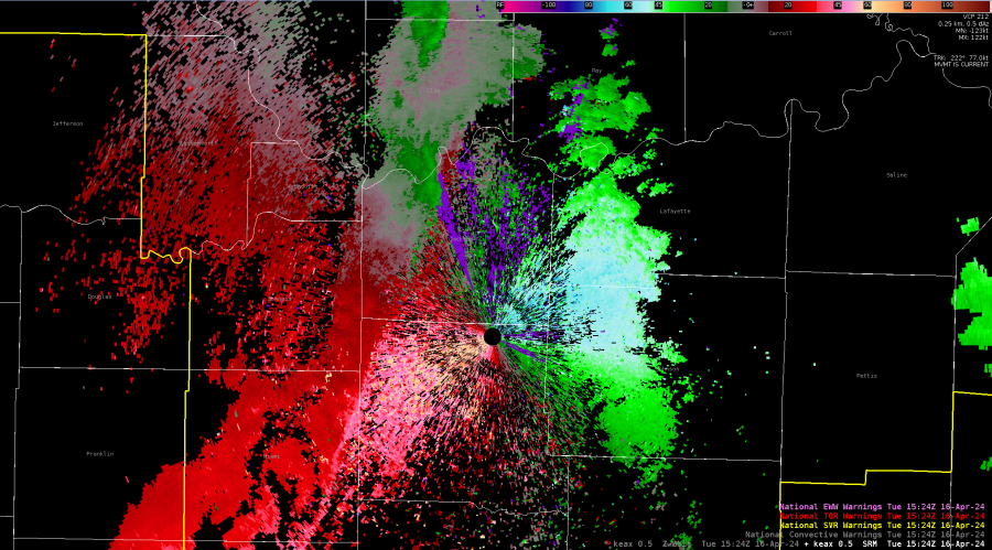
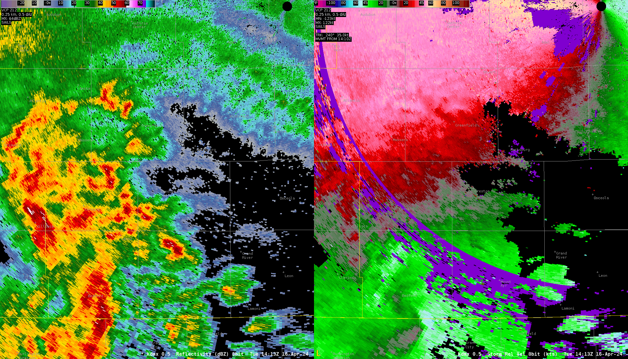
Along with radar data, near-storm environmental conditions are an integral part of the  warning decision, so including it in the TORP display would be very useful to warning forecasters.  Contoured plan view data of  MUCAPE, MLCIN, 0-1 km helicity, etc should be added to the “Weather Related Overlays” to tell if storms are moving into more/less favorable environments. Some other environmental data items that could be added to the list of graphed data trends: DCAPE, 0-6 km shear, 0-3 km helicity, Other forecasters will have their own preferences for what environmental parameters to include.

Posted by Rigel

TORP sorts out bad Az Shear couplet

Here’s an example where Az Shear was overly excited by bad Velocity data yet TORP was not tricked. Despite Max Az Shear being the highest ranked predictor for TORP, TORP did not produce an object for said area (at least above the 20% threshold I’m currently viewing). When looking at reflectivity data, clearly there is no developing mesocyclone (or really anything at all) in the Az Shear couplet’s vicinity (not to mention the velocity data is just obnoxiously extraneous).

A high Az Shear couplet (near center of photo) from false velocity data fails to trigger TORP object.
Erroneously Velocity data clearly not associated with anything meteorological from Reflectivity.

P.S. I missed a Tor while making this. Whoops!

-Wx Warlock

TORP Lead Time vs. Radar Data

A quick spin up occurred just east of the KDMX radar that was difficult to identify on velocity data alone with any amount of lead time. There was some enhancement in surface convergence at the 1604z scan, but potentially not enough to grab your attention or warrant a tornado warning. By the next scan at 1606z, there was a couplet with 30kt+ of Vrot. At the 1607z scan, there was a CC drop collocated with the couplet. It might have been difficult to get much lead time on this tornado with radar data alone. That said, the two screenshots from TORP/AzShear might have led you to issuing, or at least drawing up the warning, at the 1604z scan with the sharp jump in probability and AzShear maximum as noted on the graphs on the left. This is a good example of where the product could have gotten you a minute or two extra of lead time. -newt

Possible Tor DMX

The trend on this storm has really come up, and a rapid increase was identified. Couplet visible in SRM data as well and I would issue a tor on this storm, and probably would have a scan before based on AZ shear data – Wildcat

Outflow Boundary Vortices

There was a nice example of small vortices forming along an outflow boundary with a line of convection in the FSD county warning area around 1545Z  on 16 April. These small vortices are sometimes  associated with storm damage from  non-supercell tornadoes or “gustnadoes”. The TORP identified one of these circulations with rapid increases in both AzShear and Spectrum Width Maximum trend.

Posted by Rigel

Smoother TORP with Highly Variable Max AzShear

With a storm in close proximity (~20 miles) to the KEAX radar, AzShear had some rather large jumps in maximum values. The data was pretty noisy due to the proximity to the radar, so the rapid change in AzShear makes sense in this case.

After looking at the base velocity data, it looks like to drop off of the max AzShear had to do with range folding or bad radar data close to the radar.  When the range folding affected the couplet pasing to the NNW of the radar, AzShear dramatically dropped off in response.

TORP also displayed various jumps as well in response to the variance in AzShear, but was way more tamed than the AzShear. This is good to see that there is not as much variability in TORP even with the jumps in AzShear as AzShear is the top parameter TORP relies on. This could be confusing if TORP jumps back and forth from 20% and 60% (just throwing out numbers), so it is good to see it’s more smooth than the jumps in AzShear.

-Stormy Surge

Slow TORP Response for TOR Warning Consideration Event

From 1500-1515 UTC,  a brief increase in organization and rotational increase occurred along a broad shear zone in Clay County, Missouri. Eventually, a rather pronounced cyclonic convergence signature appeared at the north side of the convergence zone, with TOR warning consideration made. However, despite prolonged period of critical AzShear threshold values met, TORP was slower to respond, and by time values spiked towards relative maximum (~65%) for this event, the signature had abated from a base data perspective. -QLCS

Known QLCS TORP Issue spotted!

Our morning real time case has taken us to Iowa with an ongoing broken line of thunderstorms. While there have been a few signs of mesocyclonic development, I noticed a known issue with TORP object detection as a QLCS approached KDMX along the radial from the south southwest. While Az Shear was generally unimpressive with this line, the QLCS’s orientation with the radar caused a couple TORP objects to generate. While their probability values were low (near 30%), it still caught my eye as something to check out and then immediately write off after checking radar data. This hiccup wasn’t necessarily disruptive to my forecasting process, but was useful to know about before starting off today so I wouldn’t be confused when I see it.

QLCS approaches KDMX along the radial from the south southwest.
TORP creating a couple of objects along the QLCS line moving along the radial towards DMX.

-Wx Warlock

Increasing Severe Probs with Increasing Object Size

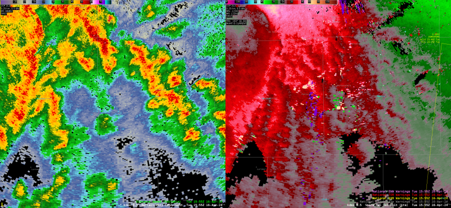
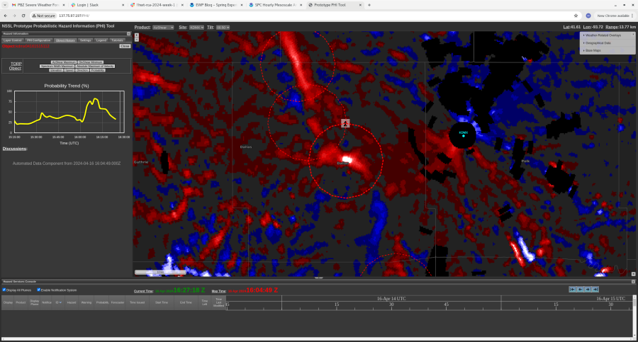
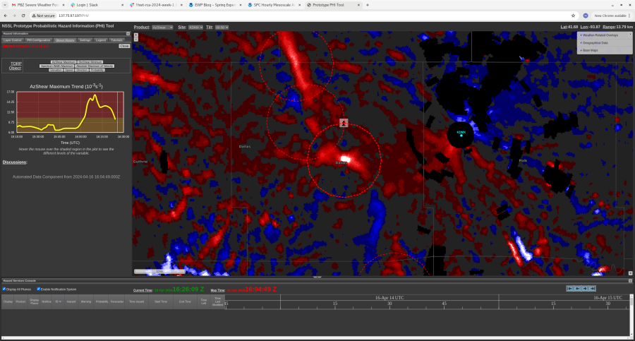
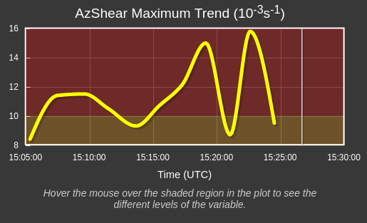
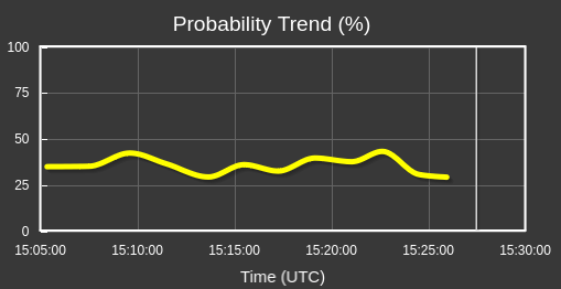
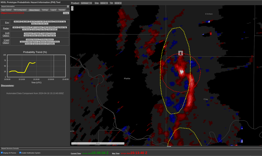
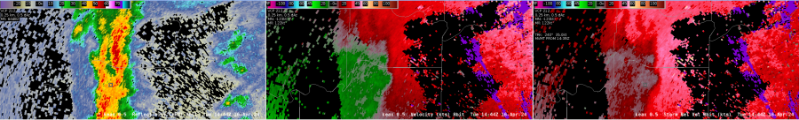
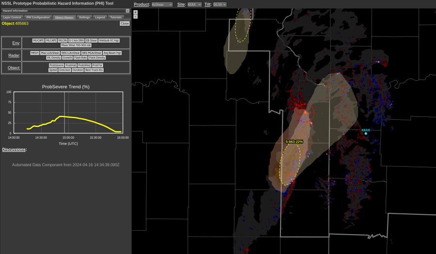
Initially, prob severe detected a small area for it’s algorithm and it tagged it with low severe probabilities. As the storm progressed, prob severe picked up a larger area for the object, and when it did that, the probabilities increased. This could indicate that the storm is gaining strength, but radar presentation has remained almost steady state. This could be a detection issue as when it picks up a larger area, the probabilities increase due to size.

-Stormy Surge

Transient TORP Object Amidst Weak Cyclonic Signature

Around 1445 UTC Tuesday, with evidence of weak cyclonic convergence from base data/KEAX (top), a TORP object (~40%) was generated. This occurred despite AzShear remaining below critical threshold. The cyclonic signature on base data/SRM weakened over subsequent scans, and the TORP object ended. In early days of the experiment, I have been using ~40% as a baseline threshold for TORP situational awareness. Will continue to assess if similar instances occur, requiring a shift in baseline TORP percentage.  -QLCS