Prob Severe and Lightning…developing storm in Midland CWA

An area of convection (70% probability in GOES CI) continued to develop around 1900 UTC.  Between 1922 and 1928 UTC, the Prob Severe increased from 18% to 63%, and by 1935 was up to 86%.  The lightning jump increased to 2 sigma during this time.  The 1 minutes lightning density increased over a 2 minute time span from 1 to about 4 flashes/gridbox.   By 1945, the lightning density was up to 9 flashes/gridbox.  All of this evidence points to convection which is increasing in intensity.LightningMLD

Evidence from the NUCAPS sounding as well as the GOES LAP CAPE suggest the storm is in an environment with around 1000 J/kg of CAPE.  By 20:06, the storm is a well-organized supercell with a hook echo and well defined rotational velocity.

MLDreflecMLDvelocity
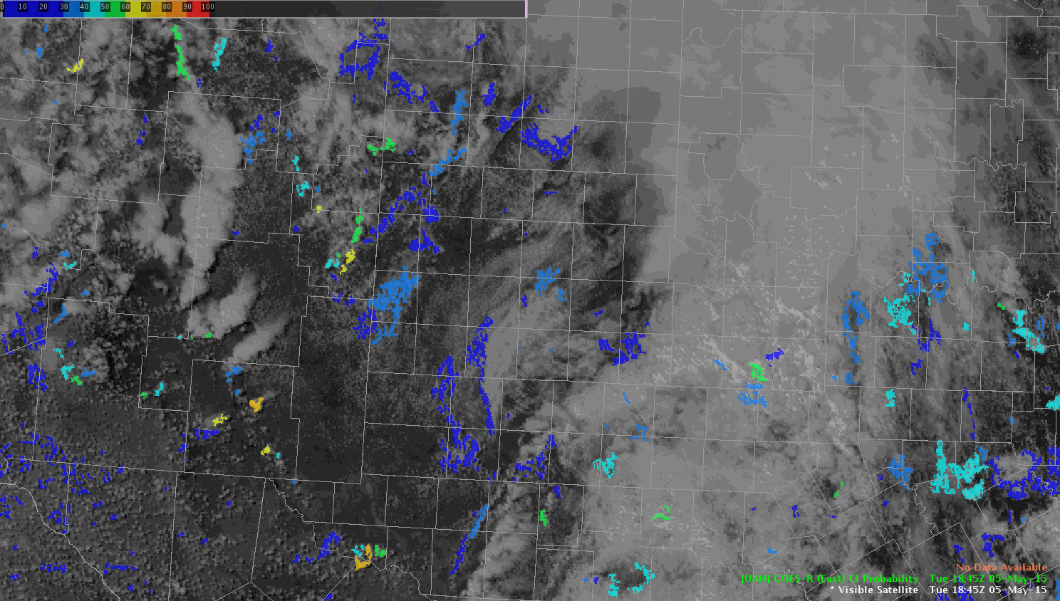
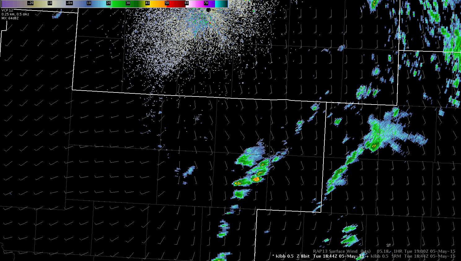
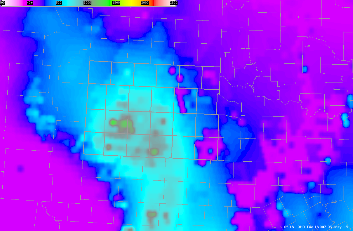
The combination of lightning data, Severe Prob, NUCAPS and GOES LAPE CAPE were good indicators of strengthening storm worth watching.  The storm produces a tornado.

Tags: None

Convective Initiation temporal resolution concern

Looking just beyond our LBB CWA to the south I noted a CI change from at 1845 UTC which showed 10% probability of convective initiation to a 70% probability at 1900 UTC.

CI_Loop
Animated loop

However, when looking back at the radar loop starting at 1845 UTC which matches the first satellite image and continuing past 1900 UTC, we can see the development of an isolated convective cell.

Radar_loop
Animated radar loop

At 1900 UTC a 39 dbz core was noted, so in this case the temporal resolution of the CI product (15 minutes) effectively resulted in a miss as the 35+ dbz was already present at the time the 70% probability was given.  This does not diminish the situational awareness value of the product.

Jack Bauer

Tags: None

Initial Setup for LBB

Today we are set up as WFO LBB in north central TX.  Water vapor imagery (upper left in image below) shows large upper low centered over the four corners region with broad cyclonic flow across NM/TX with plenty of dry air moving into the forecast area.  Visible imagery shows some general clearing across the area as thicker clouds moved out of the area from this morning.  Expect convection to develop later this afternoon as atmosphere destabilizes across the region with hail and damaging winds as the main threat. An initial look at the CI product (lower left in image below) is showing mainly low probabilities of initiation across the LBB CWA but there have been some higher probabilities to the west over NM closer to the core of the upper low where lapse rates are steeper and associated with the colder air aloft.

4pnl_WV_VIS_CI_PWLooking at the GOES-R LAP precipitable water data the significant dry air is located in the 700-300mb level (lower left in the below image) which matches up well with RAP analysis soundings.    Not much on the radar this point to look at but will be monitor for developing convection.

4pnl_GOES-R_PWJack Bauer

Tags: None

Lubbock CWA Conditions

My warning operations will focus over the Lubbock CWA this afternoon.  Clearing of this morning’s cloud cover began to occur around 1830 UTC.  A cumulus field has quickly developed in the areas which cleared.  I will be watching the GOES CI Probability in this region as instability continues to increase.  GOES LAP CAPE values through the CWA range from 500 to 8000 J/kg, with some spotty areas of up to 1100 J/kg.GOESCAPE

Tags: None

Starting Soon! 2015 Experimental Warning Program

Several experiments to improve National Weather Service severe weather warnings will be conducted this spring in the NOAA Hazardous Weather Testbed (HWT) as part of the annual Experimental Warning Program, a joint project of the National Weather Service and NSSL/CIMMS to support NOAA’s goal to evolve the National Weather Service and build a Weather-Ready Nation.The EWP’s Spring Warning Project will run from May 4 through June 12, and provides a conceptual framework and a physical space to foster collaboration between research and operations to test and evaluate emerging technologies and science.

Forecasters will evaluate an updated Lightning Jump Algorithm (LJA), based on the GOES-R Geostationary Lightning Mapper, that was enhanced based on feedback from forecasters participating in the 2014 program. In severe storms, rapid increases in lightning flash rate, or “lightning jumps,” typically precede severe weather such as tornadoes, hail, and straight line winds at the surface by tens of minutes.  These evaluations will help prepare for possible operational implementation in 2016 following the launch of GOES-R.

Earth Networks’ total lightning and total lightning derived products, including storm-based flash rates tracks, time-series, and three levels of thunderstorm alerts will be evaluated in real time, building upon the initial evaluation in 2014. The 2015 evaluation will test the feasibility of use and performance under the stress of real-time warning operations.

A new set of high-resolution Weather Research and Forecasting (WRF) models will serve as a prototype for developing the “Warn-on-Forecast” warning paradigm. Feedback from this project will go into developing new model tools capable of managing the large amounts of model information associated with future forecast systems.

During three weeks of the experiment, forecasters will assess a new tool using rapidly-updating high-resolution gridded Probabilistic Hazard Information (PHI) as the basis for next-generation severe weather warnings. This experiment is part of a broad effort to revitalize the NWS watch/warning paradigm known as Forecasting a Continuum of Environmental Threats (FACETs). The major emphasis of the HWT PHI experiment will be on initial testing of concepts related to human-computer interaction while generating short-fused high-impact Probabilistic Hazard Information for severe weather. The long-term goal of this effort is to migrate the refined concepts and methodologies that result from this experiment into Hazard Services, the next generation warning tool for the NWS, for further testing and evaluation in the HWT prior to operational deployment.

This year will mark the inaugural HWT Experiment with Emergency Managers. The EMs will be provide feedback on their interpretation of experimental probabilistic forecasts generated in the HWT from the PHI experiment and the Experimental Forecast Program (EFP). This feedback will be used in conjunction with feedback from forecasters to refine how the uncertainty information is generated and disseminated.

Prepared by Susan Cobb, NSSL

Tags: None

Starting This Monday – ENTLN Experiment (Week 6)

Monday 25 August 2014 begins the sixth and final week of our Earth Networks Total Lightning Network (ENTLN) Experiment.  This experiment is a part of the 2014 NSSL-NWS Experimental Warning Program (EWP2014).  This will conclude the 2014 experiments in the Hazardous Weather Testbed.

NOAA National Weather Service (NWS) forecasters will test how lightning data impacts the warning process during convective events in the NOAA Hazardous Weather Testbed.  In particular, they will utilize Earth Networks’ “Dangerous Thunderstorm Alerts” – which may increase forecaster situational awareness and lead times – during a series of warning scenarios in displaced real time.  These events cover the gamut of atmospheric possibilities, ranging from marginally severe to significantly tornadic, and occur over a variety of locations.   The final outcome of this project is to make recommendations on possible product improvements, and determine whether Earth Networks products should become part of the operational product suites available to NWS offices nationally.  The ENTLN Experiment will be conducted in conjunction with Earth Networks and runs from 21 July to 29 August.

For the week of 25 – 29 August, our distinguished NWS guests will be Andrew Hatzos (WFO Wilmington, OH), Jason Jordan (WFO Lubbock, TX), and Joey Picca (WFO New York, NY),  If you see these folks walking around the building, please welcome them!   The National Severe Storms Laboratory (via the Sandy Supplemental) has generously provided travel stipends for our participants.

Kristin Calhoun and Darrel Kingfield are the project coordinators.  Our support team also includes Matt ElliottTiffany MeyerDaphne LaDueLans RothfuszChris Karstens, Aaron Anderson, and Gabe Garfield.

You can learn more about the EWP here:

https://hwt.nssl.noaa.gov/

Gabe Garfield

Tags: None

Starting This Monday – ENTLN Experiment (Week 5)

Monday 18 August 2014 begins the fifth week of our Earth Networks Total Lightning Network (ENTLN) Experiment.  This experiment is a part of the 2014 NSSL-NWS Experimental Warning Program (EWP2014).

NOAA National Weather Service (NWS) forecasters will test how lightning data impacts the warning process during convective events in the NOAA Hazardous Weather Testbed.  In particular, they will utilize Earth Networks’ “Dangerous Thunderstorm Alerts” – which may increase forecaster situational awareness and lead times – during a series of warning scenarios in displaced real time.  These events cover the gamut of atmospheric possibilities, ranging from marginally severe to significantly tornadic, and occur over a variety of locations.   The final outcome of this project is to make recommendations on possible product improvements, and determine whether Earth Networks products should become part of the operational product suites available to NWS offices nationally.  The ENTLN Experiment will be conducted in conjunction with Earth Networks and runs from 21 July to 29 August.

For the week of 18 – 22 August, our distinguished NWS guests will be Stephen Hodanish (WFO Pueblo, CO), Gail Hartfield (WFO Raleigh, NC), and Nelson Vaz (WFO New York, NY),  If you see these folks walking around the building, please welcome them!   The National Severe Storms Laboratory (via the Sandy Supplemental) has generously provided travel stipends for our participants.
Kristin Calhoun and Darrel Kingfield are the project coordinators.  Our support team also includes Matt ElliottTiffany MeyerDaphne LaDueLans RothfuszChris Karstens, Aaron Anderson, and Gabe Garfield.

You can learn more about the EWP here:

https://hwt.nssl.noaa.gov/

Gabe Garfield
2014 EWP Operations Coordinator

Tags: None

Starting This Monday – ENTLN Experiment (Week 4)

Monday 11 August 2014 begins the fourth week of our Earth Networks Total Lightning Network (ENTLN) Experiment.  This experiment is a part of the 2014 NSSL-NWS Experimental Warning Program (EWP2014).

NOAA National Weather Service (NWS) forecasters will test how lightning data impacts the warning process during convective events in the NOAA Hazardous Weather Testbed.  In particular, they will utilize Earth Networks’ “Dangerous Thunderstorm Alerts” – which may increase forecaster situational awareness and lead times – during a series of warning scenarios in displaced real time.  These events cover the gamut of atmospheric possibilities, ranging from marginally severe to significantly tornadic, and occur over a variety of locations.   The final outcome of this project is to make recommendations on possible product improvements, and determine whether Earth Networks products should become part of the operational product suites available to NWS offices nationally.  The ENTLN Experiment will be conducted in conjunction with Earth Networks and runs from 21 July to 29 August.

For the week of 11 – 15 August, our distinguished NWS guests will be David Glenn (WFO Newport, NC), Alexander Gibbs (WFO Peachtree City, GA), and Jonathan Kurtz (WFO Norman, OK),  If you see these folks walking around the building, please welcome them!   The National Severe Storms Laboratory (via the Sandy Supplemental) has generously provided travel stipends for our participants.

Kristin Calhoun and Darrel Kingfield are the project coordinators.  Our support team also includes Matt ElliottTiffany MeyerDaphne LaDueLans RothfuszChris Karstens, Aaron Anderson, and Gabe Garfield.

You can learn more about the EWP here:

https://hwt.nssl.noaa.gov/

Gabe Garfield
CIMMS/NWS OUN

Tags: None

Starting This Monday – ENTLN Experiment (Week 3)

Monday 4 August 2014 begins the third week of our Earth Networks Total Lightning Network (ENTLN) Experiment.  This experiment is a part of the 2014 NSSL-NWS Experimental Warning Program (EWP2014).

NOAA National Weather Service (NWS) forecasters will test how lightning data impacts the warning process during convective events in the NOAA Hazardous Weather Testbed.  In particular, they will utilize Earth Networks’ “Dangerous Thunderstorm Alerts” – which may increase forecaster situational awareness and lead times – during a series of warning scenarios in displaced real time.  These events cover the gamut of atmospheric possibilities, ranging from marginally severe to significantly tornadic, and occur over a variety of locations.   The final outcome of this project is to make recommendations on possible product improvements, and determine whether Earth Networks products should become part of the operational product suites available to NWS offices nationally.  The ENTLN Experiment will be conducted in conjunction with Earth Networks and runs from 21 July to 29 August.

For the week of 4 – 8 August, our distinguished NWS guests will be Tom Lonka (Newport, NC),Sam Shamburger (WFO Nashville, TN), and Stephen Keighton (WFO Blacksburg, VA),  If you see these folks walking around the building, please welcome them!   The National Severe Storms Laboratory (via the Sandy Supplemental) has generously provided travel stipends for our participants.

Kristin Calhoun and Darrel Kingfield are the project coordinators.  Our support team also includes Matt ElliottTiffany MeyerDaphne LaDueLans RothfuszChris Karstens, Aaron Anderson, and Gabe Garfield.

You can learn more about the EWP here:

https://hwt.nssl.noaa.gov/

Gabe Garfield
CIMMS/NWS OUN

Tags: None