OUTLOOK: 14 June 2012

Today, were are focused on the Upper Mississippi Valley for severe convective development.  A potent, negatively-tilted shortwave trough is moving quickly across the north-central U.S.   Strong deep-layer shear associated with the trough should combine with moderate (to strong) instability and deep moisture to produce severe convection, including supercells.  It is uncertain, however, whether sufficient heating can occur in the wake of a late-morning mesoscale convective system across eastern Minnesota and western Wisconsin.  If destabilization can occur in the vicinity of the residual outflow boundary, tornadoes will be possible.

A secondary area of interest is in south-central Nebraska, where the surface front curves to the southwest.  In this area, the moisture is both deep and quality; the instability , strong to extreme; and the winds at the surface should back, augmenting — to some extent — the marginal wind shear.  That said, severe hail and winds should be the primary threats.

We will start operations in the Minneapolis (MN), Sioux Falls (SD), and Hastings (NE) county warning areas, with an eye toward the  Duluth (MN) CWA — should destabilization occur.

-G. Garfield, Week 5 Coordinator

Tags: None

EWP STATUS FOR 14 JUNE 2012: 1-9 p.m. SHIFT

EWP STATUS FOR 14 JUNE 2012: 1-9 p.m. SHIFT

On Thursday, we will begin our shift at 1 p.m.  The operational models depict a strong, negatively-tilted shortwave trough entering the Upper Midwest by early afternoon.  The associated strong deep-layer shear and moderate instability will support supercells/organized convection in Minnesota and Wisconsin during the afternoon/evening hours.   Given moderate low-level shear and low LCLs, a tornado threat may emerge as well.  However, this may be tempered by a relatively quick transition to the linear convective mode, owing to the strong forcing associated with the ejecting upper trough.  Current thinking is that the Duluth, Minneapolis, and LaCrosse county warning areas are the most likely candidates for severe operations.

– G. Garfield, Week 5 Coordinator

Tags: None

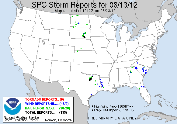
Daily Summary: 13 June 2012

Today, we started operations in the Albuquerque (NM) and Midland (TX) county warning areas.  Another early-morning mesoscale convective system left an outflow boundary over west Texas.  While the atmosphere recovered in its wake during the afternoon, storms developed in the less-capped/higher-terrain to the north.  Forecasters Tim Tinsley and Jeff Garmon monitored the experimental products in Midland, while Mike Dutter, Randy Skov, Steve Nelson, and Ty Judd split duties in the Albuquerque (ABQ) CWA.  The forecasters evaluated the CI, cloud-top-cooling, OUN WRF, and 3DVAR products.

This time, however, storms in the ABQ CWA struggled to maintain strength as they moved off the mountains.  This prompted a domain switch of the southern ABQ forecasters (Dutter and Skov) to the Sioux Falls (FSD), South Dakota CWA and the northern ABQ forecasters (Nelson and Judd) to the Fort Worth, Texas CWA (storms were ongoing in both CWAs).

Upon arrival, the FSD crew immediately issued severe warnings.  These warnings verified well, as hail up to the size of golfballs and a funnel cloud were observed in the CWA.  The FWD crew also began issuing warnings as soon as they arrived in their CWA.  By that time, two supercell thunderstorms were ongoing in the Dallas-Fort Worth Metro Area, producing hail up to the size of baseballs and one report of a funnel cloud.  Substantial hail damage occurred over the densely populated suburbs of Irving and Grand Prairie.  The 3DVAR products — as well as the OUN WRF in FWD — were interrogated during the event.

The Midland crew issued several warnings, using the OUN WRF, CI, and 3DVAR products.  No reports were received, owing the sparse population of west Texas.  The MESH in one storm, however, was up to 2.5 inches in diameter.

-G. Garfield, Week 5 Coordinator

Tags: None

OUTLOOK: 13 June 2012

Today, we are focused on two areas for severe convective development.  The first is in the southern High Plains, where rich, deep moisture resides beneath a very potent elevated mixed later.  As surface temperatures warm, strong to extreme instability is expected to develop over west Texas into eastern New Mexico.  However, kinematic profiles are marginally favorable for the development of organized convection.  Nevertheless, the degree of available potential energy suggests that this area should be watched for severe weather.

The second area is located in the central and northern Plains.  An upper-tropospheric trough is emerging onto the Plains this afternoon, and resultant pressure falls will create a kinematic environment favorable for the development of organized storms.  However, the moisture is limited and the lapse rates are only moderate where moisture quality is the greatest.  Nevertheless, we will monitor this area for convective development.

-G. Garfield, Week 5 Coordinator

Tags: None