In the HWT this Thursday, we looked at storms which erupted in Montana. The storms took a little while to erode what little cap was there, and formed by early afternoon. There was an impressive MCV centered almost right over the Glasgow radar (KGGW). In addition, there was a short wave approaching from the west, and a frontal system in place complete with a warm sector over Montana.
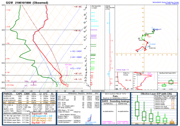
Soundings in the area (Image 1) showed impressive CAPE, DCAPE, ample speed shear, marginal low level lapse rates, and impressive mid level lapse rates. We watched GOES satellite imagery in the area and saw several cells begin to develop all at the same time more or less along the warm front. Supercells eventually developed and moved slowly to the northeast.

During and after CI we watched how ProbSevere3 responded to the increasing severe threat. Here is a screenshot of one of the storms at 2144Z along with the ProbSevere2 and 3 readouts and the ProbSevere3 time series. This cell northeast of Glasgow showed some of the highest probabilities of the week for both algorithms, including a ProbTor of 22% according to the newer algorithm, and 7% according to the older one.
These LP storms were very photogenic- according to Twitter- and went on to produce monster hail larger than baseballs as well as tornadoes. In this instance, ProbSevere3 and 2 did a great job. Since ProbSevere3 is more conservative than 2, it is worth the time for forecasters to compare the 2 algorithms side-by-side once they are both available. This will help them calibrate their thinking as to what amounts usually produce certain amounts of wind damage, hail size, and tornadic activity. For example, just working with ProbSevere3 a few days, I know that a 22% tornado probability and 57% wind threat is very high, at least for supercells in the northern Plains in June.
As convection initiated, it took ProbSevere3 a while to find an “object”, and thus assign probabilities. It is possible the dry air as well as the heights at which the radar was hitting the storms played a role in us seeing reflectivity before probabilities started to come in. In addition, lightning took a while to develop, and this is also included in the algorithm.
When the storms were just developing and while they were discrete, ProbSevere3 did seem to encircle large areas of the storms and label them as one object. This has to do with the way the algorithm defines an object, and has improved since the last version. Still, it could be confusing to have one probability for several storms. While research continues on this, it underscores the fact that forecasters must use this as a tool in the toolbox and as a confidence-booster, not as an absolute last word on the severity of storms.
-Dana Scully

