NUCAPS Sounding for NE Kansas

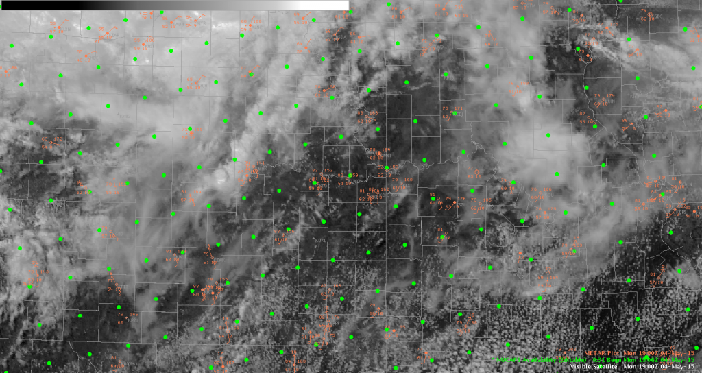
With the main convection still to the south of the area, decided to test out the 1900Z NUCAPS sounding. With clouds and convection closer to the KS/NE border, went a little farther south into Kansas for the sounding, which conveniently lined up the KFOE site.

20150504_1900Z_NUCAPS_Area

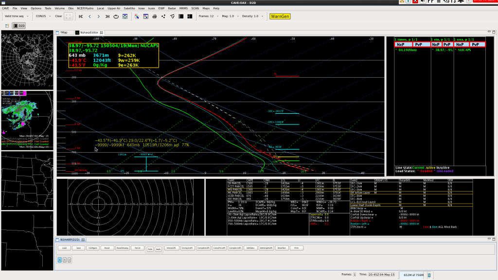
Clicking on that point came up with the sounding shown below.

20150504_1900Z_NUCAPS_Orig

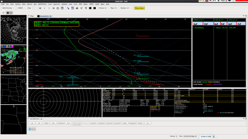
This sounding provided a good first guess, but looking at the surface data (75/56 on the sounding) indicated that it needed to be adjusted to match the ob at KFOE (84/59).

20150504_1900Z_NUCAPS_Modified

Making that adjustment to the surface conditions increased the CAPE values from around 1350 J/kg to 2660 J/kg. That put the values better in line with the initial values see on the RAP initial conditions. -SRF

Tags: None

Lightning Observations at HWT

Total lightning has a large role in the Experimental Warning Program this year.  We are on day 1 of the first week and everyone is familiarizing themselves with the various products.  I have shown an quick comparison of some of the products that we will be evaluating throughout the week.

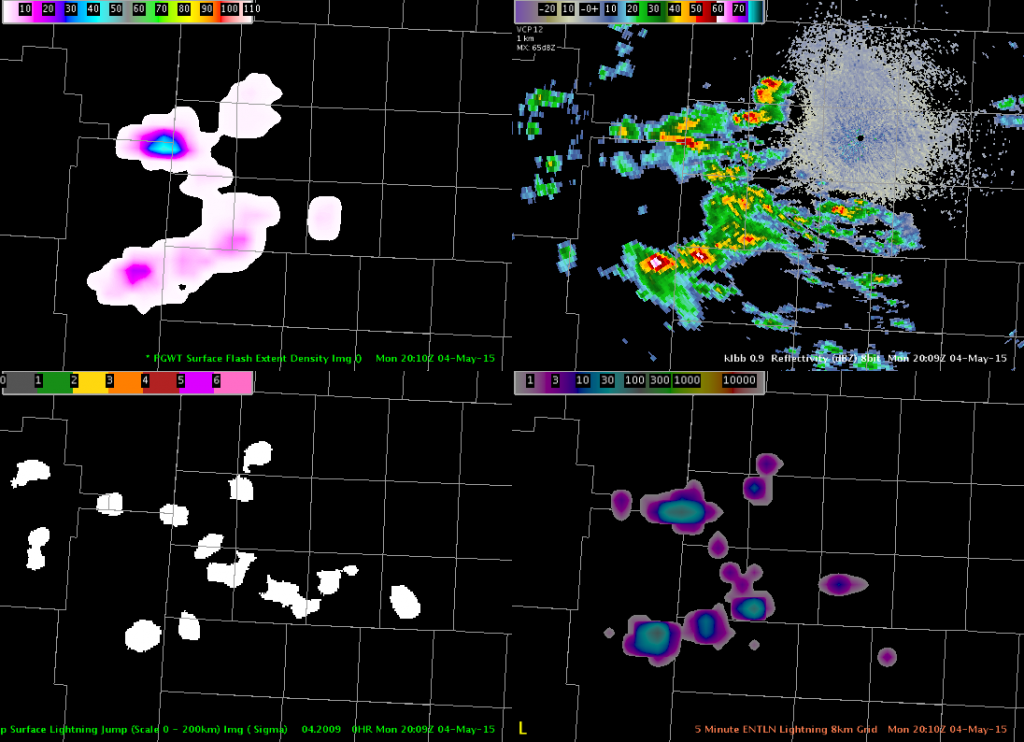
The storms cooperated by moving into the West Texas LMA domain (Lubbock county warning area) allowing for the first views of the NASA SPoRT pseud-geostationary lightning mapper (PGLM) this year.  The image shows the PGLM (upper left), radar reflectivity (upper right), the lightning jump showing the sigma level change using Earth Networks data (lower left), and the Earth Networks total lightning over a 5 min summation and put on an 8 km grid.

The PGLM is showing a maximum value of 41 flashes over a 2 min window with the Earth Networks showing ~40 flashes over a 5 min window.  The lightning jump indicated the storm in the north as having a 1-sigma change, which is not enough to indicate severe weather is imminent.  The PGLM gives another view of spatial extent of the lightning, which is particularly evident in the northernmost section.  The main advantage of Earth Networks is the coverage, unlike the small domains from the lightning mapping arrays that are used to derive the PGLM.

Lightning observations from the 2 min PGLM (upper left), radar reflectivity (upper right), lightning jump algorithm (lower left), and Earth Networks 5 min data on an 8 km grid.
Tags: None

First Severe TOP

First severe storm warning issued at 2002 UTC for a storm over northern Pottawatomie county along strong instability gradient, just southeast of a weak surface low and in the vicinity of weak surface boundary.

SVRTOP1_DTA_PROBSVR

Looking at the all-tilts products we noticed 60 dbz values above the -20C level and the ETN displayed a DTA with a significant increase in flash rate from around 30 to 60 to over 100 flashes in consecutive scans.  This coincided with GOES-R overshooting top detection as well as the lightning jump algorithm showing a 2 sigma jump followed by a 6 sigma jump.

4panel_PHI_ProbSvr_OvershootTop_LtgJump

The probability of severe increased to over 90% shortly after the warning went out and the PHI also was showing values in the 70s preceding the warning and was above 80% at the warning issuance.  This particular case in my mind really builds my confidence in the potential of the lightning jump, PHI and prob severe algorithms as it relates to warning operations and potentially improving lead time, of course after proper studies have been done in both verifying and null events.  It would be helpful to have some sort of threshold values for PHI and Prob severe as general guidance (based on geographical location).

DTA track was not very representative of the actual storm motion as it had a northern bias.  This could be due to the storm favoring the instability gradient and local boundary as the actual storm motion was more east of the DTA track.

Jack Bauer/Brick Tamland

Tags: None

Awips 2 issue with Cell Tracking

Overlayed cell tracking with Thunderstorm alert Level 2 and Alert Level 3 on KMAF reflectivity. Also had points (editable). I wanted to get the cell lightning trend. However, number of cell flashes per minute was not displayed and clicking on the point had no response.

Tiffany reloaded all of these images and then was able to successfully get a graph of lightning trends. Cell tracking and Alerts with points

-Lynford

Tags: None

AMA is Lighting Up

The excitement at the moment is in the Texas Panhandle. A quick look at one of the cells in Amarillo’s CWA:

AMA lightning jump

(note: this is LBB radar data as we’re not pulling in AMA data at the moment)

The ENI Lightning Jump algorithm shows a 2 sigma jump. The contours are the NOAA/CIMSS highly experimental probability severe, coming it at 47%.

AMA prob svr
It had peaked slightly earlier around 60%.

19Z temp and moisture profiles from JPSS came in just after 20Z. I picked a point sounding in the relatively clear area of the eastern OK Panhandle…

AMA VIS_NUCAPS

And the resulting temp/dewpoint profile:

AMA NUCAPS sounding

Surface based CAPE was 1016 J/kg with an LI of -4C. This is comparable to the approx 1100 J/kg and -5C shown on the GOES-R LAP algorithm in this area at 19Z.

AMA Svr

WFO AMA ended up issuing a severe thunderstorm warning for this storm. Now we wait for verification.

-V. Darkbloom

Tags: None

Lightning Jump Leading Rapid Intensification

With convection largely staying south of the OAX area, have been watching convection in the TOP area. Saw a really good use of the Lightning Jump Detection Algorithm showing a rapid increase in lighting with the cell in northeast Kansas. At 1941Z, the cell was fairly weak with modest lightning.

20150504_1941Z_OAXRadar_LightningJumprobSevere

As the initial cell weakened and a second cell developed to the east the lightning diminished and then rapidly increased at 1951Z producing a significant lightning jump (6 sigma).

20150504_1951Z_OAXRadar_LightningJumpProbSevere

The ProbSevere product was trailing at this time due to the rapid increase (<5%), but within 15 minutes it rapidly increased to over 90% at 2005Z.

20150504_2005Z_OAXRadar_LightningJumpProbSevere

While I wasn’t looking closely at the radar data while producing a previous blog post, that rapid increase shown in the lightning jump algorithm really caught my attention and showed me that it was something to checkout. -SRF

Tags: None

Overlaying Radar with Lightning Jump

To tie in with a previous post of overlaying two image products (and adjusting the transparency), I tried that out with the OAX radar and the Lightning Jump product.

On its own, the color table for the lightning jump makes the jumps stand out really well but unfortunately it covers up the radar data.

20150504_1940Z_OAXRadar_LightningJump_NoTrans

By adjusting the transparency (70% on Lightning Jump), I found the combined use of the two products to be much more useful.

20150504_1940Z_OAXRadar_LightningJump

Unfortunately with the colors in the current table, they become washed out at time with the greens and yellows.  While it isn’t as big of an issue with smaller cells (first image below), but when the convection is more widespread (bottom image from west Texas) it makes it harder to see with the colortable.

20150504_1950Z_OAXRadar_LightningJump

20150504_1948Z_TexasRadar_LightningJump

-SRF

Tags: None

Day 1 Initial Set-up

Well, the first post of day 1 and I have to admit I feel a bit overwhelmed with the amount of information and data to look at as we are supposed to look at all the available experimental products as we assess the environment for the day and also build procedures for the rest of the week.  I think I will feel a bit more comfortable when we are focused a bit more and looking at specific products within the warning operations environment.

WaterVapor

Initial look at the big picture shows a deep trough over the desert southwest with somewhat diffluent flow across the southern plains with downstream ridging over the Mississippi Valley.

Radar_obs

A surface frontal boundary was noted across north central KS with possible weak low lifting northeastward through southeast NE.  Some weak convergence resulting in developing convection across northeast KS as of 19z.  Best instability at 19z based on the GOES-R LAP algorithm was centered over western OK into southern KS and expanding into the southern part of Topeka’s Forecast Area, which seemed reasonable when compared to the RAP13 analysis at 19z.  There has been little if any lightning in the convection over northeast KS to this point so have not evaluated the lightning data too much.

ConvectInitiation

An initial look at the convection initiation algorithm off the GOES-R over northeast KS did not reveal much with generally less than 20 % initiation values leading up to the convection that has developed.  There is a fairly dense layer of cirrus overhead which is likely obscuring the ability of the GOES-R to detect and leading to the low percentages, which is a limiting factor of this product.

Jack Bauer

Tags: None

Visible Satellite with Overlay of GOES-R LAP CAPE

Being a person that likes overlaying multiple images, I found overlaying the Visible Satellite with the GOES-R LAP CAPE product (transparency of 50%) to be useful in situational awareness. Putting the data into a loop provided an easy way to view the increasing instability over eastern Kansas under clear skies and where dewpoints were rising from the upper 50s to the lower 60s. -SRF  Note: It looks like you need to click on the image to see the loop.

20150504_1900Z_VisAndLAPCAPE

Tags: None