
 With a -10C level around 17.7 kft, there should be lightning, at least in-cloud, with this storm. It has had a sustained core of 40+ dBZ above 18 kft for successive volume scans, however the lightning flash products are not showing anything.
-KP
Official websites use .gov
A
.gov website belongs to an official government
organization in the United States.
Secure .gov websites use HTTPS
A
lock (
) or https:// means you’ve safely connected to
the .gov website. Share sensitive information only on official,
secure websites.

With a -10C level around 17.7 kft, there should be lightning, at least in-cloud, with this storm. It has had a sustained core of 40+ dBZ above 18 kft for successive volume scans, however the lightning flash products are not showing anything.
-KP
![]() While this tool is fun to play with…I’m not sure it tells me anything I can’t already see. However, watching the trends of multiple storms against one another is nice. This product would be most useful for well behaved (non-deviant) mature storms where less user input in required for accurate output. Not sure how the graphs on the right work, as a new one appears each time a new meteogram is added, but there are duplicates. I suppose that if you load a product with more variables, i.e. KDP, CC, etc., there may be less duplication and more valuable information.
While this tool is fun to play with…I’m not sure it tells me anything I can’t already see. However, watching the trends of multiple storms against one another is nice. This product would be most useful for well behaved (non-deviant) mature storms where less user input in required for accurate output. Not sure how the graphs on the right work, as a new one appears each time a new meteogram is added, but there are duplicates. I suppose that if you load a product with more variables, i.e. KDP, CC, etc., there may be less duplication and more valuable information.
-KP
you can add multiple tracks to the same base image. I think this would be best again for SA and not necessarily the warning forecaster to keep an eye on which storms are growing/decaying.
jason anderson
the overshooting tops detection is very good to overlay on satellite, especially at night over an IR image. I understand it’s a ‘yes/no’ algorithm, but the legend and sampling readouts are not at all useful, even a bit distracting.
jason anderosn

 Update: 30 minutes later…
 The cell farthest to the south-east is growing fastest!
-KP

Being from the broadcast side of things, my familiarity with AWIPS is low, but the HWT folks here have given me a quick course and I am getting quickly used to setting things up for the week ahead.
From the pre-HWTB training moduels, I am very interested in the NSSL WRF sythentic satellite imagery (GOES R PG), the Prob Severe Model and the Convec. Initiation/LAPS.
I already use synthetic imagery from a 4km model (RPM run by WSI in Boston) and have found that it is very good for quickly determining how well the model is performing on a daily bases. You can easily spot errors in convection/cloud precip etc. I have also frequently found that the model will do well but has temporal errors of up to 120 mins. Will I see the see the same thing with the NSSL WRF Simulated imagery this week?? Time will tell and I will look for it. My first impressions today are that it is very similar to my previous experience and will be quite valuable as a model diagnostic tool.
Lightning jump is another thing I will be looking at hard because I have had recent experience in seeing this (albeit only on CG data) with a tornadic super-cell in Delaware that produced an EF1.
 Lastly the CIMSS theta E difference seems to have high potential to improve temporal and spatial forecasts of convection. The case studies I looked at during the pre-HWT training were impressive. Am hoping to see it in action this week. Today we are looking at some high theta e diff moving into Southern KS this Monday afternoon. Will see if the convection goes along the boundary we have id’d near Osage Cty Okla.
Dan Satterfield
WBOC TV Salisbury,MD
overlaying the vertical theta-e difference with sfc obs really helps to identify and highlight boundaries and possible convective development. This is conjunction with a satellite image is a real good procedure for SA. Adding the CI product further enhances the areas within the CU filed that may develop further. For pre-planning ahead of convection this could be a real good tool.
jason anderson

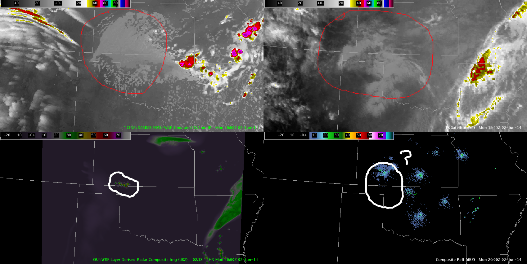 Forecast satellite from the NSSL-WRF and composite reflectivity from the OUN-WRF on the left, actual IR Satellite and composite reflectivity on the right. In the bottom image, the forecast satellite imagery over the area circled in red is actually doing well, however the radar is not. This indicates that these products are probably not the best forecast tools for convection at this time.
-KP
not seeing much with the 500 or 780 mb equiv pot temp, but the difference shows a nice gradient in ne OK. there is a CU field in that area so convection is certainly possible. this does not at all lined up with the ounwrf which shows convection developing at the current time (~20z) further back to the west along the ok/ks border where more persistent cloud cover has been.
jason anderson
Overview:
Today is the first day of operations for the 4th (and final) week of the EWP Big Experiment. Thus, we will begin operations in training / orientation mode.
Forecast:
In the upper troposphere, relatively zonal flow exists across the CONUS. Thus, significant moisture return has commenced, finally solving the moisture problem the Plains has seen this spring season. Vertical wind shear is relatively weak, but the presence of a strong elevated-mixed layer will augment instability and the associated probability of severe weather – especially west.
Two areas of probable severe convection exist: one in the Upper Mississippi / Ohio valley region and the other in the Southern Plains. Given the presence of upper cloudiness to the east, and the lack of a lightning mapping array, we have elected to operate in the Southern Plains today. We have localized the forecasters to two domains: Norman and Wichita.
Gabe Garfield
Week 4 Coordinator