Tracking tool. Just not ready for prime time.

May21st 2234Z

Gave the tracking tool a second chance today.  Bad results. It appears to be a computational issue. I had loaded a 60minute Composite Reflectivity off of MRMS for it to compute. It allowed me set up the circles nicely… however when it started graphing it would only display 2 minutes of difference on the graph initially. About 3 to 5 minutes later It was displaying  4 minutes, 3-5 minutes later it was displaying 6 minutes. So 2 minute increments.

All panes were active while I was grabbing this first screen shot. However, while realizing that both panes were not in the shot; I went back to grab screen shots of the meteogram itself, and discovered that all panes had locked up. A couple minutes later All of CAVE had crashed as if the system had run out of memory.

Grant H.


Tags: None

Anvil Flashes in PGLM

circle_2148UTC2552_fed_anvil_wnldn

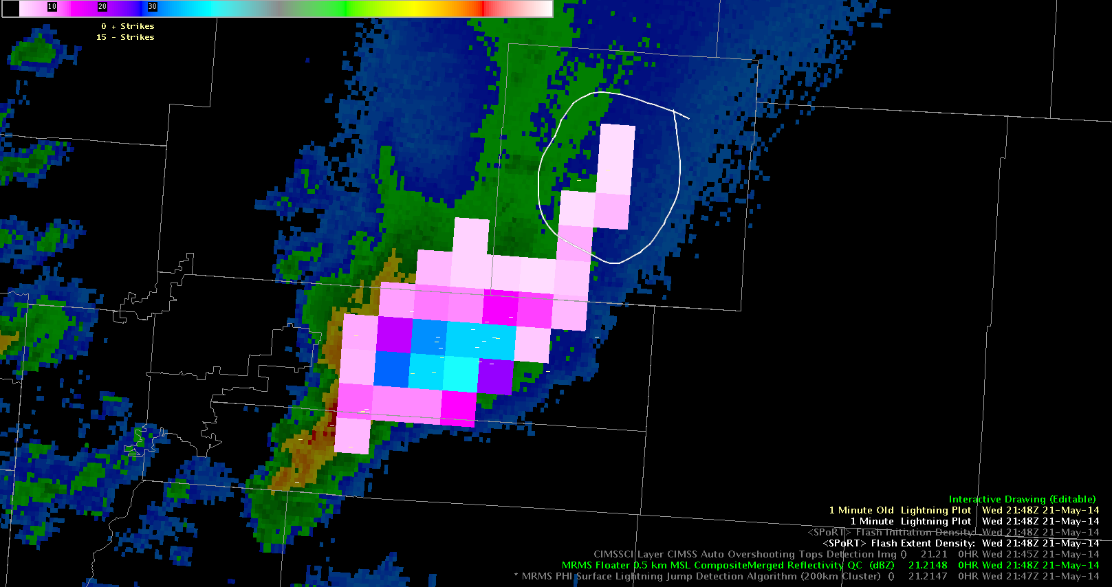
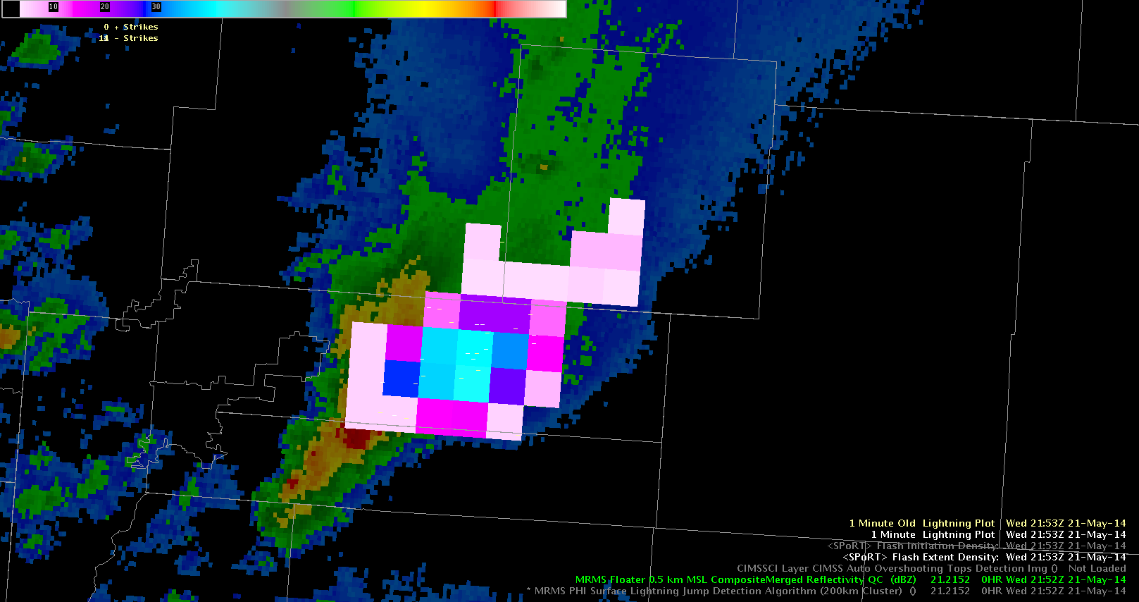
Here are two examples (2148 UTC and 2153 UTC) in northeast CO of how PGLM can be used to detect flashes that propagate long distances into the anvil of storms.  Above is 0.5 km reflectivity, with flash extent density (FED; colored boxes) and NLDN strokes (minus signs).  The highest concentration of flashes is near the updraft core (42 flashes min per pixel), however, note how the flash extent extends well into the anvil region of the storm.  This highlights a region where lightning potential exists.  In the top panel, two NLDN flashes occur in the circled area and in the bottom panel, extensive anvil flashes are noted, but no NLDN information exists in the region where the PGLM shows flash propagation.

Chris S.

Tags: None

Warnings based on Prob Severe

ProbSeverewithRadar


I used the Prob Severe tool today and watched the trends for some of these storms.  It was intensifying the storm each update by 10% and once it got above 60% I warned it.  Sadly the next two updates the storm weakened and so I feel a little let down by Severe Prob.  I may not have needed to issue in the first place.

Tags: None

Missed Hail Event: PROBSVR and MRMS Data

1 inch hail was reported in Union County OH around 2130Z.  The PROB-SVR maxed at 47% a few minutes later and was about 30% at the time of the vent.  MEHS briefly peaked at .7 inches.  However, numerous signatures within both of these products have moved over populated areas without producing severe weather reports.  It seems to be fairly tricky today to get a bead on the severe/non severe thresholds for various experimental products within the ILN CWA.

21May2014-2140Z-PROBSVRBR1

– JRM


Tags: None

ProbSevere vs. LJDA

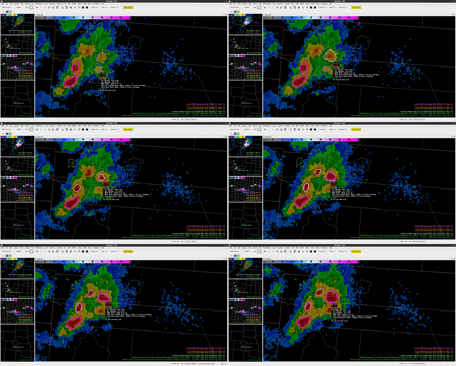
One of our primary goals today was to examine the relationship between the ProbSevere model and the lightning jump detection algorithm. A strong storm fired on the front range of the Rockies, just west of Denver. The ProbSevere model noted strong satellite growth rates in a moderately-sheared environment, with MESH only 0.17″. The probability of severe was 33% at 1920 UTC.  At this time the PGLM indicated a flash rate on the order of 6 flashes per minute.  Two minutes later, at 19:22 UTC, the ProbSevere was 46%, as MESH increased to 0.33″, and the total flash rate at 8 flashes per minute per pixel.   Over the next 4 minutes, two consecutive lightning jumps were indicated in excess of 2 sigma as the total flash rate rose from 8 to 20 flashes/min/pixel (2 sigma jump at 1922 UTC, 4 sigma jump at 1924 UTC).  ProbSevere increased to 66% at 19:24, and 77% at 19:26 (MESH = 0.71″).  This storm intensity information highlighted the rapidly developing updraft within the storm; signalling the potential for severe weather was increasing as the first storm in the area approached the Denver Metro Area.The NWS issued a severe thunderstorm warning at 19:36 UTC. The jump in ProbSevere (46% to 66% from 19:22 to 19:24 UTC) and the 2-sigma and 4-sigma jumps from the LJA (at 19:23 and 19:24 UTC, respectively) may be able to give forecasters enhanced confidence and perhaps more lead time to initial rapid development in the storm, and potential severe hazards. Animated GIFs for Flash Extent Density (top), Lightning Jump Detection Algorithm (middle), and ProbSevere (bottom) from 1920 UTC to 1930 UTC can be seen below.
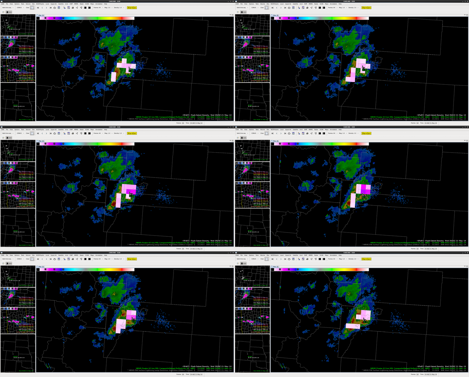
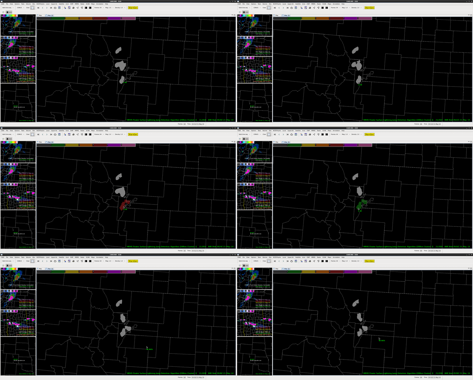
FED_CO LJA_CO CO

Additional lightning jumps were noted at 1943 UTC (3 sigma) followed by multiple 2 sigma jumps at 2000 UTC, 2001 UTC, and 2004 UTC, and another 3 sigma jump at 2005 UTC.  These additional jumps were additional signals that the updraft in the storm was re-intensifying and continued to have the potential to produce severe weather.  Thus any warning that was issued should remain in effect. During this time period, ProbSevere remained at or above 98%. The first tornado report associated with this storm was at 2005 UTC and hail to the size of golf balls were reported in the Denver Metro.  Also hail depth of at least 5 inches was reported at Denver International.

In this case, ProbSevere and LJDA both displayed the rapid intensification of the updraft, and could be especially useful in identifying the first severe storm of the day, and the maintenance of the ProbSevere and additional lightning jumps continued to highlight the threat of severe weather as the storm continued eastward as the storm propagated eastward.  This information is a high temporal resolution (1-2 minutes) and provides additional data points that can fill gaps between radar volume times.

-JC,CS,BW


Overshooting Top batting 1 for 3. 2145Z

May21st 2011Z-1

May 21st 2111Z-2

Here i Just wanted to show that the overshooting top with Cirrus both thick and thin does have some problems. In this case the system appears to be batting 333. Or 1 for 3 attempts.

The 1st attempt was a complete miss for a cluster that had developed in a clearing over southeast Lincoln county. In all fairness this cluster may have not quite been fully developed yet, but did become the dominate cell of the group.

the 2nd Attempt was a hit for a cluster passing through southwest Lincoln county and southeast Elbert County.

The 3rd attempt is a false positive for central Elbert county.

Grant H.

Tags: None

Lightning Jump Picking up on Reorganization

light_jump_21_22

Comparison of the Lightning Jump Detection Algorithm and the radar representation near 22Z is indicating that the once well organized Denver storm may be getting stronger again. Both on the 200 and 600km indicated a 2 sigma increase and the radar presentation now has a well defined BWER associated with the storm indicating better organization.

-JB

Will CI verify?

At 2130Z, the CI product indicated a 90% probability of convective initiation in Lawrence County, IN.

2130Z_Vis_CIBelow is a loop of KIND 0.5Z between 2123Z and 2156Z.

2123Z-2156Z_KIND_refNothing had appeared radar as of this writing but I am waiting with anticipation….

~Linda

Tags: None

Probability of Severe

prob_svr_4_pan

Above you have a 4-panel of MRMS with ProbSvr in the upper level and MRMS rotational shear in the lower level and MESH in the lower right. It is The southwest part of the 99% area is interesting here. Radar presentation would indicate that the area of the storm complex in the southwest is not severe, and MESH only indicates hail up to .3 to .4, but yet the area is still indicated at a 99% of severe. The output indicates that it is a mature storm. I am wondering if it is indicating a larger area than is necessary because it is a mature storm?

-JB

Tags: None

Evolution of the Denver International Airport(DIA) cell. NearCast PW use.

Before: 2028ZMay21st 2028Z

After: 2116Z

May21st 2116Z

So, here I wanted to show that often time the evolution of a storm environment can rely on how much moisture it is ingesting.  The Nearcast PW analysis in the exists in the upper right of both of these images. In the first image it shows a very narrow area of elevated PW to the north feeding into the storm early on with less moisture to the south. All this while the storm was in discrete mode. The second image shows the storm linearising out and spreading south. Along this newly developing line… a wall of higher PW has now appeared in the Nearcast analysis.

Grant H.

Tags: None