
When in doubt…go to areas where there’s an LMA.
…wait…there’s three (maybe four) regions tomorrow? Okay then…
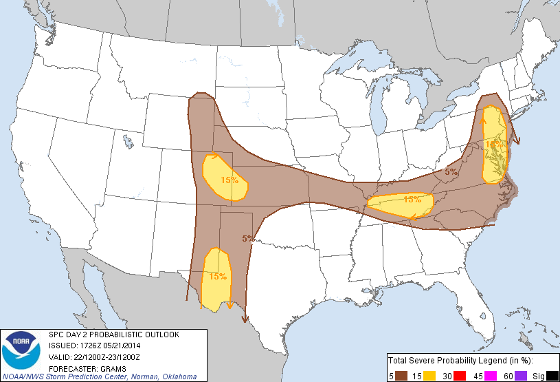
Washington D.C. – Weak cold front will continue to push south, shifting flow out of the northwest by the afternoon. Depending on the amount of surface heating available (if the sun can break through this overcast mess), possibly some convection could fire along the front.
Colorado – Copy…paste from today. But expect weaker southerly flow aloft as the low pressure system very slowly continues to propagate eastward tomorrow. Sufficient lift at the front range and lingering PW values from 0.75-1.00″ could cause more thunderstorms tomorrow afternoon and evening. Don’t expect another ‘Denver Metro Supercell’ though (but maybe I’ll be wrong…I hope I’m not)…
West Texas – Incoming trough + low-level moisture surge overnight with forcast MLCAPE values from 1000-2000 J/kg expected over the region. Early to mid afternoon initiation expected ahead of the dry line.
We have options and hopefully more than 1 will pan out. Most model trends are edging towards a rapid destabilization with earlier initiation around 18z.
We will meet in the Dev Lab tomorrow at noon for a debrief before meeting in the HWT by 12:30pm.
-Darrel Kingfield
EWP Week 3 Coordinator