Starting This Monday – The PHI and Big Spring Experiments (Week 4)

Monday 2 June 2014 begins the fourth and final week of our spring experiment of the 2014 NSSL-NWS Experimental Warning Program (EWP2014) in the NOAA Hazardous Weather Testbed at the National Weather Center in Norman, OK.  There will be two primary projects geared toward WFO applications, 1) a test of a Probabilistic Hazards Information (PHI) prototype, as part of the FACETS program and 2) an evaluation of multiple experimental products (formerly referred to as “The Spring Experiment”).   The latter project – known as “The Big Experiment” – will have three components including a) an evaluation of multiple CONUS GOES-R convective applications, including satellite and lightning;  b) an evaluation of the model performance and forecast utility of two convection-allowing models (the variational Local Analysis Prediction System and the Norman WRF); c) and an evaluation of a new feature tracking tool.  We will also be coordinating with and evaluating the Experimental Forecast Program’s probabilistic severe weather outlooks as guidance for our warning operations.  Operational activities will take place during the week Monday through Friday.

For the week of 2-6 June, our distinguished NWS guests will be Jason Anderson (CWSU Minneapolis, MN), Michael Fowle (WFO Aberdeen, SD), Kathleen Pelczynski (WFO Raleigh, NC), John Stoppkotte (WFO North Platte, NE), and Peter Wolf (WFO Jacksonville, FL).  Additionally, we will be hosting a weather broadcaster to work with the NWS forecasters at the forecast desk.  This week, our distinguished guest will be Dan Satterfield of WBOC-TV (Salisbury, DE).  If you see any of these folks walking around the building with a “NOAA Spring Experiment” visitor tag, please welcome them!   The GOES-R program office, the NOAA Global Systems Divisions (GSD), and the National Severe Storms Laboratory have generously provided travel stipends for our participants from NWS forecast offices and television stations nationwide.

Visiting scientists this week will include Alex Anderson-Frey (Penn. St.), Vesa Nietsosvaara (EUMETSAT), and Yuanfu Xie (GSD).

Gabe Garfield 
will be the weekly coordinator.  Matt Elliott (WDTB) will be our “Tales from the Testbed” Webinar facilitator. Our support team also includes Kristin Calhoun, Darrel Kingfield, Bill Line, Chris Karstens, Greg Stumpf,  Karen Cooper, Vicki Farmer, Lans Rothfusz, Travis Smith, Aaron Anderson, and David Andra.

Here are several links of interest:

You can learn more about the EWP here:

https://hwt.nssl.noaa.gov/

NOAA employees can access the internal EWP2014 page with their LDAP credentials:

https://hwt.nssl.noaa.gov/ewp/internal/2014/
Gabe Garfield
CIMMS/NWS OUN
2014 EWP Operations Coordinator

Tags: None

EWP2014 Week 3: Weekly Summary 19 May – 23 May 2014

Project Overview:

This was first week of our four-week spring experiment of the 2014 NSSL-NWS Experimental Warning Program (EWP2014) in the NOAA Hazardous Weather Testbed at the National Weather Center in Norman, OK.  “The Big Experiment” or “Spring Experiment” had three components:  (1) an evaluation of multiple CONUS GOES-R convective applications, including satellite and lightning;  (2) an evaluation of the model performance and forecast utility of two convection-allowing models (the variational Local Analysis Prediction System and the Norman WRF);  (3) and an evaluation of a new feature tracking tool from NASA SPORT.  Additionally we coordinated daily with Experimental Forecast Program, participating in briefings and evaluating the probabilistic severe weather outlooks produced by their forecasters as guidance for our warning operations.

Participants:

Our NWS participants were Joshua Boustead (WFO Omaha, NE), Linda Gilbert (WFO Louisville, KY), Grant Hicks (WFO Glasgow, MT). Our visiting broadcast meteorologist for the week was Danielle Vollmar of WCVB-TV (Boston, MA). The GOES-R program office, the NOAA Global Systems Divisions (GSD), and the National Severe Storms Laboratory provided travel stipends for our participants from NWS forecast offices and television stations nationwide.

Visiting scientists this week included Steve Albers (GSD), John Cintineo (Univ. of Wisconsin/CIMSS), Ashley Griffin (Univ. of Maryland), Chris Jewett (Univ. of Alabama – Huntsville), James McCormick (Air Force Weather Agency), Chris Schultz (Univ. of Alabama – Huntsville), and Bret Williams (Univ. of Alabama – Huntsville).

Darrel Kingfield 
was the weekly coordinator.  Lance VandenBoogart (WDTB) was our “Tales from the Testbed” Webinar facilitator for his last week (we’ll miss you!). Our support team included Kristin Calhoun, Gabe Garfield, Bill Line, Chris Karstens, Greg Stumpf,  Karen Cooper, Vicki Farmer, Lans Rothfusz, Travis Smith, Aaron Anderson, and David Andra.

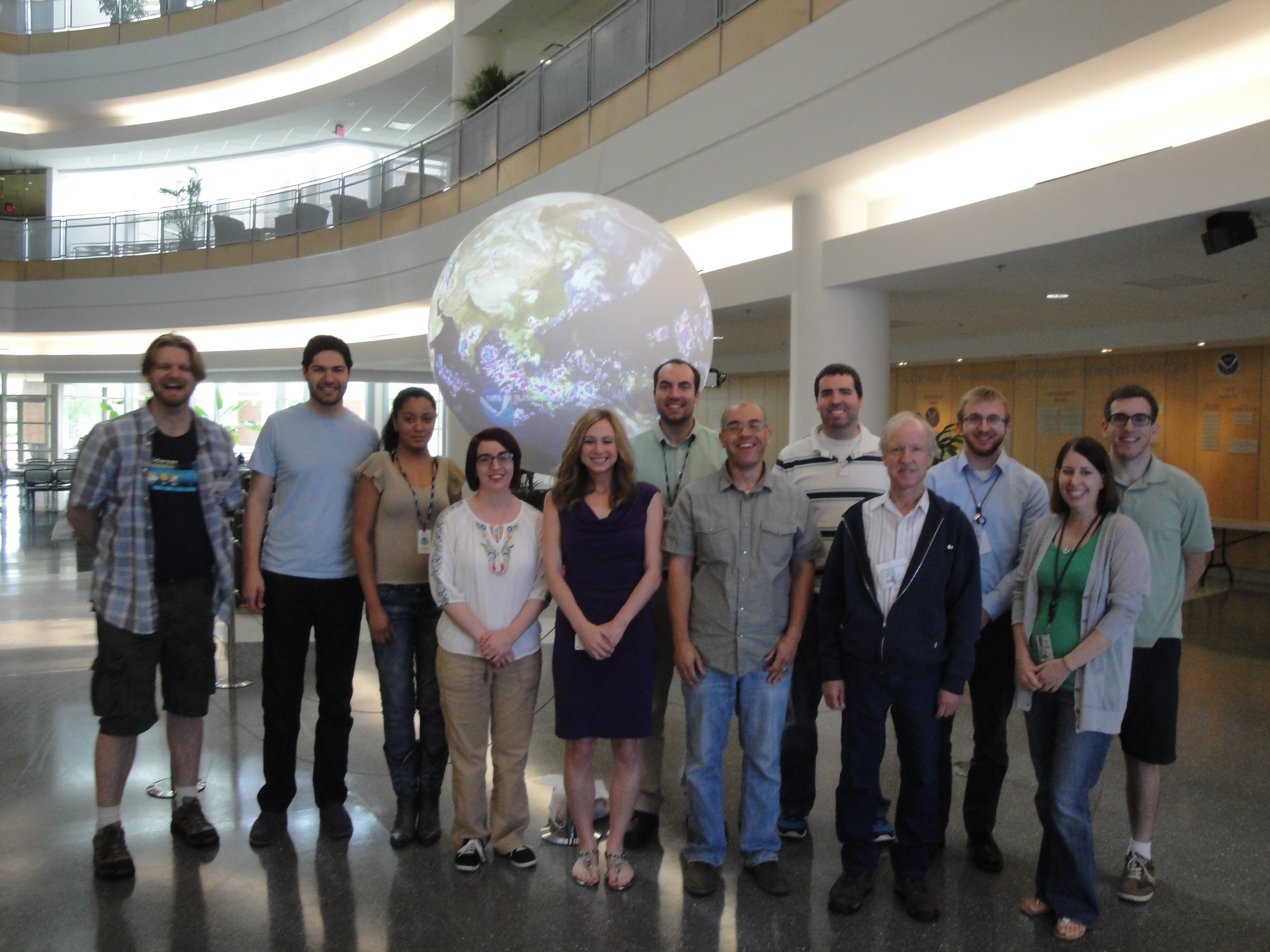
Some of our EWP Week 3 participants. Many others had to catch their flights early :(
Some of our EWP Week 3 participants. Many others had to catch their flights early 🙁

Feedback on Experimental Products:

Synthetic Imagery (simulated satellite via NSSL WRF):
  • The technique is great, to be able to visualize what the satellite would look like if this model were to pan out.

  • Sometimes it got the correct position and missed the timing, sometimes it got the timing and missed the position.
  • Would be great to integrate with other model solutions.
Nearcast:
  • I liked that you could see the areas of higher instability. When I used it in conjunction with the ProbSevere or CI products, I found it helpful to see if cumulus field is developing in a region of higher instability.

  • The wide spectrum of colors allowed for the analysis/tracking of instability gradients
  • Lots of blank spots due to cloud cover, becomes hard to use in heavily overcast conditions. Would be great to blend with other NWP solutions.
  • I could see myself going to this product between warnings see where the Theta-E gradient is located.
  • Could be used to fill the spatial gap between sounding data sites.
 GOESR Convection Initiation – probabilities:
  • Really helped focus my attention to specific regions of favorable convection and block out other regions for now.
  • Could catch a forecast off guard if he/she is unaware of the deficiencies (e.g. poor detection capability under cirrus).
  • Mixed results depending on isolated initiation versus new initiation in a complex convective setup.
  • I’m unsure how well GOES West is performing compared to GOES East.
ProbSevere –
  • I liked the verbal annotations next to the metadata (e.g. Moderate, Strong)
  • After initial hesitation, the algorithm performed really well today (5/20) and I was confident in using it as guidance.
  • Highlighted storm collapse, helping me not issue warnings on storms that were weakening.
  • I could see this catching things a human would miss but we should still use it in conjunction with base data.
Overshooting Tops:
  • The 15-30 minute updates made it difficult to use, I’d be more receptive to 1 minute updates.
  • I see more overshooting tops than what the algorithm is detecting but see its potential when there is no visible imagery (i.e. nighttime).
  • I could see this filling the gap in a data void region without radar.
Super-Rapid Scan (SRSOR), 1-min imagery:
  • 1 minute data allowed me to gain more confidence in what I was seeing. I saw convective attempts, failures, and dead anvils…something I could not see as clear without SRSOR imagery.
  • The detail seen in convective development was phenomenal, I could stare at this all day.
  • I was able to visually identify boundaries feeding into the storm faster than what radar could provide to me.
pGLM –
  • CG information did not tell the whole picture, it was great to see the ups and downs in electrification.
  • I could definitely integrate this into warning operations.
  • Definitely helps in monitoring the health of the updraft pulse.
  • I factored the sigma jumps into my decision making process and overall it performed well.
SPORT tracking tool:
  • I think it has potential but the bugs/freezing when loading a lot of data made it difficult to use.
  • I tracked base velocity with this tool and when multiple meteograms started popping up, I just closed it out.
  • I liked how the path prior trajectory changed by moving a single circle but it will take some time for me to do this faster. Unsure how to integrate this into fast-paced convective modes.
vLAPS :
  • Seemed to overproduce convection consistently but I found the instability parameters useful.
  • Wind and Theta-E fields would be an added benefit.
  • Odd features seemed to propagate near the edges of the domain, which sometimes made the small domain products difficult to use.
  • Composite reflectivity seemed way to hot to use this week.

-Darrel Kingfield, EWP Week 3 Coordinator

Tags: None

Daily Summary: Week 3, Day 4 (May 22nd, 2014)

Another solid day in the HWT as our forecasters remained in LWX and OHX for the duration of their shift. All experimental products (yes! even OUNWRF) were evaluated today.

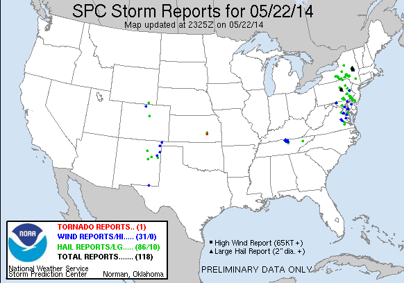
SPC Preliminary Storm Reports from May 22, 2014.

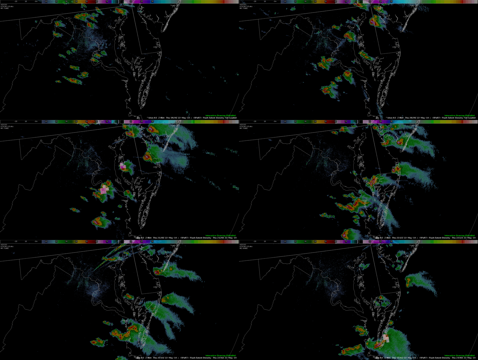
Our LWX team was able to evaluate pre-CI potential using GOES-R CI, LAPS, NearCast, and ProbSevere. When storms got close to LWX our team (Grant and Danielle) were able to use DCLMA network to evaluate total lightning and lightning jumps. The were several preliminary reports of hail and wind damage in the region passed along by our volunteers which helped forecasters validate what they were seeing in the experimental datasets.

KLWX 0.5 deg reflectivity with Flash Extent Density from DCLMA from 1924z-2341z. Due to time matching contraints with radar, some DCLMA products did not show up.
0.5 deg reflectivity from KOHX with visible imagery from GOES-13 from 1915z - 2349z.
0.5 deg reflectivity from KOHX with visible imagery from GOES-13 from 1915z – 2349z.

Our OHX team waited anxiously as slow moving storms fired in the LMK and PAH CWAs with NW flow pushing slowly into the CWA. Once again, forecasters had some time pre-CI to get a feel for how the GOES-R and LAPS products were able to diagnose areas of instability and identify storm growth and intensity. The Overshooting Top Detection product was evaluated frequently in conjunction with the Super-Rapid Scan imagery in this domain with a fair amount of detections occurring today.

Furthermore, our visiting forecaster from the Air Force Weather Agency, James McCormick, worked with Gabe to thoroughly evaluate OUNWRF across the entire domain. Many thanks to him for giving us a focused set of eyes on this!

-Darrel Kingfield
EWP Week 3 Coordinator

Tags: None

I checked out the OUN WRF

oun wrf

I decided to check out the OUN WRF and I was impressed it picked up the line of convection in Oklahoma very well. It was still a little overdone in the Panhandle but other than that good first impression. ~ Vollmar

Tags: None

Verified CI

While not necessarily in my area of interest today, my attention was drawn to PAH’s CWA at around 22Z when the CI product indicated a 70% probability of convection initiating. Admittedly, I didn’t place too much stock in it as there have been false probabilities showing up this afternoon (plus it is outside of my area of focus). However, within the next half hour, convection developed in the same area.

2136-2250Z_SRSOR&CI

~Linda

Tags: None

ProbSVR Showed Downward Trend

prob_svr_initial

With a significant increase in ProbSvr and good environmental conditions Linda issued a severe thunderstorm warning for a storm in northern TN. ProbSvr at this time was near 90% at this time.

prob_svr_down

Two volume scans later, while the reflectivity was still fairly significant the ProbSvr dropped to 48 percent. Two more volume scans later the reflectivity looked like the above image where the storm was obviously weak. This downward trend in ProbSvr was great since it was near the southern end of the severe thunderstorm warning and another warning decision was near.

-JB

Tags: None

Simulated Satellite this afternoon

Simulated Satellite V. Infared with Convection

When looking back at Simulated Satellite today and seeing how it performed, it actually did very well.  It was on point with the timing of initiation of convection and the location of the start of the storm as well as how they moved.  The only thing it really lacked was the strength of the storm.  I would use this product for forecasting purposes! ~Vollmar

Tags: None

Experimental warning issued based on…

…the prob. severe model and SRSOR as well as radar interrogation. The prob. severe model latched on to a storm near the intersection of Sumner, Trousdale, and Macon counties at 2212Z but I wasn’t able to view the actual prob. severe model product until after 2217Z, leading to the warning not being issued with even greater lead time, as I had hoped to be able to do. While waiting for the updated prob. severe model product to come in, I analyzed the super rapid scan imagery and noticed the growing cloud tops between approximately 2207Z through ~2223Z. After the warning was issued, I re-analyzed SRSOR and an OT was detected in the vicinity of the cluster of storms.

21Z-2231Z_ref_probsvr

2120-2232Z_SRSOR&OTD

~Linda

Tags: None

OT Detection

May22nd 2240Z

Another shot at the OT algorithm.  The OTs are placed over the IR satellite in the upper left and are very much bias towards this imagery.

Looking to the right at visible satellite imagery, clearly only one OT is evident in Gloucester and Atlantic County where 4 are showing.

Thinking about how the forecaster IDs OTs on visibility, it appears to be a sharp/rough contrast of colors that draw the eye in… versus a smoothness of color downstream.

If there was a way to add this to the weighting of the algorithm it may help to discourage False Alarms.    On the other hand that could force it to be a daytime only product…. Unless you set in a series of changing variables based on time and angle of the sun.

May22nd 2251Z

Here we have a second OT Detect out over the Atlantic at the edge of the domain . This one does pretty good.  This got me thinking… This Algorithm may be best used for someone like the AWC which needs as much data as possible in a data sparce area such as the oceans.

If a greater than 50% chance of severe damage could be directly coorelated to OTs on land…. then they probably would be helpful in identifying Convective SIGMETs areas in a data sparse region over the ocean.

Just Ideas…

Grant H.

Tags: None

Laps Today

LAPS 18Z

I know I wasn’t in this area forecasting today, but I wanted to see how the LAPS Reflectivity did today since I wasn’t as inclined to use it yesterday.  I initially tried to use it 2 hours ago, but it was not working.  However, I was told that it had moved areas so it needed time to play catch up and ingest the new data.  However, when I loaded it now at 22Z the model run that loaded was the 18Z with a snapshot even from 17Z.  Not sure what is going on there, but now it would not be a tool for forecasting but just for verifying because it has loaded up all the way.  As you look it does pick up on the cu-field, but missed the larger storms up in the N&W.  I am not sure what is going on with it unless since I am in DC I can’t use it?  ~Vollmar

Tags: None