Live Blog – 20 May 2010 (4:15pm)

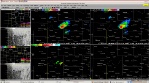
Dave has set up an 8-panel set-up that he likes:

  • RotationTrackML30min
  • RotationTrack30min
  • AzShear0-2
  • AzShear3-6
  • MESH
  • EchoTops50
  • Reflectivity_-20C
  • Base-tilt of reflectivity from nearest radar

Gives a nice overview of all the main parameters that he is interested in monitoring, and makes for fast toggling.

Volume browser loading was slow in HWT — may be faster in real AWIPS.

Travis Smith (EWP Weekly Coordinator, 17-21 May 2010)

Tags: None

Outlook – 20 May 2010

We will focus on the ongoing area of convection (tornado watch) in the FWD CWA for the afternoon.  Later in the day, convection is expected to move into the Huntsville LMA domain.  The current plan is to concentrate on the FWD area until around 5 or 5:30pm, take a dinner break, and then switch to the N. Alabama domain for evening operations.

There are two tornado-warned storms along an east-west boundary in the CWA at the start of operations (3pm).

Travis Smith (EWP Weekly Coordinator, 17-21 May 2010)

Tags: None

Daily Summary – 19 May 2010

Activities cenetered on the central Oklahoma High Risk area today, with both teams using a Norman (OUN) localization.  Unfortunately, the OK-LMA network was down, and we were unable to do an analysis of the pseudo-LMA product.   The two teams first sectorized between two supercells north of I-40 ( the westernmost storm being the V2 storm).  Later, as convection developed south of I-40, the sectors were repositioned to be one for the north of I-40 storms, and one for the south of I-40 storms.  All told, our teams issued 71 experimental warnings or severe weather statements today.

For the GOES-R products, one of the main comments from this event is that they all felt the proxy products from the current GOES satellites isn’t doing justice to the expected capabilities of GOES-R with increase temporal and spatial resolution.  For example, there were fewer overshooting top detections that one forecaster would have expected.  The CI products worked a little better today owing to less cirrus obscuration.  There is a lot more information about this in the GOES-R HWT Blog daily summary.

The forecasters are gaining even more familiarity with the MRMS products.  One comments noted that it is nice to be able to look at just one multi-radar product (e.g., 50 dBZ Echo Top) rather than having to figure it out from the many single radars and all-tilts sampling.  Once again, they are discovering that the tracks products (hail and rotation) add a lot of value in determining at a glance both the storm motion (and very stable) and the storm intensity trends.   They also found that the MESH was doing a good job at matching the actual reports, but that the bias-corrected MESH as under-doing the estimates by 1/4-1/2″.

Greg Stumpf (EWP2010 Operations Coordinator)

Tags: None

Wed 19 May 2010: Operations Update 7:40 pm CDT

Team 1:  Storms moving out of OUN localization and into Tulsa. TOR warning continues for storm near Guthrie, OK, velocity signature noted from KVNX radar. Storm has slowed movement towards the east.  Also watching storms in NW OK in Woodward County.  SVR warnings for probable 1 in and larger hail.  Reflectivity at -20 C nearing 60 dBZ.  (Overshoot product is having problems connecting with AWIPS; possible that GRIB2 products are not being created at the current time)

Team 2:  TOR and SVR warnings for McClain and Cleveland counties for storm moving through Noble, OK.    Also maintaining TOR and SVR warnings for storm that moved through Duncan, OK in Stephens County.  May let the tornado warning expire for Cleveland County storm as rotation track products appears weak and velocity signature doesn’t appear as significant.  Perhaps has become outflow dominant.

Kristin Kuhlman (GOES-R/PGLM Principle Scientist)

Tags: None

Live Blog – 19 May 2010 (6:45pm)

Team 1:  Continuing Operations with northern two tornadic storms.  Stillwater storm appears to be cycling with new circulation forming further south as old one occludes.  Baseball size hail still expected in western storm with 60 dBZ noted at -20 C in Kingfisher/Logan Counties.

Team 2: Focus on storms from Grady to Cleveland counties. One SVR warning for storm in Lincoln County entering the Tulsa CWA.  CASA and OU prime radars are being used to examine features not seen by the 88D radars: depicting organizational features quicker particularly with cluster of cells merging in Grady County.  Storm north of Norman (in KTLX cone of silence) appears to be picking up in intensity though rotation product appears to be some what corrupted in the location.  Also examining new storm increasing in intensity near Lawton in Comanche County.

Kristin Kuhlman (GOES-R/PGLM Principle Scientist)

Tags: None

Live Blog – 19 May 2010 (5:40pm)

Team 1:  Taking all 3 northern storms (2 eastern with current TOR warnings, western storm had earlier tornado report, but appears to be dissipating at the current time).   Rotation track shows significant values with eastern storm — Tornado currently on ground SW of Marshall, OK.  Overshooting top algorithm shows detection on in Garfield County at 2210 UTC.  Bias-corrected MESH contains values much too low: 3.25 in hail reported, bias-corrected MESH reading only 1.5 in.  Normal MESH values around 2.75-3.00 in.

Team 2:  Focusing on development in SW Oklahoma.   Storms appear to be struggling, unable to reach warning criteria.  Watching -20 C reflectivity and CASA radar data on storm north of Lawton in Caddo County.

Kristin Kuhlman (GOES-R/PGLM Principle Scientist)

Tags: None

Live Blog – 19 May 2010 (4:35pm)

Team 2:  Issued a 45 min TOR warning for storm in Kingfisher County until 5:15 CDT.  Held off issuing until rotation signature picked up in strength and reflectivity notch appeared in KVNX as well.  Also, coherent signal in AzShear and MESH were noted at the time of warning.  Reflectivity @ -20 C also picked up post warning.

**Dewey county storm showed some 13 min lead time from CI product before 35 dBZ reflectivity from KTLX.    CI product showed concurrent appearance with 35 dBZ echo for storms in Ellis Co. and Kingfisher Counties.

Cu line forming along the dryline and secondary boundary (HCR?) noted from GOES satellite NW of Lawton in Comanche and Kiowa Counties.  CI product flagged area at 2125 UTC; 35 dBZ reflectivity noted at 2130 UTC from KFDR. Team 2 monitoring this region.

Kristin Kuhlman (GOES-R/PGLM Principle Scientist)

Tags: None

Live Blog – 19 May 2010 (4:10pm)

Team 1:  Continues focus on NW OK storms.   The Ellis/Woodward county storm  and the Dewey Co. V2 supercell.  They have reissued a TOR for the Dewey county storm (velocity, TVS) and maintain a SVR on the Ellis Co.   Have been using the cloud top cooling product as well as AzShear and MESH products.

Team 2:  Watching storm near Lacey, OK in Kingfisher Co.  Have decided not to issue a TOR or SVR warning as couplet is displaced from reflectivity core and see low values form AzShear products; low reflectivity at -20 C doesn’t seem to warrant a SVR for hail at the moment.

Kristin Kuhlman (GOES-R/PGLM Principle Scientist)

Tags: None

Live Blog – 19 May 2010 (3:40pm)

Both teams are working with Norman localization.

Team 1 is focusing on the Vortex 2 storm in NW Dewey County.  First issued a severe based on core values (held off longer than local WFO due to low MESH values and core reflectivity aloft) , but quickly followed with a tornado warning as the vortex2 crew and local television reported a funnel cloud.   MESH and Rotation tracks (AzShear) products are being monitored with the storm.

Team 1 will continue to focus on the Dewey County storm and storms NW of the region.  Team 2 is examining the storm in Blaine County and the area along I-40 towards the metro region for other storm initiations.

Note:  GLM Lightning data products are currently unavailable due to maintenance on the local OK Lightning Mapping Array network.

Kristin Kuhlman (GOES-R/PGLM Principle Scientist)

Tags: None

Outlook – 19 May 2010

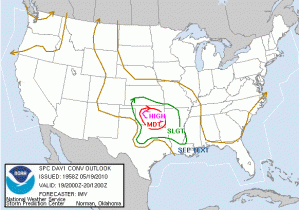
A significant severe weather day is underway for central Oklahoma (SPC high risk [see image] and PDS tornado watch valid from 2pm -10pm CDT).  After a post-event wrap of yesterday’s operations, forecasters quickly reviewed current conditions and model forecasts from the HRRR, NSSL-WRF and OUN-WRF.  By 2pm CDT activities had begun in the HWT with two teams examining the GOES-R convection initiation products for storms along the dryline in western OK.

Travis Smith (EWP Weekly Coordinator, 17-21 May 2010)

Tags: None