Live Blog – 3 June 2009 (3:00 pm)

Pete noticed that at ~1950 UTC SW of KLWX, three storms had different lightning characteristics. The furthest SW had CGs before LMA showed anything, the in the middle had LMA and CGs at the same time, and the furthest north had LMA first prior to any CGs.  The furthest SW storm was the most severe on radar and highest lightning concentration on LMA, thus Pete quickly issued an SVR.

Liz Quoetone and Paul Schlatter (EWP Weekly Coordinators, 1-5 June 2009)

Tags: None

Outlook – 3 June 2009

June 3 Day 1 Outlook

Once again, the LWX CWA and the LMA domain is active with a SVR watch already out.  SBCAPE is around 2000 across VA, particularly well south of the quasi stationary frontal boundary that has been around for several days.  This will primarily be a wind threat with a marginal hail threat.  With very high CAPE possible across E. VA, SPC issued a 2% tornado threat.  Deep layer shear is once again paltry, with around 30 kts.  Areas with weak easterly winds, near the frontal boundary, will see the greatest deep layer shear.  The group will work an LMA IOP for the Sterling CWA until dinner time (5 or 530ish), then work a PAR/CASA tag team archived event.

1900 UTC Surface Map

Medford will again see severe storms this evening, but it was decided to focus on the LMA network and PAR/CASA archived events.  Tomorrow Medford is once again in a slight risk, so that could be an alternate IOP to the very weak CAPE/Shear expected in eastern Colorado (see graphic below).

June 3 Day 2 Outlook

Schedule:

230-500 PM: LMA IOP for the LWX Domain
500-530 PM: Dinner
530-700 PM: PAR/CASA Archived event tag team (one group on PAR, other on CASA, then switch at 700)
700-830 PM: PAR/CASA Archived event tag team

Liz Quoetone and Paul Schlatter (EWP Weekly Coordinators, 1-5 June 2009)

Tags: None

Summary – 2 June 2009

At the 1 PM briefing on June 3, group got together to discuss yesterdays activities.

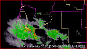
MFR IOP: MESH was useful and seemed to be accurate in size relative to the reports given. -20C Z was helpful because many storms across the domain had high reflectivities but not much into the hail growth zone, but the deepest storms that led to the warnings showed up nicely on the -20C Z products.  MESH showed 1 inch at one point, leading to the issuance of the warning, which verified. Enough shear present for MESH to do a good job at size estimation….where normally weak sheared environments MESH used to overforecast (when it was cell based).  Would be interesting to find out if gridded MESH continues to overestimate hail size.  All tilts reflectivity was used to draw the warning polygon, MESH used to zero in on threat area.  One team also used VIL to find the deepest/most threatening storms, and for this event they found 35 VIL sufficient for 0.50 inch hail, greater values for potentially severe hail.

Interesting rotational signature with greater than 50 kts velocity difference at 12 kft MSL on the western end of the storm complex.  Signature was nearly stationary for 25 minutes, and corresponded to a peak in the MESH of just over an inch before dissipating.  Reflectivity deformed with the circulation as well.

LMA Thoughts from the IOP:

  • Good event for training…to show what LMA can and can’t do given isolated, not widespread coverage of storms.
  • Was able to track updraft cores in the LMA data.
  • DC network had some problems yesterday, missing some storms.
  • Impressed with how the LMA cores followed the reflectivity cores.
  • Next step for LMA data is to get trends into SCAN
  • LMA would be very valuable in radar-sparse areas or in blockage areas
  • GLM for warning input was sufficient to find the significant storms. Also agreed that the most benefits would likely be in the WR
  • ICahead of CC, CC before IC, or same time in growing storms: Good research topic to see which occurrence might lead to useful intensification information.
  • Algorithms based on LMA data could be useful, like a TVS type thing, but big questions about how this might differ from SCAN type alerts and the algorithms it uses

Discussion moved towards data overload if/when 1 min volume scans become operational, in addition to new radar products and algorithms and other sources of data.  Will be a VERY big challenge trying to figure out which data are most important and how to effectively manage all the data.  We don’t really know what the impact of all that data will have on operations.

Liz Quoetone and Paul Schlatter (EWP Weekly Coordinators, 1-5 June 2009)

Tags: None

Live Blog – 2 June 2009 (8:44pm) – End of IOP Summary

LMA (Sterling/Mt. Holly CWAs):

All 4 folks viewed event over Eastern US in Sterling’s LMA area. This was a good first case to illustrate some of the characteristics of the data sets. Some in the group were surprised at the value of the data set, thought to be especially beneficial for areas with no radar coverage. Vilma was especially useful, Some questions that came up were in regard to the meaning of LTGiC  vs LTGCG which initiate at the same or different times in the storms life.  Looking forward to getting more exposure to data sets.

MR/MS IOP over N. CA and S. OR (MFR CWA):

No areas of rotation so rotation tracks not very useful in this event.  However, MESH was very useful, especially since it appeared to be accurate.  They paid attention to trends in MESH and how they correlated to the reports they received.  Reflectivity at the -20 level and the height of the 50 dBZ was not impressive, nor was VIL, and these agreed with MESH but it was useful that MESH actually provided an accurate hail size.  VIL 45 was roughtly their warning threshold.

Pete mentioned that -20 C was useful to identify where the most likely location of the hail cores were located.  He wished there was more information provided by gridded products for the theat of winds.  He noticed a weak, though well defined MARC signature in the SRM data via All Tilts from KMAX shortly after issuing the first SVR.  He tries to really examine the NSE (near storm environment) closely to aid in the warning decision process for severe straight line winds.

Veronica:  Echoed statements from others and added that 50 dBZ and 30 dBZ contours and the reflectivity at -20 C were useful in the evaluation of hail threat for this marginal event.

Liz Quoetone and Paul Schlatter (EWP Weekly Coordinators, 1-5 June 2009)

Tags: None

Live Blog – 2 June 2009 (6:45 pm)

Storms in the MRF CWA show decent cores around the freezing level but struggled to get anything into the hail growth zone.  MESH was monitored to any intensification.  Interesting report came in from EKA office, maybe 50-75 miles south of the MFR CWA of penny hail, shown below.

Penny Hail Report Peanut, CA

An attempt was made using MESH and All Tilts to figure out what led to this report.  MESH didn’t show much, neither did All Tilts.  Both teams were unable to discern for sure if beam blockage played a large role in how paltry the storm in the area of the report looked.

Liz Quoetone and Paul Schlatter (EWP Weekly Coordinators, 1-5 June 2009)

Tags: None