Week 5 Summary: 1 – 5 June 2009

On Friday morning, the group got together to discuss June 4 activities and overall thoughts from their week in the HWT.

  • want to transition from RPG-only algorithms to including NSE data into any radar algorithms
  • If looking at 1 min radar scans…hard to keep tabs on changes in 0-1 km wind shear for example, or any other NSE parameter for that matter.  Would like to see an envionmental algorithm paired or integrated into radar algorithms
  • The NSE data needs to be reliable and accurate, otherwise it would be detrimental

PUB/BOU/CYS IOP:

  • Near end of IOP a storm moved right over the KCYS radar, MESH did it’s job using multiple radars to fill in the cone of silence.  However, MESH seemed to be overestimating compared to the reports that SHAVE were getting (1.00 inch vs. 1.7-1.9 inches)
  • MESH tracks showed where storm had been going and was consistent, allowing the warning polygon to be oriented the right way

MR/MS Discussion

  • MR/MS doesn’t account for refraction properties yet, though a QC check does eliminate much of the AP
  • Mid-level rotation tracks were useful to help find a consistent track of the rotational signatures.  They also help confirm you have a supercell when the tracks are consistent
  • Like examining the trends in -20C reflectivity
  • Lots of the gridded products are redundant, containing the same type of information.  Have to be careful not to get tunnel vision when using all these gridded products. Redundancy also helps you transistion from products you are use to using to the new products and grow expertise and confidence.
  • Be comfortable with the gridded products in order to properly integrate them into the warning decision process
  • Plan view plot of scan-to-scan change would be useful…like change in MESH from scan-to-scan.  They all thought that trends were every bit as important as the max values reported.
  • Google map displays:  really want those in their local offices

LMA

  • impressive, never used the data before but very useful in areas were radar data may be lacking
  • need research to see if LMA data vs. cloud to ground data in the early stages of storm formation means anything
  • LMA is an average, then AWIPS smooths it further, thus losing information
  • They like the high res appearence, how it is similar to radar reflectivity.
  • Using it to help forecast when a storm first becomes severe, at the very least use it to get some led time on rapid intensification
  • #1 killer in FL is lightning…Pete hopes that there is a focus on provided an improvment on service for lightning threat

CASA

  • Need low-level altitude resolution that CASA provides.  This is crucial information the 88D can’t always provide.  This is a “big positive”
  • A consideration with CASA is that it provides rapid scan updates that could give a few extra minutes of lead time, but won’t be more than a few minutes.  Selling point will not be verification scores but the one devastating tornado you catch that formed well below the 88D’s lowest scan
  • Will see lots of signatures on CASA that haven’t been seen before and don’t currently know how to interpret.  Will be steep learning curve for these new/different signatures
  • Used reflectivity quite a bit to infer presence of a tornado becuase with the high resolution in time and space they were able to see the “do-nut” signature common with tornadoes
  • Will see a lot more low-level rotational signatures, do you warn on every little 30 sec dust whirl that shows up on CASA that you would never see with the 88D?  Obviously if each one is an actual tornado then yes, but gray area if they are very short lived and weak.  Could see a lot more warnings come out.
  • 1 min data might be more tempting to hold off on a warning, waiting one more scan, then waiting one more scan.  Can ride the fence on warn/don’t warn a little longer.  Not sure if this might be a real impact, will need to do some research on this, maybe on the WES.
  • Big learning curve and training will be needed to grow accustomed to 1 min updates

PAR

  • Provided more rapid updates but didn’t have any other advantages, since resolution is about the same if not worse at the edges of the scan sector, and also the same elevation angles.
  • Pete will take PAR data capabilities back to JAX with lots of excitement because it helps with the low-topped, weak signature supercells in tropical environments.  PAR allows for detection and tracking of rapidly evolving weakconvergent and rotational signatures.  PAR should also help with pulse-type storms because of rapid evolution, getting early detection of cores aloft that the 88D might miss.

Liz Quoetone and Paul Schlatter (EWP Weekly Coordinators, 1-5 June 2009)

Tags: None

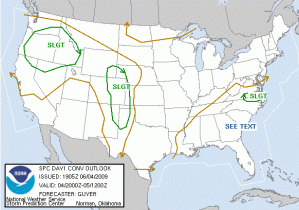
Outlook – 4 June 2009

Running PAR/CASA archive cases for the next 1-2 hours. Will attempt to run IOP at 4 PM for the BOU CWA.  Good hodographs (very straight lines) could mean splitting storms with 40 kts 0-6 km shear and 1000-1500 J/kg CAPE.  No CIN to speak of.  Need to get further heating N of the Palmer Divide and with the low clouds burning off this should happen by 4 PM.  Radars running at KFTG, KPUX, KGLD, and KCYS.  VORTEX 2 is also in the area east of Denver.

June 4 Day 1 Outlook

Liz Quoetone and Paul Schlatter (EWP Weekly Coordinators, 1-5 June 2009)

Tags: None

Summary – 3 June 2009

At the start of the 1 PM meeting on 6/4/2009, the group summarized yesterdays activities.  We did an LMA IOP for LWX/AKQ, then PAR and CASA archived events.

LMA IOP

  • We re-examined the 3 storms around 1950 that had varying LMA attributes vs. CG attributes.  In particular one storm that looked impressive on radar had very high amounts of CGs, but LMA didn’t show much.
  • Need to be able to explain why the storm didn’t show up in LMA yet had high CG rates and good reflectivity characteristics aloft, because this particular storm would be an example of when the LMA doesn’t not perform as expected, and in a way detrimental to storm interrogation.
  • MESH didn’t agree with the VIL, LSRs, Z at -20C…seemed to overestimate the hail in the LWX CWA
  • LMA helped get a warning out quicker than normally would b/c they were able to monitor trends in the LMA, looking for a rapid increase in flash rates
  • For warning decisions, Bill/Veronica used VIL, Z at -20 C, MESH, and was looking for things to agree with each other and with the LSRs they were getting
  • For warning decisions, Pete/Jenni focused more on LMA rather than warning decision making.
  • Low values in LMA b/c of temporal smoothing ocurred which made things hard to interpret
  • LMA didn’t respond the same way that CG rates do as the storm intensifies and grows in vertical depth.

PAR

  • Pete very excited about using PAR for tropical supercells
  • TS Erin case had very clear signatures, liked the time resolution of the data and watching the evolution of the convergence in low levels in the hook echo region.  Issued a warning when convergence increased, knowing that an increase in rotation was likely to follow.  Admittedly the convergence signatures in tropical environments have a high FAR.
  • See the same things with the 88D given similar resolutions, you just see them a few minutes sooner
  • Yes, warnings could come out a few minutes earlier…but also can see a situation arise when they wait for another scan…60 sec…then wait another…then another since it’s only 60 sec.  Would be interesting to do a study with experienced forecasters using PAR data to see how they react to the vast amounts of data rapidly updating in a warning environment.

CASA

  • showed reflectivity do-nut which the 88D did not…also was able to see the rotation intensification better than with the 88D. (May 2007 event)
  • CASA had far better location of the tornado relative to the 88D.  1500 feet (CASA) vs 2200 feet (88D)
  • Good: see things faster and better low level coverage, could see things you wouldn’t normally see with the 88D, especially with the varying viewing angles
  • Lots of things we don’t understand in the CASA data since haven’t seen before. Big learning curve. Change in methodology will be warrented.

Liz Quoetone and Paul Schlatter (EWP Weekly Coordinators, 1-5 June 2009)
Tags: None

Live Blog – 3 June 2009 (8:51 pm) – End of IOP Debrief

LMA IOP (LWX and AKQ CWAs):

  • After this event, need to have the full resolution data.  Smoothed VILMA data did not do any favors for visualization in AWIPS
  • Trends in google earth were very useful until the storms were too far away

PAR Archived Cases (TS Erin and July 11, 2006)

  • Were able to get prods out more quickly
  • Erin event wouldn’t have been much of a problem in JAX or other tropical offices because they are used to those types of signatures and warning for them.  PAR really benefited an event like this with mini supercells in a rapidly changing environment

CASA Archived Cases (Feb 10,2009 and May 7, 2007)

  • warnings without CASAS for May 7 would have been impossible b/c needed full resolution in time and space
  • Couldn’t use CASA without using the 88D because couldn’t see what was happening aloft.  Great detail for the tornado threat
  • Attenuation problem needed to be filled in my 88D

Liz Quoetone and Paul Schlatter (EWP Weekly Coordinators, 1-5 June 2009)

Tags: None

Live Blog – 3 June 2009 (7:35 pm)

Teams are switching.  Pete/Jenni will work though TS Erin on the PAR, while Bill/Veronica will be running through May 9, 2007 on CASA.  Severe weather continues across MFR and EKA.

Liz Quoetone and Paul Schlatter (EWP Weekly Coordinators, 1-5 June 2009)

Tags: None

Live Blog – 3 June 2009 (5:45 pm)

Archived cases for PAR and CASA are being run.  Bill/Veronica are working the August 19, 2007 Tropical Storm Erin case on PAR and Pete/Jenni are going through Feb 10, 2009 supercells with CASA.  Will switch around 7 PM.

Liz Quoetone and Paul Schlatter (EWP Weekly Coordinators, 1-5 June 2009)

Tags: None

Live Blog – 3 June 2009 (5:00 pm)

Wrapping up IOP in the LMA network across E. VA.  Right at this time MESH is showing 2.00 inches for the storm NW of Fredericksburg.  Bill/Veronica issued a SVR for quarters in NC Rockingham County right before starting the survey.  Pete/Jenni saw several hail spikes out of the convection in AKQ, where they were working and had issued an SVR just prior to the survey as well.  MESH once again allowed for finding the storms that had the best threat for SVR hail on a day with several pulse/multicell storms in the area. Dinner time til 5:30, then PAR/CASA archived cases.

Liz Quoetone and Paul Schlatter (EWP Weekly Coordinators, 1-5 June 2009)

Tags: None

Live Blog – 3 June 2009 (4:39 pm)

1.00 inch hail report came in, listed as occuring at 2124 UTC in Albemarle County, VA.  MESH at the time and 15 min prior had a very small core of 1.00 inch.  Could be a timing of the report issue.  Bill/Veronica didn’t issue a warning for that area.  At the time, prior to the report, it didn’t look severe.  LMA had very low values in that area, probably because of the distace from the sensor.

Liz Quoetone and Paul Schlatter (EWP Weekly Coordinators, 1-5 June 2009)

Tags: None

Live Blog – 3 June 2009 (4:10 pm)

Relfectivity at -20C clued in Pete/Jenni on the potential for hail threat out of a left moving storm in Augusta County, VA.  Not much lightning with it yet but has sufficient core for marginally severe hail, and was moving to the left of the mean flow.  LMA didn’t show much, it had significant CGs, almost all CGs so it probably wouldn’t have been any help at all for this particular storm (2105 UTC), in fact if relying too heavily on LMA would have missed it.

Liz Quoetone and Paul Schlatter (EWP Weekly Coordinators, 1-5 June 2009)

Tags: None

Live Blog – 3 June 2009 (3:00 pm)

Pete noticed that at ~1950 UTC SW of KLWX, three storms had different lightning characteristics. The furthest SW had CGs before LMA showed anything, the in the middle had LMA and CGs at the same time, and the furthest north had LMA first prior to any CGs.  The furthest SW storm was the most severe on radar and highest lightning concentration on LMA, thus Pete quickly issued an SVR.

Liz Quoetone and Paul Schlatter (EWP Weekly Coordinators, 1-5 June 2009)

Tags: None