High Confidence in Progressive/Weak MCS

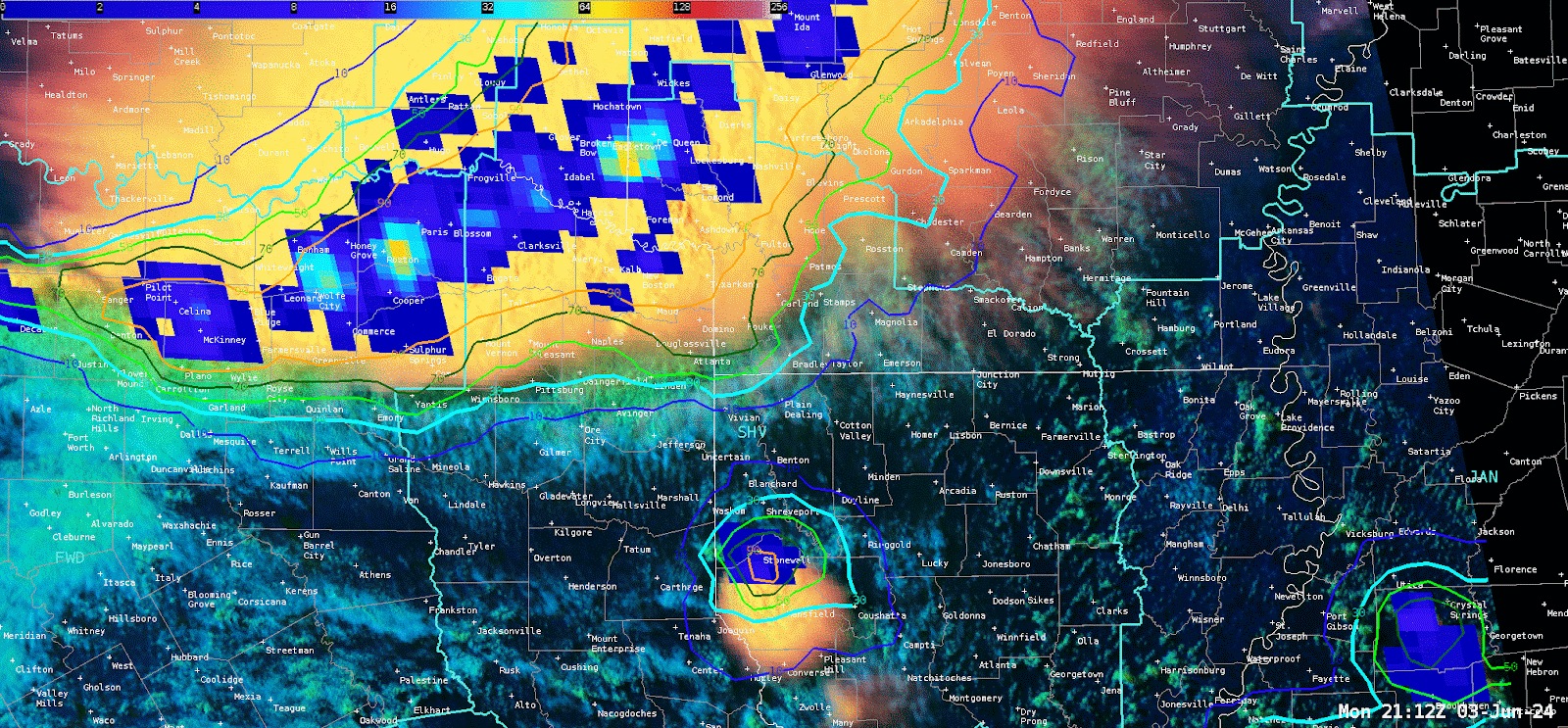
KSHV radar trends illustrate a cold-pool dominated, weak MCS approaching the NW corner of the CWA. Many satellite products illustrated a consistent mainly sub-severe weather episode unfolding giving increasing confidence in the near-term forecast and expected impacts. Focus would be on any stronger individual updrafts for potential isolated severe thunderstorm warnings.

Overall, there was high confidence in approaching thunderstorms per radar and LightningCast data pinpointed the ongoing widespread nature of the convection, given several embedded impulses of GLM spikes behind the leading southeastward surging outflow boundary:

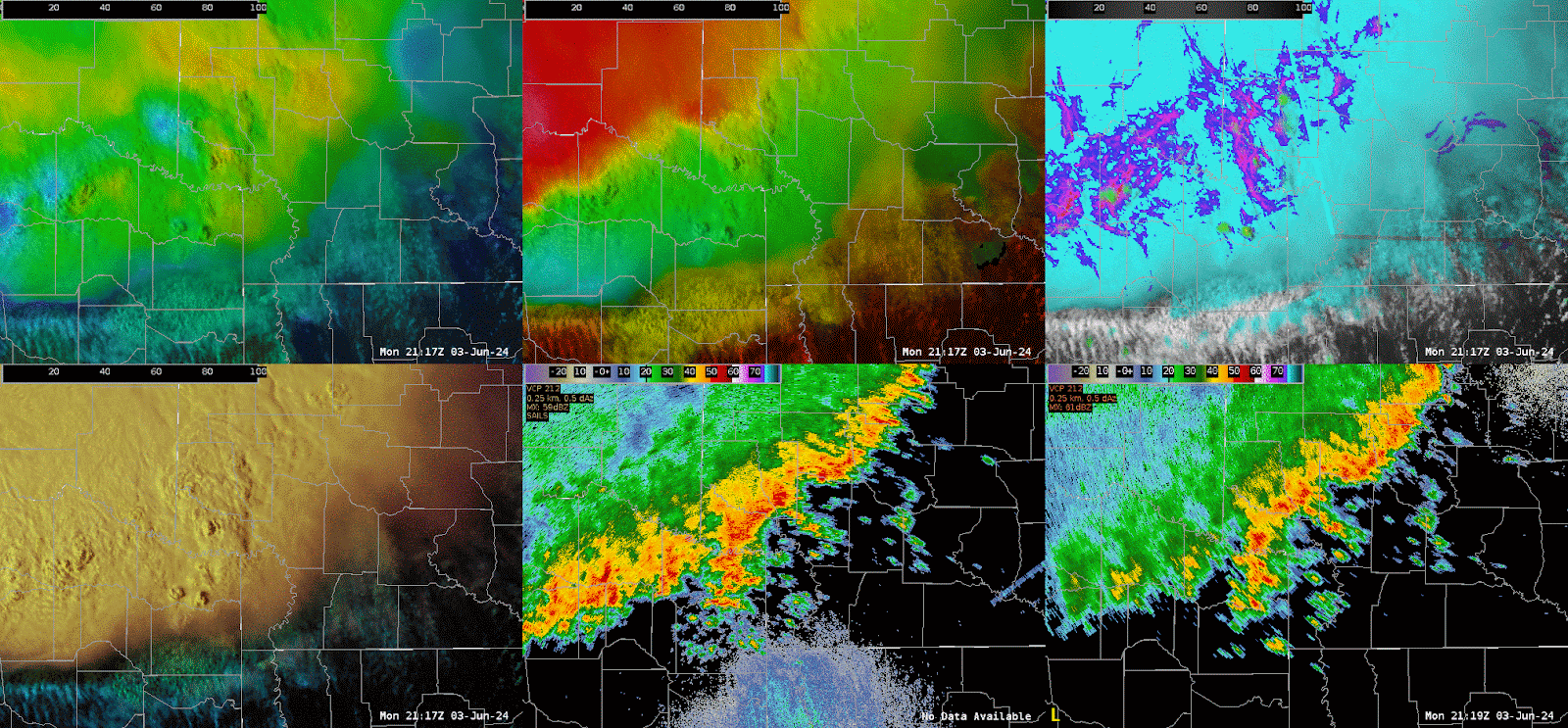
East Octane SpeedDirCTD-CTD_4Pan procedure provides more calculated parameters on top of RGB and ABI products to quickly diagnose convective strength/intensity.

The top 3 panels below (OCTANE speed, direction and Cloud-top Cooling and Divergence) identify a large-scale cirrus canopy with embedded updraft impulses.

Situational awareness was enhanced by adding on local KSHV and KLZK radar which helped to identify a SSW to NNE boundary and associated CI ahead of the main line, which OCTANE products began to illustrate (see center of each product, identifying increasing speed/directional divergence colocated to the convection along the boundary)

Given the environmental parameters, this would have been a location to examine for the potential of a severe thunderstorm warning, especially if associated radar trends (RIJ via radial velocity) indicate increasing downdraft wind potential.

– RED11248

Finding Boundaries in OCTANE Direction and Comparing to Satellite

As a forecaster, I’m most accustomed to pulse severe conditions, and I work in an area where there tends to be abundant cloud cover. So being able to find boundaries is really helpful. So I decided to review some of the low-level cumulus fields in OCTANE and looking how accurate they are compared to current derived GOES East winds. From what I sampled, they were within 5 degrees of OCTANE.
Now zooming out, we see that there will be an area of confluence in the wind field based on the low-level cu field. Further aloft, you can see some of the diffluence along the warm conveyor belt. Sometimes, wind barbs are really useful tools to assessing an environment, and I think a similar function in OCTANE could be useful for mesoanalysis.


Kadic

A Tale of Two Thunderstorms

Two thunderstorms developed with mixed signals between the variety of tools available. Satellite tools would’ve suggested that the southern storm was the area of interest, but the radar signature was much better for the northern storm. GREMLIN is shown below, with the GOES West on the left and GOES East on the right. LightningCast is contoured, and the probability of 10 flashes mainly favored the northern storm. The appearance on GREMLIN was much stronger for the southern storm.
When looking at the GLM RBG, the more frequent and shorter flashes were associated with the southern storm.

Looking at OCTANE, the southern storm appeared more impressive. Although towards the end, the northern storm began to exhibit stronger upper level divergence.


But again, if one were to look at radar, it would be readily apparent that the northern storm should be ranked as the biggest threat. In a situation involving satellite alone, I might have missed the event that did produce the severe event.

And of course remembering how significant parallax is. From GREMLIN with GOES West, my storms were neatly in their boxes, but from GOES East, it would’ve looked quite strange.


And despite the signal from satellite, the southern storm essentially collapsed in on itself. GREMLIN using GOES West does not seem to catch on to this fact, but GOES East has corrected to a stronger storm up north.


Kadic

A Tale of Two Storms From OCTANE, LightningCast, and GREMLIN


This is an interesting comparison of two storms that show two initially different satellite and LightningCast signals that produce very different results on radar. The southern cell shows an initially much more consistent cloud top divergence signal from OCTANE with a more robust looking anvil shield and an above anvil cirrus plume. That aside, the northern storm consistently had a higher probability of >10 GLM flashes from LightningCast and eventually developed a far stronger radar signature and eventual severe thunderstorm. The southern storm struggled to even develop a 40 dBZ core. The animation below shows the same progression but with the OCTANE speed and direction RGBs. In this case if a severe decision was to be made with just the satellite presentation, the wrong decision may have been made (at least initially).

-Joaq


Finally, here is how GREMLIN handled the southern storm, which it understandably initially intruduced high reflectivity to the southern storm.

-Joaq

OCTANE Trends for Ongoing Convection in ABR CWA

Taking a look at OCTANE – it seems like the IR/Nighttime data shows especially the directional details a bit more than the Visible/Daytime products. This has been a continuing trend this week. The CTD and CTC products have been useful with monitoring the strength of the storms (especially which may become severe) as well as with the newer convection/updrafts.

OCTANE – Visible (Daytime) vs IR (Nighttime)


OCTANE – Cloud Top Cooling and Cloud Top Divergence

Forecaster Cumulus

OCTANE Cloud Top Divergence and Cooling view of an Orphan Anvil


Here is a good example of the OCTANE product showing the transition from an updraft to a divergent anvil cloud, which then cuts off from the parent updraft. This “orphan” anvil is an indication of a convective initiation attempt, which can be a signal for upcoming successful initiation in the near future. The OCTANE product does well to highlight both the updraft and then the anvil in different color shades through the entire orphan anviling process.

Below is an additional animation of deepening cumulus development with the OCTANE cloud top cooling product highlighting the taller towers.

-Joaq

Comparing OCTANE Day and Night Products with KSJT Convection

Wanted to make some observations comparing the day and night versions of OCTANE with convection in the KSJT forecast area. This is at about 1837Z.


For the most part, want to compare the speed product (left side) with the storm near Taylor County (bottom left part of the image). The day version is in the top left, and the night version is in the bottom left. There is detail in the day version that does not carry through to the night version. Of note: the anvil-top cirrus (slower motions) do not show up on the night version. Also, the magnitudes of the north and south lobes of higher speeds are muted somewhat on the night version.

Also want to note that the night version of the direction product (bottom right) shows a more significant shift in direction than the day version (top right). This is most evident with the larger shield of clouds over the top right part of the field of view, where more orange colors (about 200deg) are showing up on the northwest flank than in the day version (210deg-220deg). This is also evident somewhat on the storm in the bottom left part of the image.

It was also noted that overshooting tops in the night speed product appear as dark spots, which appears to be related simply to the IR  depiction of the storm. This is not a problem, as it draws the eye to the overshooting top / strong updraft.

–Insolation

Tracking Storm Strength With GLM and OCTANE

The GLM RGB, combining flash extent density and minimum flash area, highlighted the intensity trend of a cell in the northeast corner of the FWD CWA. The yellows of the RGB also corresponded with the uptick of cloud top cooling signatures shown from the OCTANE product. Using these products together I was able to track the intensity of thunderstorm, which took another uptick towards the eastern border of the CWA. The GLM RGB is definitely a useful tool in reading both the characteristics of the flash length and the flash density.
The OCTANE cloud top divergence product here is overlaid atop the visible satellite imagery with the cloud top cooling product, which may look a little messy to look at at first glance. After some practice with the product I was able to learn to pick out both the cooling and the divergence in a strong convective cell. In the third image I did remove the divergence product to have a good look at the cloud top cooling and visible satelitte signatures. After going back to the combination of the two however I found it easy to read what was happening among both the divergence and cloud top cooling with both displayed. I did like having cloud top cooling displayed on top of the divergence product as the divergence product was broader spacially and it made more sense to have the smaller scale cooling signals pop up above the divergence display.


-Joaq

Analyzing Differences Between OCTANE IR and Visible Speed and Direction Products


A number of features appear differently on IR and visible based OCTANE products this afternoon. First, the divergence of cloud top motion really stand out on the IR products, especially on the southwest storm in SJT’s CWA. The dark blues on the upshear side as well as the contrast of the red and green directional colors really appear well on the IR. In comparison, the visible based OCTANE speed product still shows shows the upshear values with the divergence signal, though it is a bit more subtle than IR. However the visible product allows us to see other features, like the above anvil cirrus plume on the southwest storm. In the cluster of storms to the northeast where this kind of feature isn’t visible, the visible OCTANE product still shows the strong cloud top divergence. OCTANE direction from IR shows divergence aloft a bit better than the visible product, though the difference isn’t huge. Finally, the color table adjustments done today to the Octane Speed IR product really help make the divergence stand out. Cloud top divergence in these products has been pretty well correlated with thunderstorm severity, so the IR based product seems like it would be very useful, especially at night.

-Joaq