An official website of the United States government
Here’s how you know
Official websites use .gov A
.gov website belongs to an official government
organization in the United States.
Secure .gov websites use HTTPS A
lock (
) or https:// means you’ve safely connected to
the .gov website. Share sensitive information only on official,
secure websites.
Starting to see more discrete circulations that are most likely very shallow and probably too small to be well resolved at much greater range than this. The example suggests utility in having the NMDA and NTDA icons displayed together because in this situation they’re basically identifying the same features while bringing different information to the table.
For example, the NMDA is looking at the 0.5 through 1.3 cuts while the NTDA uses multiple moments (including dual pol) at the 0.5 cut and then draws upon a set of a analogs to calculate probabilities. Using the NMDA/NTDA in this fashion is sort of like using a “two model ensemble” to build confidence in detections.
Here we see multiple MDA detections along the leading edge of the convection outflow. Note that this is 0.3 degrees roughly below 1000 ft, well below the LCL:
A QLCS is moving across far northeastern Mississippi. The KGWX radar is shooting parallel to the gust front on a lengthy segment of this QLCS, which has a fairly well-defined (if not overly sharp) leading edge / shear axis. This is a case in which the NMDA is suggesting that there are multiple weak mesocyclones lined up along this shear axis, when in reality this is (mostly) just a line of forward propagating convection. At the time of this screen capture, the one NMDA detection with a higher AzShear value (in orange) does appear to be legitimately associated with a mesocyclone.
KGWX detections at 2029Z.
On the other hand, a tight circulation did develop along another QLCS segment further south, where it was intersecting the outflow from the northern segment. NTDA picked up values >50% here, and did so in advance of the circulation tightening up to the extent that it can be likely called tornadic. This was a good detection for sure.
2052Z
A weak/shallow circulation developed in Oktibbeha County MS, on a kink in the line. This feature is just to the right of the word “Oktibbeha” in the image below. However, despite there being a number of false alarms on the NTDA algorithm (including one just to the north), this feature did not generate a detection on either the NTDA or NMDA. Forecasters in our group thought that this feature, while probably unlikely to be actively producing a tornado, was probably the kind of thing you would want the algorithms (or at least the NTDA) to put some kind of small probabilities on. For the purposes of NMDA, it should be noted that this weak circulation did extend through the lowest 3 or 4 slices on KGWX.
NMDA was slow to pick up on discrete supercell development southeast of Jackson MS. Several scans later all three of these cells had a ‘medium’ to ‘high’ for AzShear Max. This may have been a latency issue or a restart of the NMDA/NTDA algorithms?
Three discrete supercells developing south and east of the main line of convection.
Multiple overlapping “low” NMDAs were observed along the leading edge of a squall line with a slightly bowed segment. Looking at SRM, aside from the northern book end, these do not appear to be anything of concern, at least not from a rotation standpoint. These very low-end detections are proving to be somewhat distracting, with the areas of stronger rotation almost hidden amongst the excessive amount of icons.
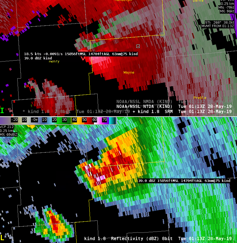
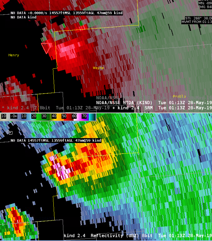
The supercell cluster coming into Wayne County, Indiana, is exhibiting solid rotation on the lowest slice. NTDA from KIND/KILN are both showing values in the 80% range. Both radars are also indicating two separate mesocyclone detections, and a qualitative analysis of the storm does suggest two separate updrafts and storm cores. As one would expect, the southern core (the newer development) is driving the NTDA detection which matches with the location of the southern NMDA detection. This makes sense conceptually, as the tornado potential will be much greater with the unimpeded inflow associated with the southern core.
KIND detections of NMDA/NTDA in NW Wayne County, Indiana.KILN detections of NMDA/NTDA in NW Wayne County, Indiana.
0157Z
A broken cluster of supercells is now entering the state of Ohio. Radar data is largely quite mottled and the majority of the NMDA detections are weak, but there are a lot of them — including in places where conceptually you would not really expect a circulation to exist. There are data artifact issues, related somewhat to the distance from the KILN radar, and also perhaps related to the complex interaction between different parts of different supercells and storm clusters. This would likely be a case where extremely weak / transient detections might be desired to be toggled off under a certain threshold. NMDA detections on the strongest circulations have not necessarily been stronger detections, but NTDA detection probabilities have been tracking fairly well with where tornadoes appear most likely to occur.
KILN detections of NMDA/NTDA at 0155Z.
0237Z
Both the NTDA and NMDA are making high-end detections in Miami County, Ohio, near West Milton. The NTDA has had values >95%, and at times >99%, with this tornado. Perhaps more interesting is that this is the first case I have yet seen in which the NMDA has shown such a consistent, high-end, well-tracked detection across a span of 10-15 minutes — with extreme (>0.03) values of AzShear. Overall, the NMDA algorithm doesn’t seem to trip into the higher values very frequently, so it really calls your attention to it when it does.
KILN detections of NMDA/NTDA at 0234Z.
0302Z
A messy storm evolution has occurred in Auglaize County, with some kind of hybrid QLCS / supercell structure based on Z/V data. Although qualitatively, the velocity data is not particularly impressive, the NTDA has done a very nice job at consistently detecting a tornadic signal from around 0241Z to 0251Z. A tornado did occur at this location, including a TDS that was apparent along the same track of the NTDA detection just a few minutes later. This is a very good detection by NTDA, correctly identifying a tornado in an area where eyeballing the velocity data would not yield as much certainty.
Now looking at ILN radar, Here we see several detections that are associated with a complex velocity pattern. The alternating inbound/outbound velocity pattern suggests gravity waves are propagating northeastward. This is in the evening, so perhaps a nocturnal inversion is helping to duct these waves. Not surprisingly the NTDA appears to have some false detections with the 2D shear.
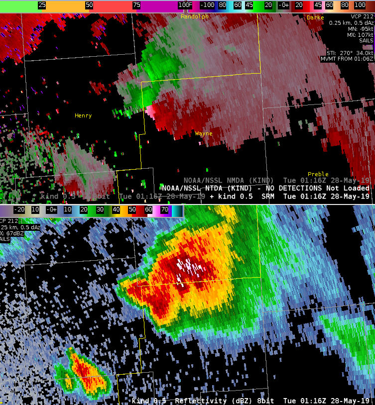
We see a case where the TDA is inconsistent in time, likely due to noisy velocity, KIND 28May2019 at 0116Z Wayne County, likely due to vertical velocity data smearing.
Velocity data smearing on the 0.5 degree tilt (likely originating fomr the 1.8 degree slice or higher).1.8 degree slice where data smearing is likely originating.
Here (below) we see the detection return and it’s impressive that it is assigned the same ID as before. This will help for creating time series of the features attributes. That’s good news. What’s less good news is we see a great setup for vertical data smearing as broad rotation with a 60+ dBZ core aloft is being aliased downward. There is no easy solution for this I’m afraid. Spectrum width is very high (>20 kt) and CC is ~ 0.8 or less so there is a possible flagl for degraded data quality. However, these values also could legitimately occur with a strong TDS.
NMDA algorithm performed well on developing and descending mesocyclone that moved eastward out of Darke County and into Miami County, which ended up producing a tornado that destroyed a house. The algorithm indicated medium strength on the meso some 20 minutes before the tornado struck the area NW of Milton, IN. The temporal resolution from time step to time step gave me higher confidence that a strengthening meso was in progress.
Mesocyclone strengthening across SE Darke County eventually produced a tornado in SW Miami County. Values on the NMDA were in the ‘extreme’ range just before the reported tornado.
NTDA performs well in mature supercell over ern IN. First time of detection to current time of detection over 1 hour indicative of long track of cell. Probs were over 90% for quite a few scans. Overlaid with prob severe, it is nice to see meso environment that the cell is embedded in.
Would be good to see some environmental data embedded in the algorithm to keep the screen less cluttered. Also, a total time of detection will be a good addition to the readout table.


 -marfafront