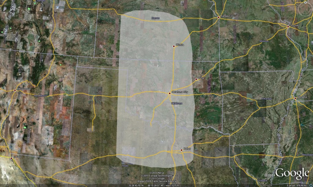
11 May 2011: Initial Area Forecast Discussion

AREA FORECAST DISCUSSION

  • A closed low will move from the Four Corners area to the north-northeast through the afternoon and evening.  A short wave trough rounding the base of the closed low will track from southern NM into the OK/TX panhandles this afternoon.  The largest height falls are forecast from the panhandles into western KS, with weaker forcing extending farther east.
  • RUC forecasts MLCAPE in the 2000-3000 J/kg range east of the dryline.  Sufficient deep layer shear to support severe thunderstorm development should be in place by early afternoon.  Via a combination of surface heating and increasing large scale forcing for lift, the cap is expected to weaken enough to allow for thunderstorm formation.
  • Our area of focus was chosen considering not only the potential for severe convective storms, but also the availability of lightning data and OUN WRF data over Oklahoma.
  • Afternoon thunderstorm development is conditional, depending to a large extent on the evolution of ongoing thunderstorms over central OK and north TX.  Further thunderstorms developing in between these two areas could decrease instability by limiting moisture advection and surface heating.
  • Top four choices for CWAs of focus:
  1. OUN
  2. ICT
  3. DDC
  4. FWD

Billings/Taylor/Vincent

Tags: None

Live Blog – 17 June 2010 (7:30pm)

The tornado outbreak continues.  Our MPX WFO has been removed of a forecaster to do the archive case, so Jordan has stepped in to help.  We also continue with two mets on FGF. Significant tornadoes with damage have been reported in both CWAs.  One storm in particular near Albert Lea MN is a beast.  Our forecasters are doing a great job keeping up with the threats.  Later, we will compare their warning polygons with the official warning polygons.  Previews by the coordinators indicate there are major differences!

Greg Stumpf (EWP Weekly Coordinator, 14-18 June 2010)

Tags: None

Live Blog – 17 June 2010 (6:35pm)

Wow!  Been so busy, forgot to make a live blog post.  We have been working the tornado outbreak event as WFOs Minneapolis MN (MPX) and Grand Forks ND (FGF).  In the early part of the afternoon, we had two forecasters working MPX and the other two on the 5/24/08 archive case.  Greg Stumpf (Ops Coord.) decided to work the FGF himself, and was quite overwhelmed, but managed to issue a number of TORs on the storms there.  Isolated storms ahead of the dryline, as well as a line of tornadic storms on the dryline!  Here is a current picture of our active experimental warnings (NOTE:  These are unofficial warnings!).  On the left – multi-radar MESH (Max Exp. Hail Size).  On the right – 30 minute rotation tracks.

Greg Stumpf (EWP Weekly Coordinator, 14-18 June 2010)

Tags: None

Live Blog – 16 June 2010 (6:55pm)

OK – we just switched out LWX team to Rapid City SD (UDX) since the Virginia convection is petering out.  Several nice supercells are ongoing in the Rapid City area.

Meanwhile, our CTP team is now doing the 5/24/08 Oklahoma archive case.

Greg Stumpf (EWP Weekly Coordinator, 14-18 June 2010)


Tags: None

Live Blog – 16 June 2010 (6:05pm)

Our notification problems would not go away for two of our four workstations, the two running State College CWA.  Since that CWA was remaining quiet, we decided to move those two forecasters over to the Oklahoma LMA archive case for the remainder of the evening.

Our Sterling CWA team has had no workstation issues, and has been issuing on the order of 6-7 SVR warnings today.  However, it appears that the few storms are winding down and moving out of their CWA. The SPC never issued a watch for this area, despite the warnings (presumably – haven’t looked at the official warnings yet), and the 5% Tornado Risk in the 2000 UTC DY1 outlook.

For the evening, we may find them another CWA to operate, either State College (storms beginning to pick up to their west), or move to one of the High Plains locations.

Greg Stumpf (EWP Weekly Coordinator, 14-18 June 2010)

Tags: None

Live Blog – 16 June 2010 (5:15pm)

Ugh!  Notifications on AWIPS break again, and it takes us about 45 minutes to get them working again.  The fragile system continues to move along for now.

But in the meantime, we’ve been working two CWAs:  Sterling (LWX) and State College (CTP).  Only our LWX folks have been issuing warnings, SVRs, mainly for wind severe criteria wind (60 mph).  The LMA data has been used as well.  CI detections have been outside of both CWAs.

Greg Stumpf (EWP Weekly Coordinator, 14-18 June 2010)

Tags: None

Live Blog – 15 June 2010 (7:40pm)

Getting ready to wrap up operations tonight.  Currently, IND is winding down with the remnants of the advancing squall line/mcs in the NE part of their domain.  LMK transitioned from isolated storms in the eastern CWA to the squall line in their western CWA.  The isolated storms were “handed off” to ILN and warnings continue on them.  So far, these storms have only produced hail and wind reports, with the most being an 82 mph gust measured.  One brief tornado was reported early on the IND storms.

Our forecasters are starting to fill out both the GOES-R and MRMS surveys, and we’ll do a replay of their warnings along with the NWS warnings to finish the shift.

Greg Stumpf (EWP Weekly Coordinator, 14-18 June 2010)

Tags: None

Live Blog – 15 June 2010 (6:50pm)

Around 615, we switched the PAH WFO to ILN (Wilmington OH), as the isolated supercells ahead of the line were starting to come into the western edge of their CWA.  We have several isolated supercells out ahead that IND has issued several TORs, as well as a rapidly advancing squall line surging behind the supercells.

Greg Stumpf (EWP Weekly Coordinator, 14-18 June 2010)

Tags: None

Live Blog – 15 June 2010 (5:25pm)

We continue with an IND and PAH setup, but we might break one of the forecasters away from PAH to cover LMK.

IND has now issued a TOR on a new supercell to the east of the previously TORed storm.  Velocity is nt the greatest, but the reflectivity data shows a nice dBZ “ball” on the tip of the hook.

Greg Stumpf (EWP Weekly Coordinator, 14-18 June 2010)

Tags: None