
HRRR output painted the merging of the ongoing line of non-severe storms and new initiation ahead of this line. CI and CTC showed an evidence of early convective initiation though lead time near 30 minutes. nunez


Official websites use .gov
A
.gov website belongs to an official government
organization in the United States.
Secure .gov websites use HTTPS
A
lock (
) or https:// means you’ve safely connected to
the .gov website. Share sensitive information only on official,
secure websites.

Real-time posts made during testbed nowcast and warning operations.
HRRR output painted the merging of the ongoing line of non-severe storms and new initiation ahead of this line. CI and CTC showed an evidence of early convective initiation though lead time near 30 minutes. nunez
Our EWP2012 debriefing today. From my iPad.

Greg Stumpf, EWP2012 Week #1 Coordinator
MRMS echo tops data depicted signals associated with a t-storm with hail. Strong signals are depicted at 0046Z at the 18 dbz and 30 dbz levels (lower left and lower right) with smaller signals noted at the 50 dbz and 60 dbz levels (upper left and upper right). Although the signals at the 50 dbz and 60 dbz levels are small in area, they represent 50 dbz to 32 kft and 60 dbz to 26 kft which are significant levels for severe hail.

AMS
23Z GOES nearcast for 01Z supports strong updraft potential for the Brewster county storms. Legacy Hail algorithm maintained 2 inch potential for a couple scans, so the potential for severe size hail is likely to continue. This hail threat should continue through 03Z. EMs and other decision makers should continue to monitor for potential warnings and statements.

Not a whole lot going on this evening. However, 3D VAR (see image below) still depicting weak signals of updraft (upper left) and vorticity (lower left) with a garden variety t-storm west of Longfellow, TX (reflectivity in the upper right).

AMS
Because storms near EPZ have gone below severe limits, we’ve moved our EPZ folks to WFO MAF to work some storms in the Big Bend area.
Because the BRO storms have moved offshore, or are staying in Mexico, we’ve moved our BRO folks to Florida. One is working JAX (recent “real” warning issued there), and one working MLB (PGLM data possibilities).
Otherwise, things are getting rather quiet across the nation, and we still have until 9pm! We’ll be done at 815 however to start feedback surveys.
Greg Stumpf, EWP2012 Week #1 Coordinator
thunderstorm activity has diminished across the forecast area and the environment favored multicell organization. main impact will be heavy rain with isolated storms creating 1/2 inch at most based on latest hail algorithm trends. HRRR composite reflectivity supports this trend during the next 1-2 hours while the effects of daytime heating remain.
3DVAR maximum updraft intensity (2-hour) versus MR/MS Max Expected Size of Hail (2-hour) for the tornado-warned storm in the Brownsville CWA. Max MESH frequently follows the peak updraft intensity in storms that produce large hail.

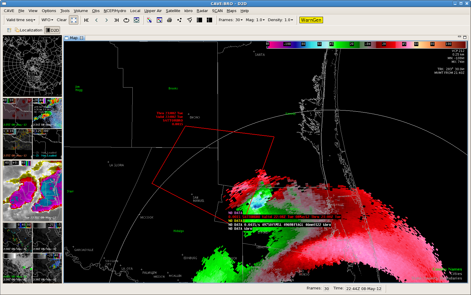
Severe/possibly tornadic thunderstorm…currently located over northern Mexico west of BRO…has been showing an increasing trend. Updraft helicity have have increased to 87 m/s2 with surface vorticity values to 16 s-1. It appears a rear flank downdraft has now developed on the south side of the storm. Hovis/Barnes

