Houston CWA May 6th event

 Started out issuing a warning for parts of northwest Houston’s area based on info from the Flash density product.

3:06 PM. Using Octane, noticing a cluster of convection that is developing and becoming more interesting for warning purposes.

3:38 PM Severe Tstorm with tornado warning out. Special feature noted on Octane Speed Product where the updraft was reisting ambient wind flow as the storm intensified noted by cyan colors on LA/TX state line near Shreveport.

-Jolly Rogers

Tags: None

Comparison of GREMLIN, OCTANE, and Radar Products For Two Storms near KMAF

Something interesting was noted when looking at two nearby storms on 05/06 between 2146Z through about 2205Z. When looking at two thunderstorms which quickly fired up near the MAF radar, OCTANE STD data suggested the storm to the left had stronger divergence aloft. The OCTANE Speed Sandwich also showed these storms were relatively similar in strength with the right storm having slightly stronger shear, but decided to look at GREMLIN and dual-pol radar data for further analysis. It is worth noting that OCTANE data stopped coming in around 2146Z due to a power outage at CIRA. GREMLIN data clearly showed the left storm was weaker depicting much lower reflectivity. This overall aligned with MRMS data, but the GREMLIN data did smooth out higher Z values as expected. 88D radar data was then used to help investigate the two storms after seeing both OCTANE STD and GREMLIN data differ on which storm was more intense. When looking at radar data it became clear that the storm on the right was more intense with a BWER, higher cloud tops, more intense reflectivity core aloft, and stronger STD (wasn’t able to sample true STD because the storm was too close to the radar).

It was very odd to see the left storm had stronger divergence aloft in the OCTANE STD procedure yet all other data suggested the storm on the right was much more organized. There are no loops in this blog, but the weaker left storm was a left mover while the stronger thunderstorm was more of a right mover. Could this have played a role in the OCTANE STD data suggesting the left storm was more organized?

A severe thunderstorm warning was issued on the right storm before these comparisons were made as it was evident a supercell was developing. OCTANE/GREMLIN aided in quickly seeing where CI was occurring and which storms were intensifying quickly. However, using the satellite products alone to issue warnings would have been difficult. This could be due to not being familiar with what thresholds forecasters need to be looking for in OCTANE or GREMLIN in order to issue a warning. If I were in a forecast office with radar holes or beam blockage, these new satellite products would still be very helpful to interrogate storms. OCTANE/GREMLIN provided better confidence on what storms to focus on and paired well with 88D radar data for warning operations. It would be fascinating to see how this works in a location where there is beam blockage or radar holes.  

When looking at this 4 panel OCTANE STD suggests the cell on the left has stronger divergence aloft. The speed sandwich (top left) suggests the storms are relatively similar in intensity though slightly stronger shear was evident for the right storm.

The two storms on the right are the ones of interest. Ignore the far left storm. GREMLIN data clearly shows that of the storms in question, the one on the right is more intense as reflectivity values are much higher. OCTANE data went out at 2146Z so timing between products is off slightly. GREMLIN data compare to MRMS data as both showed the storm on left being less organized. MRMS was a lot easier to read though due to less smoothing.

88D Radar data clearly shows the storm on the right is more organized with a BWER, higher cloud tops, much stronger reflectivity core aloft, and stronger STD (true STD could not be sampled as the storm was very close to the radar).

– Ricky Bobby

Tags: None

First Use of GREMLIN in Warning Scenario

My first time experimenting with GREMLIN, I was able to utilize it briefly during a warning scenario.  Using the 4-panel (Figure 1) below in conjunction with radar data (KFDX), I issued a Severe Thunderstorm Warning for 60 mph winds (Figure 2).  Other than the fact this storm previously had warnings, the velocity/SRM signature was decent (certainly no slam dunk) for straight-line winds, but the uptick in GREMLIN Meso-1 combined with the increase in cloud top cooling south of Fort Sumner. Figure 3 shows a 3 minute difference showing the rapid uptick in the GREMLIN radar emulation. The CONUS radar emulation did show it, but in a warning scenario was a bit too delayed to use with any confidence to issue a warning based on its data.  It certainly helped solidify the decision after issuing the warning.

Figure 1: East Meso Sector GREMLIN and Channel 13 (left side), MRMS composite reflectivity and East CONUS GREMLIN (right side).

Figure 2: Severe Thunderstorm Warning in southeast portion of ABQ CWA.

Figure 3: The radar emulation from East Meso-sector 1 (top left) shows a nice uptick within 3 minutes with the storm south of Fort Sumner and from the previous loop from Figure 1, it continues for several more minutes. Thus, added confidence to issue a warning by 21:21z.

– Podium

Tags: None

Storm-Scale Environmental Analysis of Early Convective Development

This case at WFO OUN brought forth a challenging situation monitoring developing severe weather with no available radar data, and only relying on satellite products for storm interrogation and convective warning decisions. This analysis will primarily focus on the evolution of early convective development and how satellite products/PSH data helped gain a better understanding of the environment.

My role in the team monitoring/analyzing the environment was focused on issuing warnings and having the Mesoanalyst(s) relay satellite, PSH and GREMLIN information to support warning decisions. To prepare and gather a greater situational awareness of the environment and what satellite was observing, I loaded in RAP13 Right/Left Bunkers vectors which would aid me in effective polygon design. Given the orientation of the hodograph per observed soundings earlier, storms would support the potential for left/right splitters meaning proper storm motion/polygon flare is very important.
Convective initiation began around 21-22Z with noticeable towering Cu across Cotton County, OK, prompting the first issuance of a SVR at 21:56Z given cooling cloud tops/increasing storm top divergence.

Towards the end of the loop above, observation was made that the overshooting tops were turning more ENE biasing closer to the bunkers right, implying the likelihood of the storm developing a mesocyclone. Not shown here, but a useful trick of enhancing the contrast of the Day Cloud Phase RGB became extremely useful in tracking overshooting top motion and intensity, along with other satellite products diagnosing an intense updraft in progress.

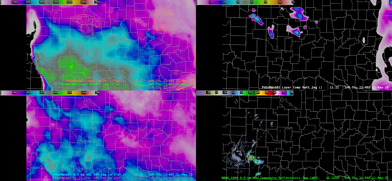
The pre-storm environment was analyzed using PHS data, highlight ample MUCAPE on the order of 3500-4500J/kg around the area of CI,  and large-scale 0-3km SRH ranging around 250-350m2/s2, bringing support for stronger/severe storms to attain rotation in a volatile, highly unstable/moderately sheared environment.
WIth the storm obtaining a developing/intensifying left splitting  updraft (later in the first loop), confidence of a strengthening mid-level mesocyclone increased leading to a transition to a base TOR warning, with polygon design mainly following the bunkers right motion vector to imply near-term motion to continue ENE.
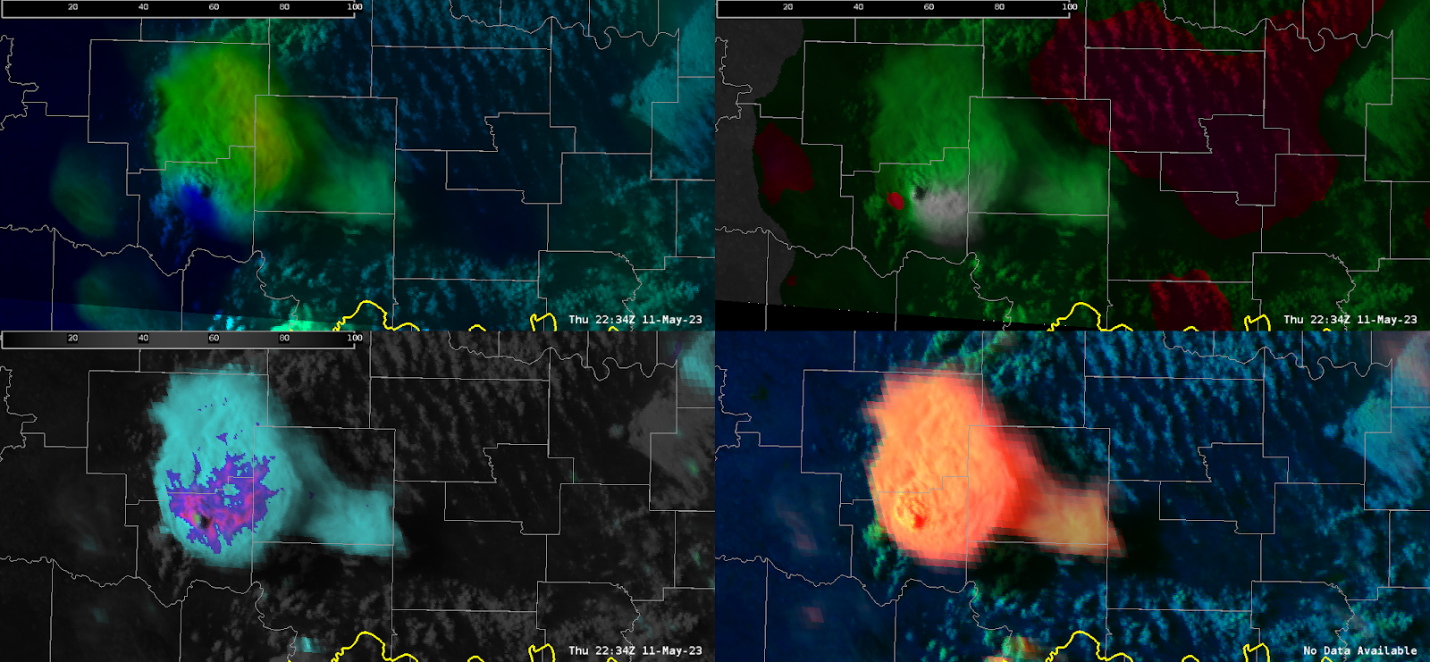
Modifying the OCTANE speed product by decreasing the max observed values downward and min values upwards helped diagnose a more eye turning signature to storm top divergence. Additionally, modifying the direction scale, albeit took some work, came out with a product that illustrates (in red) backed sfc winds <`180 degrees which existed well ahead of it, inferring the likelihood of larger curved hodographs and greater attendant estimated low-level SRH.

However, one item that was not noticed until after the TOR warning was the winds being ingested into the storm (shown in green) averaged around 210-230. This appeared very accurate looking at feeder cumulus ingesting into the inflow region of the cell just to the SSW. Less backing of the surface winds yields much less available streamwise vorticity (in fact is mainly crosswise) leading to the likely reason the storms rotation did not strengthen, and ultimately collapsed 30 minutes after the image above and the left-turning supercell became the dominant storm.

Overall, OCTANE exhibited great, practical uses to understanding not just the storm intensity/trends but the environment explaining why the storm was behaving the way it did.

– RED11248

Tags: None

Comparing GREMLIN and LightningCast to actual Reflectivity and ENTLN Lightning Plots

Radar is an essential tool used across all CWA’s daily. What would you do if your CWA had the potential for severe weather but you did not have radar or MRMS? Well that is something I was able to experience today across KOUN’s CWA. Satellite convective products such as GREMLIN and LightningCast were crucial in being able to determine storm location and intensity. GREMLIN was helpful in being able to get an idea of the location of storms along with their intensity even though the range of reflectivity with GREMLIN is limited. The general idea was to see if there were any areas with high end reflectivity near 50 dbz as that usually indicated an area of stronger storms. If there were any areas with lesser values this may mean developing storms that could be checked with LightningCast data to see if it believes storm development is likely to occur there. Speaking of LightningCast it was very useful in determining locations of possible future storm development. Using the >1 strikes within the next 60 mins really helps highlight areas of potential storm development and motion. When comparing these products to actual reflectivity there are a few things that stand out. The first being a good ability to get a general idea of potential strong storms and future storm development. Both products highlighted about the same area where the actual reflectivity was located and where lightning clusters developed.

\

These products were then able to do a good job in picking up the intensifying storms and their likely future location. This was shown from data taken at around 23Z.

Overall, both of these products were extremely useful and successful when it came to forecasting severe thunderstorms in a scenario where radar was not available. I can most definitely see these products being applied to everyday convective ops at CWA’s across the CONUS. The last two images show the 00Z comparison between GREMLIN and actual radar reflectivity.

– Sven The Puffin

Tags: None

Application of Octane, LightningCast and GREMLIN across western Maine

Maine has an overall weaker radar coverage compared to many other CWA’s across the CONUS. This made it a great place to test out some satellite convective products such as Octane, LightningCast, and GREMLIN. The first image shows the confidence of LightningCast in the development of thunderstorms across parts of north central Maine. Shading shows >75% confidence of seeing 1 or more lightning strikes within the next hour. This was supported by Octane, which showed increased cloud cooling occurring over this area along with large areas of cloud top divergence. What happened nearly an hour later was for the most part on point. GREMLIN and reflectivity showed patchy storms developing across the region; this was also shown on ENTLN lightning plots. GREMLIN did a great job of highlighting the stronger storms with higher reflectivity although those were lower than the actual reflectivity. The lightning plots showed large clusters of lightning, which was nearly identical to where LightningCast had drawn contours nearly an hour before. Overall, the use of all these products together in my opinion would greatly improve convective forecasting as I feel they work great together. This was once again shown today across Maine by highlighting areas with potential convective development and eventual patches of high density lightning strikes.

-Sven The Puffin

Tags: None

Tracking convection across DLH CWA with Octane, LightningCast, and GREMLIN

Forecasting in DLH today was challenging due to the radar being made unavailable. However, some of the satellite convective products were able to create accurate forecasts regarding the location of storms and lightning. Firstly, looking at Lightningcast there were gradients of ~25% appearing 1 hour out around the DSS point indicating the possibility of lightning developing within the next hour. This was also supported by Octane, which was showing storms initiating to the south with early signals of cloud top cooling and divergence occurring. Around 1 hour later this seemed to mostly come to fruition, which can be seen on the 4 panel image with GRMLN data on it. Lightning seemed to be mainly concentrated east of the DSS point which was shown in lightningcast. Also these storms originated from the south which Octane began to hint on early out. Overall, it looks as if all three of these satellite convective products did a good job in forecasting possible convection without the use of a radar.

-Sven The Puffin

Tags: None

THE TALE OF TWO GUIDANCE SYSTEMS

THE PHS MODEL GUIDANCE has had difficulty providing an accurate near term forecast with respect to the purely linear mode to the MCS as it moves east into the Texarkana region. This is most noticeable with respect to the southern portion of the linear convection. This can be seen easily below with the 3 hr forecast (in the image below) is the top panel of the image. The composite reflectivity (considered verification) is the bottom panel of the image.

THE GREMLIN MACHINE LEARNING GUIDANCE on the other hand has performed very well with the linear MCS in the near terms, along with other convection further downstream to the east. In the images below Gremlin is the top image and MRMS (considered verification) is the bottom image.

5454wx

Tags: None

A Tale of Two Thunderstorms

Two thunderstorms developed with mixed signals between the variety of tools available. Satellite tools would’ve suggested that the southern storm was the area of interest, but the radar signature was much better for the northern storm. GREMLIN is shown below, with the GOES West on the left and GOES East on the right. LightningCast is contoured, and the probability of 10 flashes mainly favored the northern storm. The appearance on GREMLIN was much stronger for the southern storm.
When looking at the GLM RBG, the more frequent and shorter flashes were associated with the southern storm.

Looking at OCTANE, the southern storm appeared more impressive. Although towards the end, the northern storm began to exhibit stronger upper level divergence.


But again, if one were to look at radar, it would be readily apparent that the northern storm should be ranked as the biggest threat. In a situation involving satellite alone, I might have missed the event that did produce the severe event.

And of course remembering how significant parallax is. From GREMLIN with GOES West, my storms were neatly in their boxes, but from GOES East, it would’ve looked quite strange.


And despite the signal from satellite, the southern storm essentially collapsed in on itself. GREMLIN using GOES West does not seem to catch on to this fact, but GOES East has corrected to a stronger storm up north.


Kadic

Tags: None

A Tale of Two Storms From OCTANE, LightningCast, and GREMLIN


This is an interesting comparison of two storms that show two initially different satellite and LightningCast signals that produce very different results on radar. The southern cell shows an initially much more consistent cloud top divergence signal from OCTANE with a more robust looking anvil shield and an above anvil cirrus plume. That aside, the northern storm consistently had a higher probability of >10 GLM flashes from LightningCast and eventually developed a far stronger radar signature and eventual severe thunderstorm. The southern storm struggled to even develop a 40 dBZ core. The animation below shows the same progression but with the OCTANE speed and direction RGBs. In this case if a severe decision was to be made with just the satellite presentation, the wrong decision may have been made (at least initially).

-Joaq


Finally, here is how GREMLIN handled the southern storm, which it understandably initially intruduced high reflectivity to the southern storm.

-Joaq

Tags: None