Boston Outlook for this afternoon/evening

At 17 UTC 9 June 2015 GOES-R LAP Alg 400-500 J/kg CAPE seems in line with SPC.  GOES-R LAP PW  1.4″ of PW highest in the NW part of our CWA.  GOES-R LI showing -1 to -3 with TT values in the upper 40s. KI are rather high around 34 for southern New England.  SPC mesoanalysis shows 30 kt of 0-6km effective bulk shear.

.GOES-RLAP9Jun2015

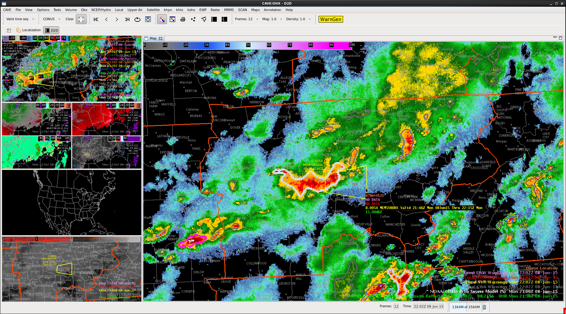
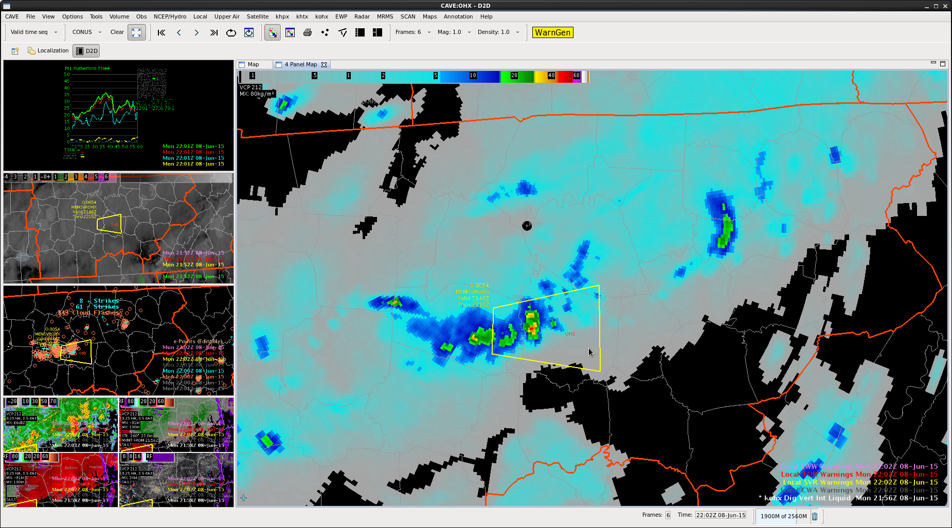
SRSO vis showing development on eastern side of upper level trof through 1837 UTC and showed a hole in the clouds developing west of ALB and just behind the main convection.  Also shows cooling tops at the S edge of the line in ALYs area.

CI products showing some 40-60% with up to 79% in SW CT, so expecting cells to strengthen as the line moves in to ALY area then in to western part of BOX.

BOXCI

MrSnow/inthecards

Tags: None

Meso Discussion Charley

Watching the southern half of the Albany CWA.  Line of scattered to numerous storms roughly bisecting this region. They are moving into a more moist airmass as they head east.  Latest visible satellite has a clear pocket ahead of these storms, so would expect them to maintain intensity.  Latest SPC mesoanalysis has a bullseye of higher bulk shear in this area, so will be watching for bowing segments and potential damaging wind gusts as these cells head northeast.  Surface-based CAPE not too impressive though, with readings around 1000 and DCAPEs are around 600.

CI showing some new development in the southeast.  Focus for now will be on the line of storms in the northern half of my area.

Tags: None

Charley…Most Useful Products Today

Overall with the pattern in place it seemed the DVIL and ProbSevere helped me to make warning decisions more than other products.  I used base velocity for a few of the SPS/warning decisions.  DVIL and clusters of total lightning helped focus on the stronger storms.  However there were several storms that we issued on with lower lightning data.  In particular the cell over Williamson county did not have a lot of lightning with it, but it did produce several reports of hail…and we later learned it had some wind damage as well.

We had some hiccups with the SRS satellite data not coming in.

Lightning time series data were not as difficult to work with as I anticipated.  I would expect a problem though if I had more than one storm to focus on.  Perhaps with experience that will get easier.  It was straight-forward to understand when cells falsely jumped in lightning data, but because of cell mergers.

Tags: None

Current Set-up

We’ve got 3 SVRs in the PHI WFO right now; however, we’ve had to rely on public reports and typical Z/V data. There is not much lightning with these storms and the ProbSevere model is only at 4%, despite history of wind reports up to 80mph.0608-2312

-BT

Tags: None

How about this? LJ Time Series Pop Up

Remember the Pop up SkewT?  You load it and mouse over the map and get a SkewT from an observed or model sounding at any point (see image).  How about the same functionality for the Lightning Jump algorithm time series?  Imagine this.  Right click a cell and pick Pop up LJ TimeSeries, then just mouse-over the cell of interest. The current method of generating the time series through the use of points and menu choices is a bit cumbersome. MrSnow/Wacha

PopupTimeSeries

Tags: None

Stewart County Warning

svr_stewart_5

Noticed more storms forming near the KY/TN border near the NW corner of Nashville CWA. The lightning jump alerted us early with a sigma of 6 that this was a storm that needed to be monitored with more interrogation below we decided to warn on this storm.

svr_stewart svr_stewart_3 svr_stewart_2 svr_stewart_4 svr_stewart_6

Tags: None

No Severe Montgomery County

A lone cell is coming in from the northwest.  ProbSevere is high for this area, DVIL relatively high.  Reflectivity aloft is ticking up though.  Close to a severe.  Low-level tilts had shown the hail all melting at the base, but starting to have a mix.  Issued an SPS for dime-sized hail.

nosvr_mont7 nosvr_mont_1 nosvr_mont_2 nosvr_mont_3 nosvr_mont_4 nosvr_mont_5 nosvr_mont_6

Tags: None

MESH says hail, reports tell a different story

Below is an image of the MESH accumulated tracks over the last 2hrs for the CTP CWA. Severe Thunderstorm Warnings were issued, mentioning both hail and wind potential, but only the wind threat came to fruition. There were at least 4 locations where the MESH was over 1″ and in one case, it approached 2″. Reports of hail can be finicky, as maybe the larger hail fell in an area where no one lives/travels. The only report of hail that we received out of all of the warnings was pea sized in northern Perry County, PA.

MESH

-Shasta

Tags: None

Severe Putnam County

Used more reflectivity and velocity base products here.  Had a good signal for wind and bowing line.  Area moving into a little higher CAPE from the GOES Sounder.  Lightning data not impressive here.  Same with DVIL and lightning jump.  No overshooting top in that area either.

svr_putnam svr_putnam8 svr_putnam_2 svr_putnam_4 svr_putnam_5 svr_putnam_6 svr_putnam_7 svr_putnam)3

svr_putnam_9

SPC Mesoanalysis page did have a maximum for the Craven/Brooks Sig Severe right over where this cell was.

Tags: None

PNGA/lightning data on Warned storm Williamson Co

pgna

We were debating on whether or not to reissue a warning on storm and noticed that the PGNA product was showing an increase in total lightning and decided on issuing.

new_svr_will_3 new_svr_will_1


The time series product also showed an increase right before we re-warned…but quickly began to tail off again after we re-issued.

new_svr_will_2

Tags: None