SVR issued for Oldham county. 3- body scatter spike evident. MRMS MESH showed 2.20 inches. Areas of strong SRMs have been disorganized so far. Updraft helicity near 200 m/s^2. Quarter sized hail reported.
HIRSCH
Thunderstorm cold pools over far eastern NM appear to be consolidating into a forward propagating MCS between 00-01z on 5/22. This was advertised fairly well by the OUNWRF earlier this afternoon.
Per regional radar loop, MCS over far eastern NM appears to be developing on MCV. Latest 5/22 00z OUNWRF is picking up on this, and continues the MCS/MCV well into the evening southeast through LUB CWA.
A rotating wall cloud/small funnel cloud was reported at 22:22z with the storm over southern Colfax county. Fifteen-minutes prior to report the following parameters increased somewhat dramatically: max divergence above 8 km (upper right), composite max updraft speed (lower right), and mid-level vorticity (lower left). Attached is the 2215z image, about 7 minutes prior to the report. 
Recall WFO Amarillo’s prior post referring to the OUNWRF’s convective initiation in the SW parts of the CWA by around 2130Z? Let’s take a look at what actually happened.

Looks like the OUNWRF was a bit too quick to develop convection over WFO AMA. We did see some very weak Cloud Top Cooling (CTC) on the order of nearly ~4C/15min near the Oldham/Deaf Smith county line for a brief period but this diminished quickly. Notice that the UAH Convective Initiation (CI) in the top left panel showed that the potential for development was elsewhere. Note…these initial showers which triggered the weak CTC rates weakened pretty rapidly.

It appears the OUNWRF may have been a bit too bullish on convective development ahead of the activity moving out of New Mexico in the NW flow aloft this evening, but stay tuned.–Gordon Strassberg/Matt Hirsch–WFO Amarillo Team.
Here’s a comparison of the UW-CTC product using the default AWIPS 2 color table (bottom right) vs. a warm to cold color table (upper right). In the upper right image the stronger cloud top cooling rates are displayed as a warmer color, similar to IR satellite color table enhancements that display the colder cloud top temperatures with warmer colors. This has the benefit of drawing the attention of forecasters who are conditions to associate warmer colors with more extreme values (ie, radar data).
GOES 20z simulate satellite on 5/21 indicates deep moist convection breaking out over western OK and portions of northwest TX (above two images…20 hour forecast). This is optimistic compared to 20z IR/WV (bottom two images). However, convection over NM is verifying nicely. Maybe simulated satellite handles orographically forced convection better?
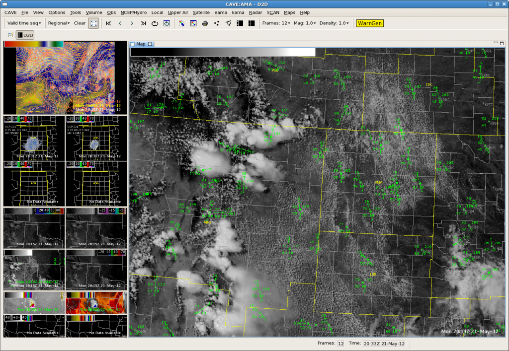
OUNWRF is forecasting convective initiation over western half of LUB CWA by 2130-2145z on 5/21 in zone of moderate instability and weakening cap. However, latest UAH CI product and UW CTC product alongside flat looking cumulus fields per visible satellite imagery would suggest convective initiation may not occur. This is also supported by seemingly meager convergence per METAR OBS. Main show may be confined to activity eventually diving southeast out of NM. Will be interesting to see how things play out.
Here we are focusing on the forecast for WFO Amarillo. First, let’s look at current conditions:

With temp/dewpoint spreads approaching 25ºF, the potential for strong downburst winds seems to be the biggest threat with developing convection this afternoon. This is supported by NAM12km forecast soundings which exhibit somewhat inverted-v profiles in the low levels around 21Z. Focus on SW parts of the CWA. There are a few NNW-SSE bands of developing TCU. Now let’s look at the 19Z OUNWRF forecast:

Indeed, if we look at the 19Z OUNWRF forecast, a few cells should initiate in the vicinity of these TCU lines mentioned above by ~2130Z (top left panel). It also shows developing outflow/downburst winds with these cells, though the model forecast does not indicate severe wind gusts quite yet (lower left panel).–Gordon Strassberg/Matt Hirsch–WFO Amarillo Team
Small area of cumulus developing over higher terrain in west Texas shows high strength of signal value on the UAH CI product at 1730z:
This area continued to develop into a mature CB, with the first cloud to ground lightning detected by NLDN at 1945z – a 2 hour lead time from the first CI signal to the initial cloud to ground lighting activity.