Daily Summary – 26 May 2010

Split IOPs again today.  For the first half of the day, we had two forecasters go through the archive case, while the other two did a real-time IOP over Oklahoma, which two other forecaster issued warning for mainly hail.  In the evening, we did our IOP on the Front Range, for Denver/Boulder and Cheyenne.

The GOES-R focus for the day was on the archive case pseudo-GLM data.  More info can be found on the GOES-R HWT Blog here and here.

The MRMS comments for the day included over estimation of hail sizes for the Oklahoma storms, but slight underestimates on the Front Range storms.  Otherwise, the forecasters are becoming more comfortable with using the MRMS products.

Greg Stumpf (EWP2010 Operations Coordinator)

Tags: None

Live Blog – 26 May 2010 (6:30pm)

Great suggestion for a MRMS “diagnostic” product from the WFO participants:  For each grid point, be able to determine which radars are contributing, what weighting factors are being used, and how many samples and at which heights are used for that grid point.

Greg Stumpf (MRMS Principle Scientist)

Tags: None

Live Blog – 26 May 2010 (6:07pm)

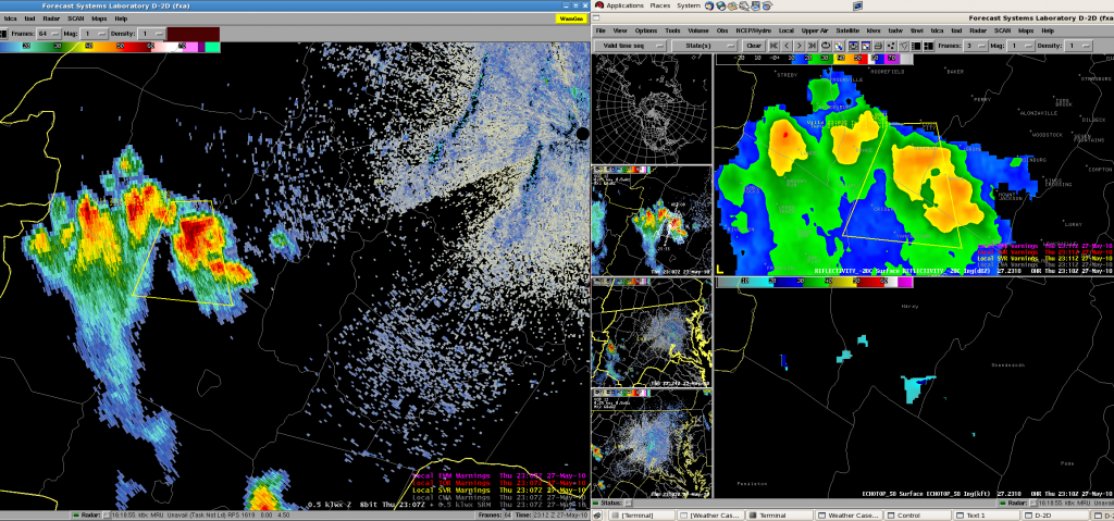
After a few hours of ops for two of our participants on the OUN CWA, we have shifted to a domain over the Front Range.  One team is working the Cheyenne (CYS) CWA, and working two severe storms, although both storms are on their way out and they canceled the SVRs.  A new storm is coming up near BFF, but they have not yet deemed it severe.  One particular product of note has been the Reflectivity at -20C.  That team had noted that a good threshold for severe is is 60 dBZ on that level, so the teams created a new color scale with a distinct color change at 60 dBZ.  In addition, they wanted to change their MESH color scale to make the colors “hotter” across the board.

The other team is working the Boulder/Denver (BOU) CWA, which includes one storm that the VORTEX2 and SHAVE teams are working.  That team has been using a combination of isothermal reflectivity and 50 dBZ echo tops, along with three-body scatter spike signatures to help with warning decisions.  They too have also been making some changes to the colormaps to correspond to some local hail detection studies they have done at their WFOs.

AWIPS performance is tenuous today – it appears that having three or more displays running off the server causes network slowness when new products are requested, although currently it appears to be running fast.  Grossing fingers!

Greg Stumpf (MRMS Principle Scientist)

Tags: None

Live Blog – 26 May 2010 (6:00pm)

By 2300 UTC, forecasters were watching storms become better organized across the region.  Unfortunately, around this same time period, the data flow for base radar data was running ~10 min behind.  The MRMS products such as reflectivity at -20 C were still coming in close to real time and a few of the forecasters were able to issue warnings on these and the other experimental products (e.g., psuedoGLM and MESH) alone.   SHAVE calls are also focused in this region for verification.

Kristin Kuhlman (EWP Weekly Coordinator, 24-28 May 2010)

Tags: None

Live Blog – 26 May 2010 (4:15pm)

SVR warnings are currently being issued/updated on the storm cluster moving into western Woodward county. In addition to base radar data many of the MRMS products are also being evaluated.

As the forecaster group completes the archive event approaching 4:30 pm CDT, localization of real-time ops will be reevaluated to possibly move the domain to the NE Colorado, SE Wyoming region where supercell storms have formed.

The archive event is a focus on the GOES-R products including a psuedo-GLM (produced locally using OKLMA data and flash algorithms from WDSSII) plus cloud-top-cooling and overshooting top products (provided by UW-CIMSS).

Kristin Kuhlman (EWP Weekly Coordinator, 24-28 May 2010)

Tags: None

Daily Summary – 25 May 2010

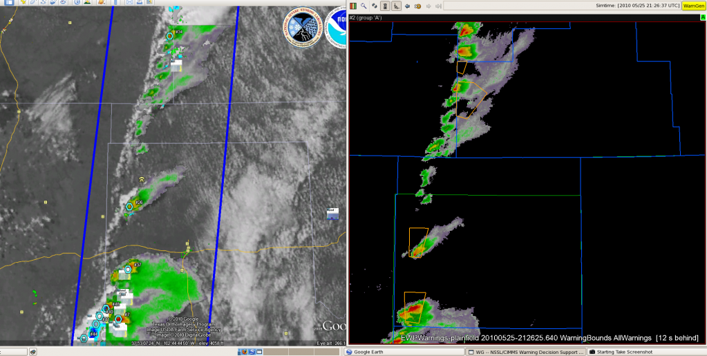
We worked the area of the central High Plains today, with forecasters alternating between the Amarillo, Dodge City, and Pueblo WFOs.  In fact, there were even severe storms in GLD area (the V2 storms) but we didn’t want to keep flipping to new WFOs, looking for more continuity.   We opted to go with a “full-day” IOP (versus 3 hour max), starting the shift by examining the pre-storm GOES-R CI products like in a real WFO environment.  It turns out that the visitors had no problem with the extended IOP, so this began a trend for the remainder of EWP2010 – nearly full-shift real-time IOPs.  At times some of the forecasters would be taken aside for half the shift for the LMA archive case but for the most part, the remainder of EWP2010 operational shifts would be devoted mainly to real-time operations.

GOES-R CI products were once again sparse owing to cirrus, but the overshooting tops product got more of a workout.  The isolated supercell in Baca County provided the best example of the product, giving more confidence to the forecasters in this radar-limited region.  However, the enhanced-V detection algorithm didn’t have much even though the visible satellite data was showing these signatures.  It was surmised that the coarseness of the 4 km IR data git these signatures, an issue that will be rectified by GOES-R’s increase spatial resolution.  More information is reported in GOES-R HWT blog posts here and here.

This was the first time that the forecasters were using he MRMS data in a real-time IOP.  Of particular note was the use of the Reflectivity at -20degC product, which is heavily used via the AWIPS Volume Browser at some WFOs (not using multi-radars, however).  One of our forecasters had a special color map for the product, which added white and then blue and then magenta solid colors at 55, 60, and 65 dBZ, to help identify the 60 dBZ threshold, which is a good rule of thumb for the new 1″ severe hail size criteria.  This was saved as the “CVKING” color map, after its originator, Jim Sieveking (LSX WFO).  It was also found that the MESH was spot on with its size estimates, and the azimuthal shear products were useful for the TOR decisions.

Greg Stumpf (EWP2010 Operations Coordinator)

Tags: None

Live Blog – 25 May 2010 (7:00pm)

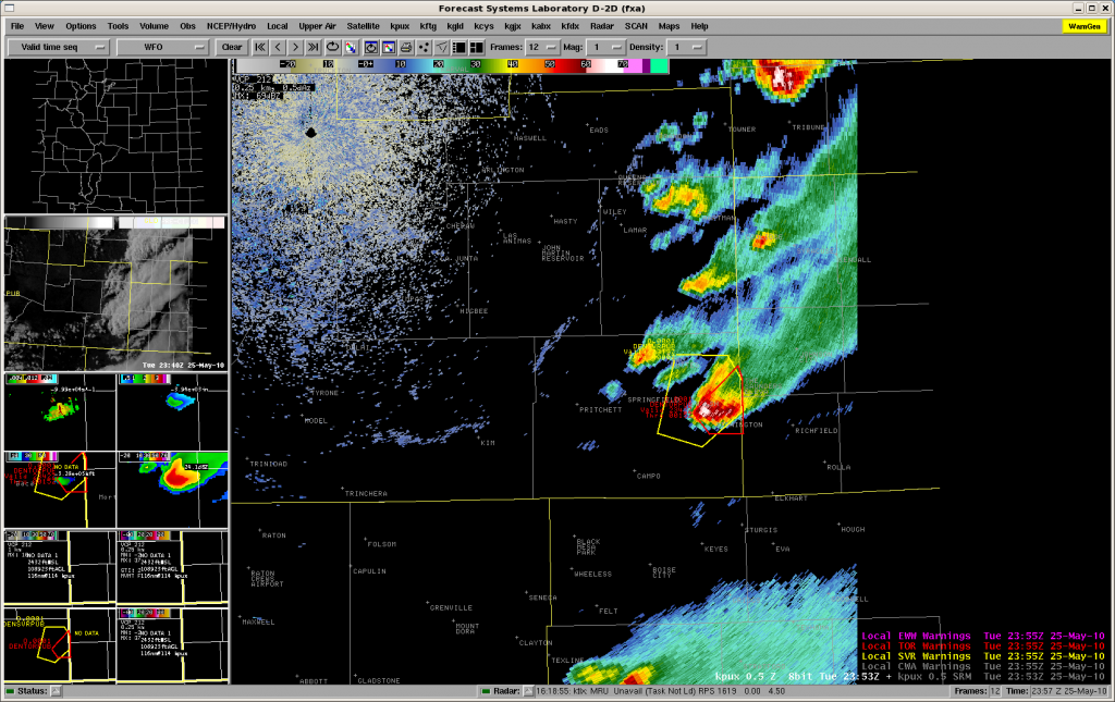
PUB team working a single supercell in Baca County, hvaing issued a SVR and then a TOR based on reports.  Rotation tracks show storm motion from about 230-240 degrees.  Image here:

Kristin Kuhlman (EWP Weekly Coordinator, 24-28 May 2010)

Tags: None

Live Blog – 25 May 2010 (6:30pm)

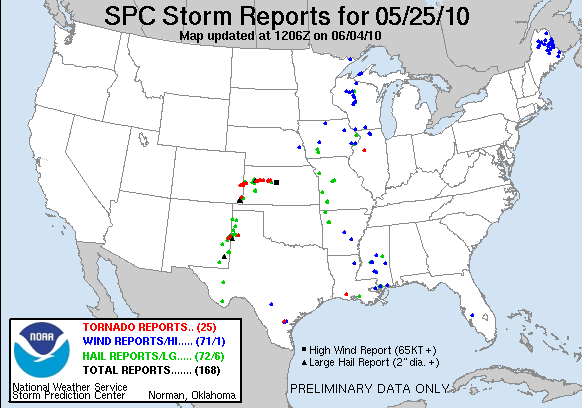
We now have teams working the PUB and AMA CWAs.  The AMA storms are now below severe limits, and they don’t have warnings out on the storms.  The PUB folks are working a few severe storms along the CO-KS state line, which have had numerous tornado reports (likely non-supercell tornadoes, at first).

Kristin Kuhlman (EWP Weekly Coordinator, 24-28 May 2010)

Tags: None

Live Blog – 25 May 2010 (5:30pm)

We finally have the slow load problem for the experimental data on AWIPS fixed, and ORPG issues fixed, so for the last 45 minutes or longer, all data have been loading on time and fast.  Crossing our fingers that our electronic duct tape will hold together.

One team is working storms for DDC’s area, but unfortunately, most of the storms have been hanging out just west of their CWA in PUBs area.  So after a couple of hours waiting for storms (one SVR was issued and the storm dies rapidly), we ae going to switch that team to PUB.

Meanwhile, the other team has been working AMA’s area, and has been quite active issuing SVRs, mainly for hail threat.  There is one significant left moving storm, and another “right mover”, actually nearly stationary, which are both hail threats.  No TORs issued yet.

Greg Stumpf (MRMS Principle Scientist)

Tags: None