LAPS Theta-e vs. NearCast Theta-e Difference

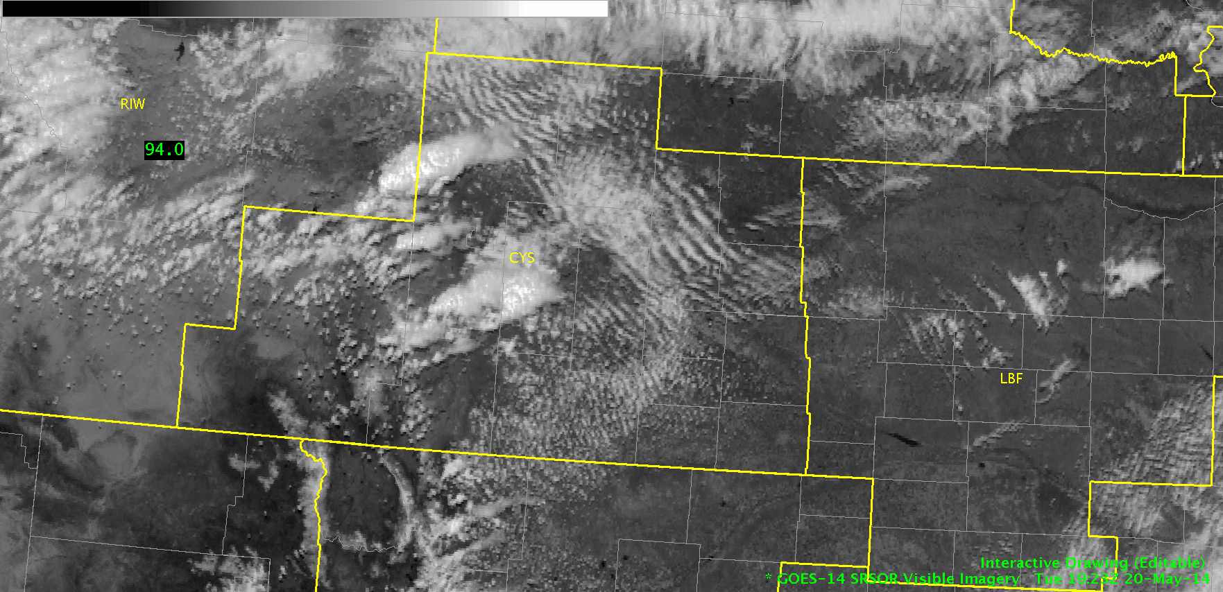
For today, my area of focus is in the DVN CWA. I began by looking at some of the satellite imagery and associated products, such as CI and OT detection. It’s still a bit too early for the OT product to be useful and the CI product is just now beginning to hone in on the developing CU field across the region. In the first image below, I’ve scalloped the region where the CU field has been evidently increasing in coverage and vertical growth. The CI product doesn’t show anything above the 40% range just yet but it still is a good way to bring attention to this area for possible initiation as conditions become increasingly favorable for development. There is a location just south of the area I’ve outlined that shows a 70% chance for CI so that’ll be something to watch as well.

2025Z_Vis_CI

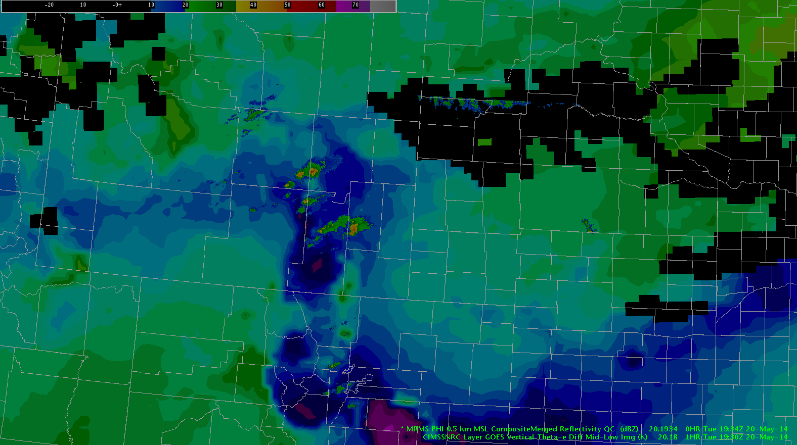
In the next image (below), I loaded the CONUS LAPS theta-e analysis (image) along with wind and METARs/station plots (the 800×800 domain is not available for this region today). Again, the area of interest is across the northern border of the DVN CWA. Except for the bulls eyes that appear where there are seemingly bad obs being ingested (when toggling over to the dewpoint analysis, these locations are evident), this has been a good situational awareness tool as well as a good product to put together a mesoscale analysis.

2015Z_LAPS_theta-e

Comparing the analysis above with the theta-e difference product below, much of the DVN CWA is under an area of convective instability. Unfortunately, the aforementioned scalloped area of interest in the northern half of the CWA is blacked out so I’ve had to infer and fill in where a lack of data exists. It would appear that a gradient exists right through this area, which lines up with all previously analyzed parameters and products hinting that this is the area to watch over the next 0-2 hours.

2030Z_Theta-e_Diff

~Linda

Tags: None

Short Term Afternoon Update CYS

Currently convection across the northern sections of the CWA is anticipated to slowly trend down as it chews through surface instability showing up in CAPE fields of the LAPS.  In addition Near Cast  models is showing best mid to low level instability  is moving north out of the CYS CWA and into the RIW CWA over the next few hours. This should further lend to a downward trend.  for convection across the area. Remaining storms of significance are anticipated to chew towards the east into Nebraska along a narrow and subtle boundary on visible satellite  and showing up in 19Z LAPs run on CAPE fields as an enhanced area.

Grant H.

Tags: None

A Very Basic Mesoscale Analysis

I was checking out the NSSL-WRF Simulated Satellite Imagery compared to the actual IR Satellite and it verified pretty well.  You can see low clouds over parts of Iowa and Nebraska and the idea of the vertically taller clouds is there..just not exactly in the same location.  At this point I like the idea of the model.Simulated Satellite Imagery Compared to IR Sat

So if I go with this model you can see below convection would initiate between 22-23Z over Central Iowa and S. Wisconsin bordering N. Illinois and then move East-Southeast.

Simulated Sat Imagery Convection

This actually would be supported since the environment looks unstable that it is moving into.  You can see on the Nearcast GOES Vertical Theta E Diff Mid Low that the high instability is from Central Iowa to N. Illinois and it looks like a boundary is there as well.

Nearcast Instability

So now we shall wait and see if this actually occurs. My watered down mesoscale discussion – Vollmar

Tags: None

MESH vs Past Hail Algorythms.

Screenshot-CAVE:CYS - D2D

For the storm observed in the earlier blog the MESH algorithm is kicking out between a half inch and an inch. The reports that came back almost immediately following this storm were very similar at around 7/8 inch.  In the past for a high plains environment hail algorithms would kick out hail of about double what occurred in reality. This newer algorithm seems to negate the old “factor of”  methodology or at least will force the forecaster to re-acclimate  to a new “factor of” or a new rule of thumb.

Grant H.

Tags: None

vLAPs versus reality. CYS

May20th 2023Z

It appears that on some runs of the LAPs that it can certainly nail the dominate storms to a very specific area. This is different from yesterday where cells were very displaced from reality. What is standing out here about these storms in particular is that a cold pool is spreading out in CAPE field on the background. This storm is reported as having half inch hail which is  very close to warning criteria. Knowing that the cold pool is spreading out helps to form a feeling that the support for this cell is disappearing and it will probably weaken very soon, which can help to decide not to warn and keep FAR down. I’d also like to not that the CIMSS Prob of Severe model was close but not quite exceeding 50% percent which is one extra indicator for this storm  before this moment. little battles one by one.

Tags: None

EWP Operations Update – Tuesday 5/20

Our forecasters this afternoon are only four feet from each other in the HWT, but they are operating four CWAs apart in Cheyenne, WY (CYS) and Quad Cities, IA/IL (DVN).

Our CYS team is leveraging Super-Rapid Scan, LAPS domain placement from yesterday, and the potential for lightning detection from the few active Northern Colorado LMA sites in their diagnosis of convective potential and current analysis of developing convection in Albany and Platte Counties.

Super-Rapid Scan Imagery over WY from 1923z-1941z.

Our DVN team is performing a mesoscale analysis of the region around IA/IL/WI where the highest potential for severe weather and its associated hazards are expected. As destabilization is forecast to occur in the next hour or so, hopefully we will see some cells in this area by 22z.

EFP Day 1 Probability of Severe Thunderstorms

-Darrel Kingfield
EWP Week 3 Coordinator

Tags: None

NearCast and the MRMS

MRMS_nearcast_20_1930

We have overlaid the MRMS combined reflectivity here and the theta-e difference for the storms developing in eastern WY. The storms appear to be developing in a region of the highest instability for the region indicating they could intensify as they continue to develop. It also indicates that the instability axis is fairly narrow.

-JB

Tags: None

NearCast Combined with Visible

visible_20_1915 near_cast_20_1730

Initial impressions today indicate that the NearCast model is providing additional confidence to what the visible satellite imagery is indicating. In the above visible imagery there appears to be a nice surfaced-based CU field from eastern NEb into northwest KS and then extending into southeast WY. On the NearCast model there is a ribbon of highest instability along this axis of CU as well.

-JB

Tags: None

EWP Status for Tuesday May 20th – 1:00pm to 9:00pm Shift

Another somewhat marginal day ahead for Tuesday with a two possible regions of potential convective initiation during the afternoon hours. SPC Provides two regions with a “SEE TEXT” designation.

SPC Day 2 Outlook issued at 1730z.

1) Northern Colorado/SE Wyoming – Upslope flow as the low pressure moves south through Nevada will provide a lifting component but lack of forecast surface moisture provides low confidence in sustained deep convection over the area. Regardless, high-based convective potential will be entertained in this region due to its collocation with the Northern Colorado LMA.

2) Northern Illinois/Southern Wisconsin – A cold front will progress across the upper Midwest through Tuesday, paired with surface moisture feeding into the region from the south. Forecast soundings show a weakening inversion from 21z to 00z where in NW Illinois, SW Wisconsin where the front is forecasted to propagate tomorrow afternoon. This coupled with high unidirectional shear aloft will provide the best change for long-lived convection with wind and hail being the primary threats.

GFS40 00Z forecast sounding in Ogle County, IL
GFS40 00Z forecast sounding in Ogle County, IL.
NAM40 00Z forecast sounding in Ogle County, IL
NAM40 00Z forecast sounding in Ogle County, IL.

EFP Day 2 probabilistic forecasts match this assessment with 5%-10% probabilities of wind/hail in the area.

EFP Day 2 Probability of Hail forecast.

We will meet in the HWT at 1pm to participate in the EFP forecast briefing before having the Monday product debrief in the Dev Lab.

-Darrel Kingfield
EWP Week 3 Coordinator

Tags: None

Daily Summary: Week 3, Day 1 (May 19th, 2014)

Today started with such promise (or blind optimism…whatever you want to call it): an isolated region of “SLGT” risk encompassing parts of of SE Wyoming and W Nebraska with many storm-scale models showing isolated thunderstorm initiation around 21z. EFP probabilistic forecasts were focused in this area as well.

Day 1 forecast probability of hail. A 20% bullseye was located in the CYS and LBF CWAs.

Forecasters were situated in the Cheyenne, WY (CYS) and North Platte, NE (LBF) for the duration of the shift on the edge of their seats waiting for initiation.

We must realize that not all days will be “end of the world” scenarios, and today provided a great medium for forecasters to be exposed to several of the experimental product sets for comparative analysis and evaluation (sans OUNWRF).

Forecaster/Investigator interaction during the early evening on May 19th.

vLAPS was utilized to (1) identify and diagnose regions of enhanced instability (mainly CAPE) and (2) validate forecast composite reflectivity with MR/MS composite reflectivity. Throughout the day, comparative analyses of the NSSL-WRF simulated satellite imagery with real-time IR/WV fields were analysed. Any convection was immediately pounced upon with Super-Rapid Scan visible analysis, ProbSevere and Convective Initiation product analyses. NearCast was utilized to gauge storm lifetime and identify regions of destabilization.

The tracking meteogram was put through its paces today with numerous data dropouts observed in the time trend graph during periods were these data were available. Forecasters consistently wanted to use the 0.5 deg reflectivity mosaic product for tracking.

Near the end of the shift, total lightning from the Northern Colorado LMA was observed in Laramie and Kimball Counties in Wyoming which gave forecasters (1) exposure to the SPoRT LMA plugin and (2) guidance on how total lightning information can be combined with other sensor information (e.g. radar, satellite) in the storm interrogation process.

Flash Initiation Density and MR/MS Merged Reflectivity combination at 0024z.

-Darrel Kingfield
EWP Week 3 Coordinator

Tags: None