

Typical pulse convection seen in Harris county in southeast TX. As these storms pulse and fall, the lightning jump algorithm has fairly consistently shown a corresponding jump around 6 sigma, down to 4, and then to zero as the storms collapse.

Month: May 2015
Storm Develops in Nearcast Model Vertical dThetaE Max
The good: The initial storms of the day in the Midland, TX forecast area formed in the Nearcast model most unstable differential thetaE depicted in the 0-1hr forecast (see the Nearcast+Radar+Visible image below).
The bad: Because my forecast area (San Angelo, TX) further east had prolonged morning clouds (see 14Z Visible image), the retrievals could not be accomplished and the instability trends in the Nearcast model through 9 hr were not available.
Rocky


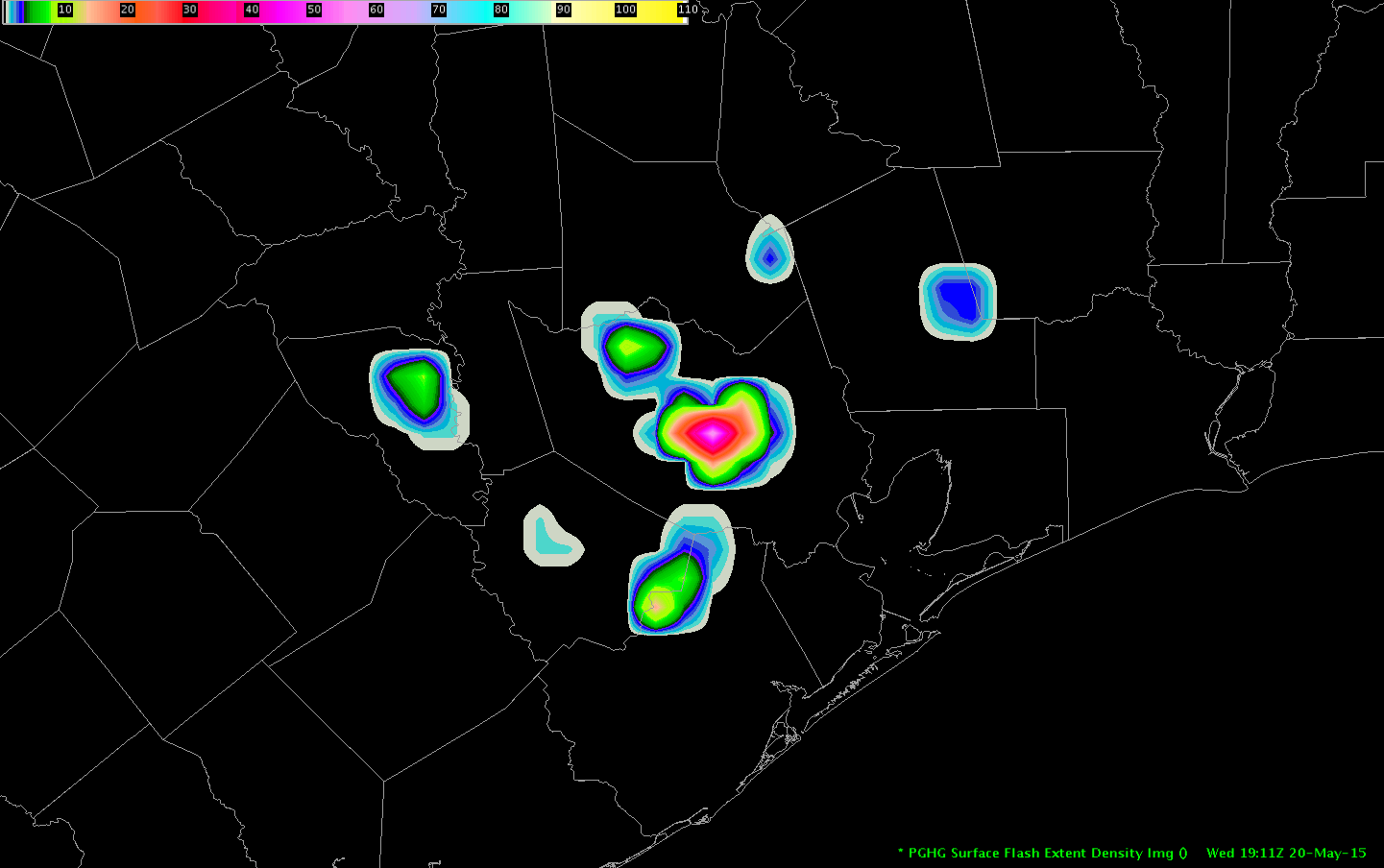
LAPS Gradients Focus for Convection in MAF CWA
LAPS PW and Stability all did a good job depicting the moist unstable air in the sou6thern and eastern portion of MAF CWA. The area enclosed in the white line represents initial convective initiation. As has been the case the past two days the north-south oriented line is along a zone of tight gradient of PW (and CAPE and other stability parameters).
In this case the PW field also shows more discreet areas of higher PW where convection is initiating in an east-west band in an area of clearing skies ahead of the surface cold front.
Overall, I think LAPS has done a very good job in providing an initial view of environmental conditions (and gradients) during initial severe weather analysis and spin-up. It helps focus in on areas most likely to see initial convective development, which can be verified against numerical guidance.
-snowstrm


MAF first storm timeline
Brewster Co TX cell was first of the shift in the MAF CWA. Creating this to compare to the evolution of other cells in this environment as the afternoon goes on.
1730Z – CI value at 73%, clearly the only object of immediate interest in the region at that time
1812Z – Prob Severe first passes 50% (jumped to 63%) with strong growth and moderate glaciation
1818Z – STA
1815-1822Z – first significant jump in ENI TFR (image below)
1822Z – Prob Severe reaches 90%
1838-1845Z – another significant jump in ENI TFR
1838Z – MRMS MESH first indicates sustained 1″ hail potential
1840Z – DTA
1842Z – MRMS MESH first indicates 2″ hail
1844Z – cell split becomes evident
-Holaday
Severe storm in north Houston
Prob severe spiked up to 73% for the warned storm (top photo). This also corresponded with a dramatic PGLM flash density increase to over 60 (bottom photo).
HGX First Warning of the Day
Using the PGLM, ProbSevere and KHGX all-tilts, warning decision was made for large hail and wind.
The PGHG flash densities spiked at 66/min at 1906z

Meanwhile, the ProbSevere also was increasing. After remaining steady at 20%, it jumped to 80 percent then maxed out around 90 percent.

On the other CAVE perspective, the KHGX radar data showed a weak hail spike at the 5.1 degree slice. The Z/CC showed this fairly well.
The combination of the ProbSevere, PGLM lightning densities and the radar data provided enough confidence to go with a warning.

George
Rapid Scan Comparison
The top image below is SRSOR Visible at 1820UTC. The second image is regular GOES Visible at 1745UTC. There was a lot of useful information available in the rapid scan in between regular GOES scans (in this case 45 minutes between images in AWIPS). The Rapid Scan showed clearing skies south of a cold front and west of a weak surface low. Briefly following clearing the rapid scan clearly showed growing cumulus/convective initiation along the lines with scalloped area below. Details of individual cloud elements (including tops quickly blowing off with initial convection) was very obvious in the rapid scan.
While regular GOES imagery reflected the general trends on a larger scale, it did not reflect the extent of clearing skies or convective growth. Evolution on the storm scale is not evident.
-snowstrm


PGLM Color Curves HGX
Developing weak convection over HGX area with low flash densities. Comparing two color curves, I prefer the ‘blue to green’ gradients for values less than 10. It was easier to discern the values, especially once values do exceed 10. The other color curve (green to yellow) was harder to distinguish as it went from green to yellow to red back to a yellow color. Granted, this storm is rather weak with low flash densities.


George
Spring Warning Project – Shift Status Message for Wed 5/20 (12-8 pm)
The Spring Warning Project shift for Wednesday 5/20 will be 12-8 pm. We will begin in the Development Lab.
Gabe Garfield
EWP Operations Coordinator
pGLM color tables in NTX
Example pGLM total lightning color tables in north Texas around 0045Z.
All are layered over radar mosaic. Aware though that this may not be the way many other users build the map.
Default
Not much resolution in values below <10, but this may or may not be a meaningful feature. The forecaster needs more information to form an opinion about that.
Drawn to the very distinct separation from the background by starting the table with white (unlike most other layers) and also to the logical flow through the colors.

LMA_1
Something of a compromise between above and below. Pops above background, and resolves very low values <10.

LMA_2
Outline not always cleanly separated from background
Ramping from yellow to orange and back to yellow does not seem intuitive to the forecaster at this time.

-Holaday