Update to make note of how valuable I believe it will be to have 1 min GOES imagery with CI overlayed. The GOES R era cannot come soon enough. With this as part of a total situational awareness of the environment (using v laps NSSL WRF etc), I cannot but think it will lead to improved nowcasts/warning lead times
Month: June 2014
Long-Track Supercell Predicted by OUN WRF
High Risk Day 4 2025Z 3 June Warning issued
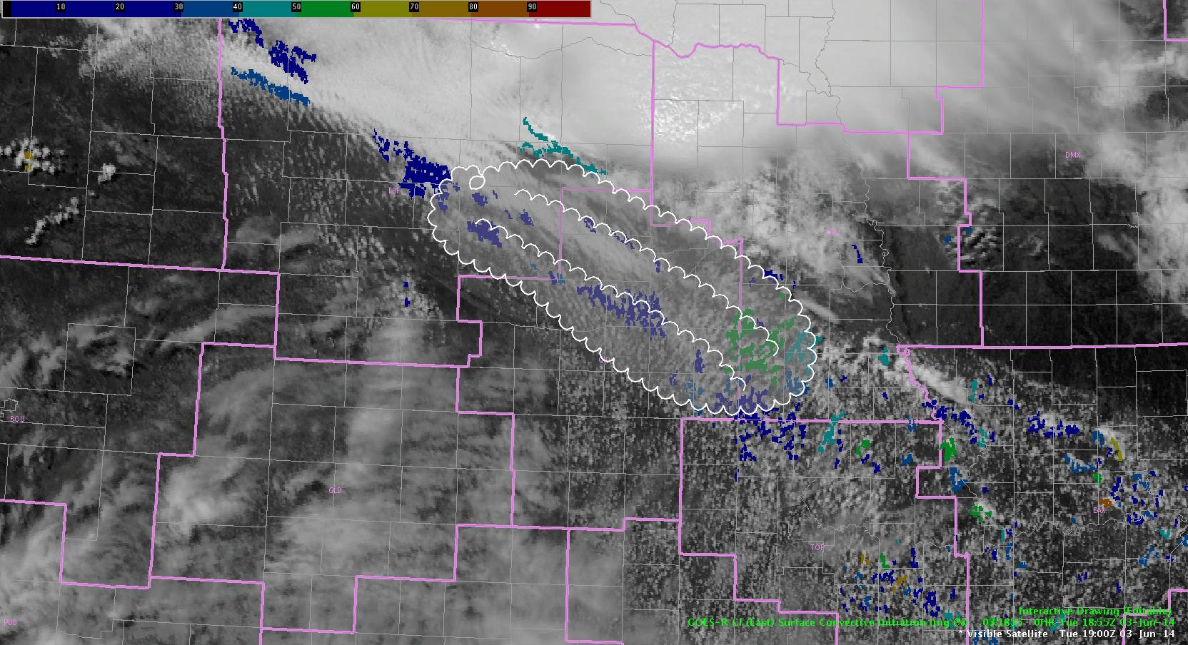
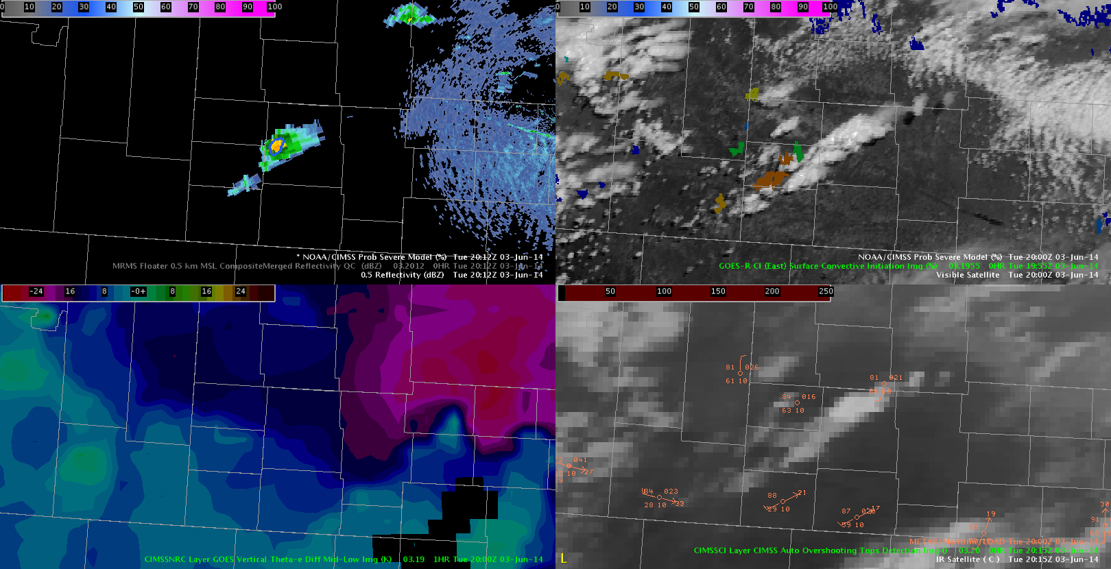
at 21013Z Prob SVR kicked in at 20% SFC CONVEC INIT at 84%. Partner issuing warning based on extreme environment ahead of cell and sit awareness, 
BULLETIN – IMMEDIATE BROADCAST REQUESTED
SEVERE THUNDERSTORM WARNING
NATIONAL WEATHER SERVICE NORTH PLATTE NE
215 PM MDT TUE JUN 3 2014
THE NATIONAL WEATHER SERVICE IN NORTH PLATTE HAS ISSUED A
* SEVERE THUNDERSTORM WARNING FOR…
NORTHWESTERN GARDEN COUNTY IN THE PANHANDLE OF NEBRASKA…
* UNTIL 315 PM MDT
* AT 215 PM MDT…DOPPLER RADAR INDICATED A SEVERE THUNDERSTORM
CAPABLE OF PRODUCING QUARTER SIZE HAIL AND DAMAGING WINDS IN EXCESS
OF 60 MPH. THIS STORM WAS LOCATED NEAR BRIDGEPORT STATE RECREATION
AREA…OR 27 MILES SOUTHEAST OF SCOTTSBLUFF…AND MOVING EAST AT 35
MPH.
* LOCATIONS IMPACTED INCLUDE…
SUGAR LOAF HILL…LISCO…RICHARDSON LAKE…MUMPER AND CRESCENT
LAKE NWR.
PRECAUTIONARY/PREPAREDNESS ACTIONS…
SEVERE THUNDERSTORMS PRODUCE DAMAGING WINDS…DESTRUCTIVE HAIL…
DEADLY LIGHTNING AND VERY HEAVY RAIN. FOR YOUR PROTECTION…MOVE TO
AN INTERIOR ROOM ON THE LOWEST FLOOR OF YOUR HOME OR BUSINESS. HEAVY
RAINS FLOOD ROADS QUICKLY SO DO NOT DRIVE INTO AREAS WHERE WATER
COVERS THE ROAD.
&&
LAT…LON 4184 10242 4183 10236 4144 10237 4148 10264
4174 10264 4175 10267 4181 10267
TIME…MOT…LOC 2015Z 270DEG 30KT 4167 10320
$$
DSatterfield
High Risk day 3 June part 3
above image is 2006. Seeing noticeable convec initiation on cells developing near Scotts bluff NB/WY border. Theta e diff shows extreme instability and local soundings showing potential for large tornadoes with SPC indicating High risk. No OT top detection as of yet but am monitoring this closely and hope to use this area to evaluate it and other HWT exper. products on a high risk day. Notable prob severe is not indicating anything and we have 40 dbz echo… we think this may be due to lack of KCYS nexrad data,
d satterfield
WBOC Salisbury, MD
GOES-R CI showing increasing potential for CI
EWP – Tuesday – Moderate Risk
Initial look was at the VLAPS. It showed convective development over the NE panhandle. Initially there was little in the way of deep cumulus there – and we suspected that CI may have been the result of garbage feeding in from the lateral boundary conditions. However, around 1930z VIS imagery indicated building CU – with echoes developing. So – the VLAPS was definitely onto something! Next step was to compare the 17z and 18z runs. And there was some consistency! The images below show the comparison. This would give forecasters confidence that vigorous CI is likely!
17z VLAPS (2000z and 2030z):
east vs west at 20z
based on the above image, its still up in the air as to which area highlighted will develop convection first, and just as importantly, which area will so severe first. The instability gradient to the west is more impressive, but the CI is higher and more consistent to the east. Stay tuned for updates…
jca
OUNWRF vs reality
High Risk Day, Tuesday 3, June part 2
Update at 1942z 3 june
Image below shows the convec initiation has risen to 92% in just around 15 mins. Noticing a STP of 12 in our area. with storms popping to the west…..
Multiple boundaries for possible convective development.
There are two distinct boundaries showing up in the visible satellite, as highlighted in the bubble. The GOES-R CI tool indicates 40-60% probabilities for convection along the line. Boundary interaction help with convective initiation as the boundaries move northeast. Will continue to monitor these lines.
-KP


d satterfield