Negating false positive/problems from larger LJDA scales.

May22nd 0009Z

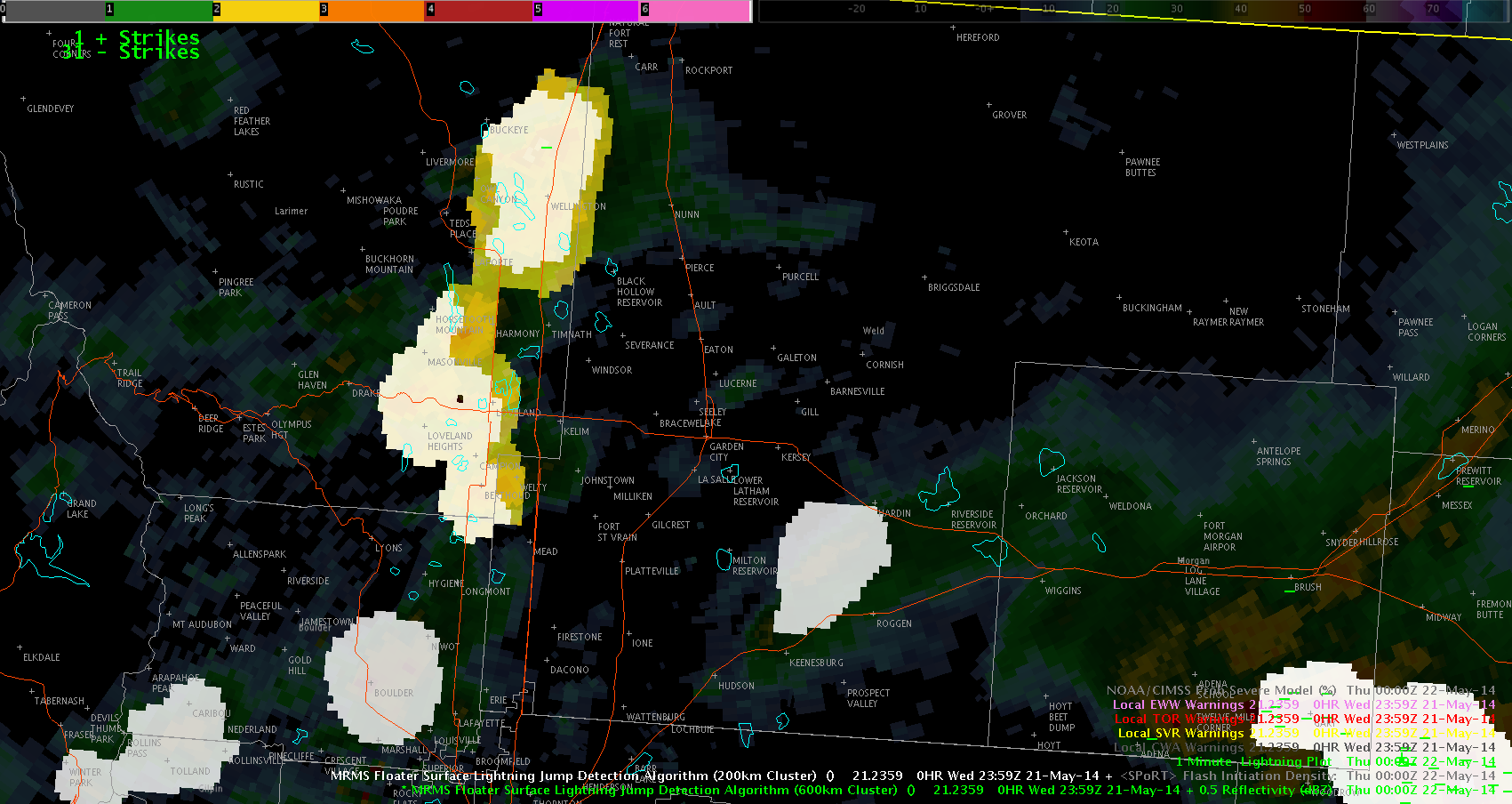
With the image above I just wanted to show that sometime the LJDA can combine storms and trigger a larger sigma warning than seems realistic. Especially when the storms seem to barely touch on radar. In this case it was a 2-3 Sigma jump in Yellow which would prep the forecaster to think about warning.

This false positive can be fixed by overlaying a smaller scale LJDA over a larger one to potentially split the storms and break the sigma back down to a more realistic approximation that would not trigger a reason for warning (after suspecting it to be a false positive).

Grant H.


Tags: None

Over-Shooting Top and Heavy Rain

ost_heavy_rain

Been watching the convection over northeast CO, and although the general trend of the severity of the convection is downward, the over-shooting top algorithm continues to ping over this area. This highlights that although the storms may not be producing severe weather, i.e. hail and/or wind, they could be significant rain producers and should continue to be monitored.

-JB

Tags: None

Total Lightning to forecast strengthening storm

lightning data


I have been watching the Total Lightning product over the developing storm and it shows both flash initiation density and flash extent density that have been increasing over the last 30 minutes.  That coupled with the increase on the Prob Severe, would lead me to believe this is nearing severe limits and I would then issue a warning.  I really like these products because it shows where the updraft is developing and also where hail would be found. ~ Vollmar

Prob Severe and Demise of Storms

prob_severe_2343

Watching trends in the probability of severe over northeast CO indicates a significant downward trend in prob severe with the low-lived storm that went through DEN. This occurred as the local office allowed the warning expire and the reflectivity signatures were decreasing as well. Provided confidence in letting the warnings expire.

-JB

Tags: None

A CI Update

Remember that screen capture of the 90% probability of convective initiation over Lawrence County, IN at 2130Z? By 2248Z, a decent cell had popped up in the NE corner of the county. Not sure if this necessarily verifies the product or not (after talking with the product’s contact here), but it does instill some confidence on using this product in the future.

2248Z_KIND_ref~Linda

Tags: None

Many False Detections on CI at Night

nighttime_ci

As of around 23Z we have switched over to CI for overnight detection. The false detections appear to increase once this switch happens. There still appeared to be some utility though as it highlighted area over southeast WY that developed, but one would need to use it with caution overnight.

-JB

Tags: None

Simulated Satellite Demise of Storms

simulated_ir_demise

The long-lived supercell that moved from the DEN area into northeast CO appear to be weakening as of 2330Z and the forecast simulated satellite data did well in forecasting not only the initiation of the convection, but also in the early demise in northeast CO.

-JB

Tags: None

Overshoot Top to Indicate Strong Storm

Overshooting top to predict severeI was using the Overshooting Top application and it showed one over the one storm for a couple of updates.  This led me to believe it had a strong updraft and then I looked at Prob Severe and it also trended up so I was going to issue a severe t’storm warning.  Now I want to see if this verifies.  ~ Vollmar


Tags: None

Simulated Satelite imagry from earlier.


WRF Simulated Satellite imagery from around initiation time. Initiation time for the simulation was running about 30 to 60 minutes delayed from reality. Not Good but Not bad if the WRF data arrived more than 1 hours early. I also want to point out that it did capture the main storm of the day and roughly the correct placement for initiation.

May21st 2258Z-1

First hints of initiation in Reality 1915Z.


May21st 2258Z-2

First hints of initiation in WRF Simulation 20-21Z time frame.

Grant H.

Tags: None

LAPS vs. MRMS Reflectivity

Attempting to give a mesoscale environment update for my warning partner, I pulled up all of the LAPS products available in the 800×800 domain. The 20Z run is the latest available data and the ongoing storms (as of 2230Z) are depicted to be in a decent region of surface CAPE (>2000 J/kg), practically no CIN, and high pockets of surface and 2-5km instantaneous updraft helicity on the front edge of the broken line of convection. When I analyzed the LAPS’ max base reflectivity product and compared it with real-time MRMS composite reflectivity, it does okay in the 2.5-hour forecast in depicting a general region of convection stretching from east-central Illinois ESE toward the IN/OH/KY borders. The model is spatially displaced slightly but at least captures the general overview of the current setup.

2230Z_LAPS_maxref2230Z_MRMS_compref

Moving forward to the 4-hour forecast (00Z), LAPS forecasts the following:

00Z_LAPS_maxref

If LAPS data is to be used to enhance near-term mesoscale forecasting, I personally would like to see some additional fields, such as wind, etc.

~Linda

Tags: None