HSDA Update

A quick look at how the HSDA performed around the time 4-4.5″ hail was being reported west of DFW…

Dual-pol base data showed very low ZDR / CC near the surface within the high Z core. Some elevated KDP in spots.

Note the large region of Giant Hail classifications. While the HSDA has been overdoing the region of GH class, this storm did have a sizeable swath of very large / giant hail.

4PANEL_05

4panel_hsda_05

Picca

Tags: None

EWP Status for 16 May 2013: 1-9 pm Shift

EWP Status for 16 May 2013: 1-9 pm Shift

Well, it looks like the most exciting weather day of operations this week is almost behind us.  Tomorrow appears to be another marginal / conditionally severe day.  Operations will likely shift north to Nebraska as a short wave moves across the region. This upper level support combined with low-level warm air and moisture advection provides the highest probability severe weather across the CONUS.  Ongoing convection in the overnight and morning hours may complicate timing and location of afternoon storms.  For convection that does occur, large hail and wind will be the primary concerns.

Again, timing is a bit difficult to predict due to the likelihood of overnight/moving convection, but considering it is likely to be a marginal day, I see no reason to switch away from our default schedule of 1-9 pm.

Likely CWAs:  North Platte, Hastings, Goodland

-K. Calhoun, Week 2 Coordinator

Tags: None

Flash Density Trace for Tornadic Storm Near Leon, OK

A tornado was reported at 0022Z near the town of Leon in OK. The associated flash extent density trace from the parent storm is below. Focus on the time frame between 00Z and 0031Z. Notice a consistent trend upward in flash extent rate…with a peak value of 48 at 0021Z. Unfortunately…the trace was not created soon enough to capture the flash rate as the storm was intensifying prior to 00Z but the upward trend in flash rate correlated well with the pre-tornadic organization phase.

tornadic_trace

Here is a look at the storm near Leon at the time of the tornado report. Rotation tracks peaked at 11 s-1, MESH was maximized at 0.47″ and the vertically integrated ice peaked at 16 kg/m-2.

storm_at_tornadotrack

Tags: None

Tornadic Debris Signature

Earlier this evening, the dual-pol base data did indeed indicate a TDS, as seen in low CC/ZDR co-located with apparent debris ball. The location matched the SRM couplet very well. However, it was not enough to set off the TDS algorithm.4PANEL_TDS

Picca

Tags: None

Numerous couplets in supercells just west of Fort Worth/Dallas

couplet_0036ZUpper left: reflectivity, upper right: velocity data, lower left: CC

Right and left moving supercells just west of Fort Worth/Dallas repeatedly produced significant rotation signals. In fact at 0030Z, the southern one had its rotation along its northern fringe although this signals was a very transient one (it survived for roughly 15 min). During that time, the northern supercell produced a pronounced hook echo and what looked like a debris ball in the lowest reflectivity scans (no signal in the tornadic debris signature). Helge

Tags: None

OUNWRF Hinted at Possible Tornado Development in TX with 1-3 Hr Lead Time

OUNWRFSurfaceMaxHrUpdraftHelicty01UTC051613The 22 UTC run of the OUNWRF hinted at surface max hourly updraft helicity maxima over central/north Texas 2330-02 UTC where a few tornadoes were occurring, but generally seemed to be a bit too far south and west with the maxima.  The 20 UTC depicted fewer surface max hourly updraft helicity maxima with similar displacements too far west and south. Michael Scotten

Tags: None

HWT: May 15th. Lightning Mapping/Warnings for OUN

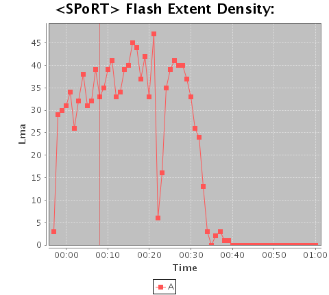
Loaded the one minute SPoRT Flash Extent Density product and used the editable Moving Trace tool. The moving trace circle had to be expanded for each frame; forecasters won’t like this because it doesn’t have a “apply to all” feature for this. It is also not intuitively obvious to forecasters that have been using other tools such as the warngen pathcast tool and distance/speed tool in AWIPS. The trace tool makes a graph showing “Flash Extent Density”, which showed trends in lightning for the selected storm.

Moving_Trace1914 UTC Flash Extent Density. This product could be useful for NWS event support to describe specific lightning threats to outdoor activities. It could also be useful to identify strengthening updrafts that could produce large hail. One storm that showed a quick spike in Flash Extent Density above 50 Lma at 1912 UTC went on to drop 1 inch hail at 1926 UTC, for a 14 minute lead time. See Becca’s blog entry on this storm.

There were several bad one-minute data samples caused by loss of input data into the Oklahoma LMA. Two of them are illustrated below.

1921UTC1922One minute Flash Extent Density showing the sharp drop that was apparently the result of a temporary loss of input data into the Oklahoma LMA. This occurred again at 1948 UTC see the trace graph below.

LightningTrace
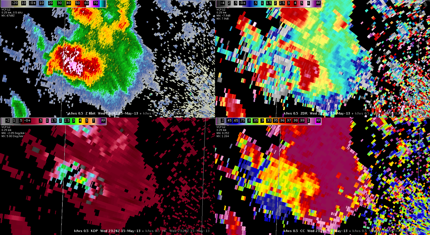
Warning operations began with a series of small mesocyclones, the first of which had a small hook echo. Tornado warnings were issued for three storms. A 0.5 slice of the OUN R/SRM was primarily used for storm interrogation and the 30 minute Oklahoma Surface and Mid-Level Rotation Tracks were used to see the right-turning trend for meso paths.

hook

meso

Top image showing OUN reflectivity of the first tornado-warned storm. Bottom image is OUN SRM showing another tornado-warned storm’s meso circulation.

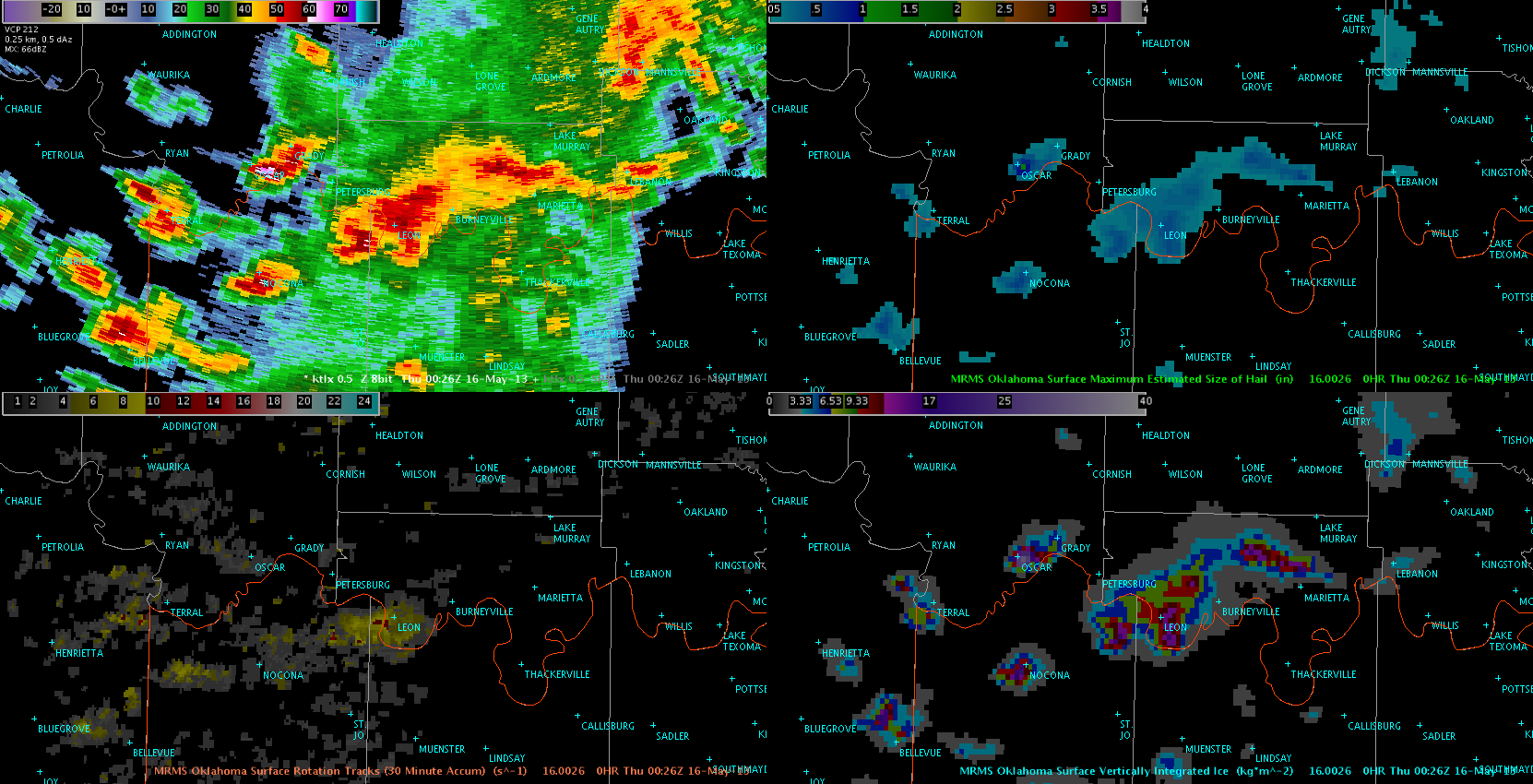
The trends shown on the rotational track products helped in narrowing the tornado warning polygons and thus minimizing the false alarm area for the tornado warnings. The surface rotation track was also used for evaluating whether a tornado warning would be needed for southern Jefferson County as a tornadic supercell moved parallel to the Red River. It also was a great way to show the cyclic nature of this meso.

rotationtrackMRMS Sfc Rotation track showing the redevelopment of the mesocyclone further east. The loop of this product helped save a false alarm tornado warning for Jefferson County.  The rotations along the line of storms were also shown, but the entire line was plotted in sequence, which avoids a noisier picture of the track. See image below.

rotationaltracksline

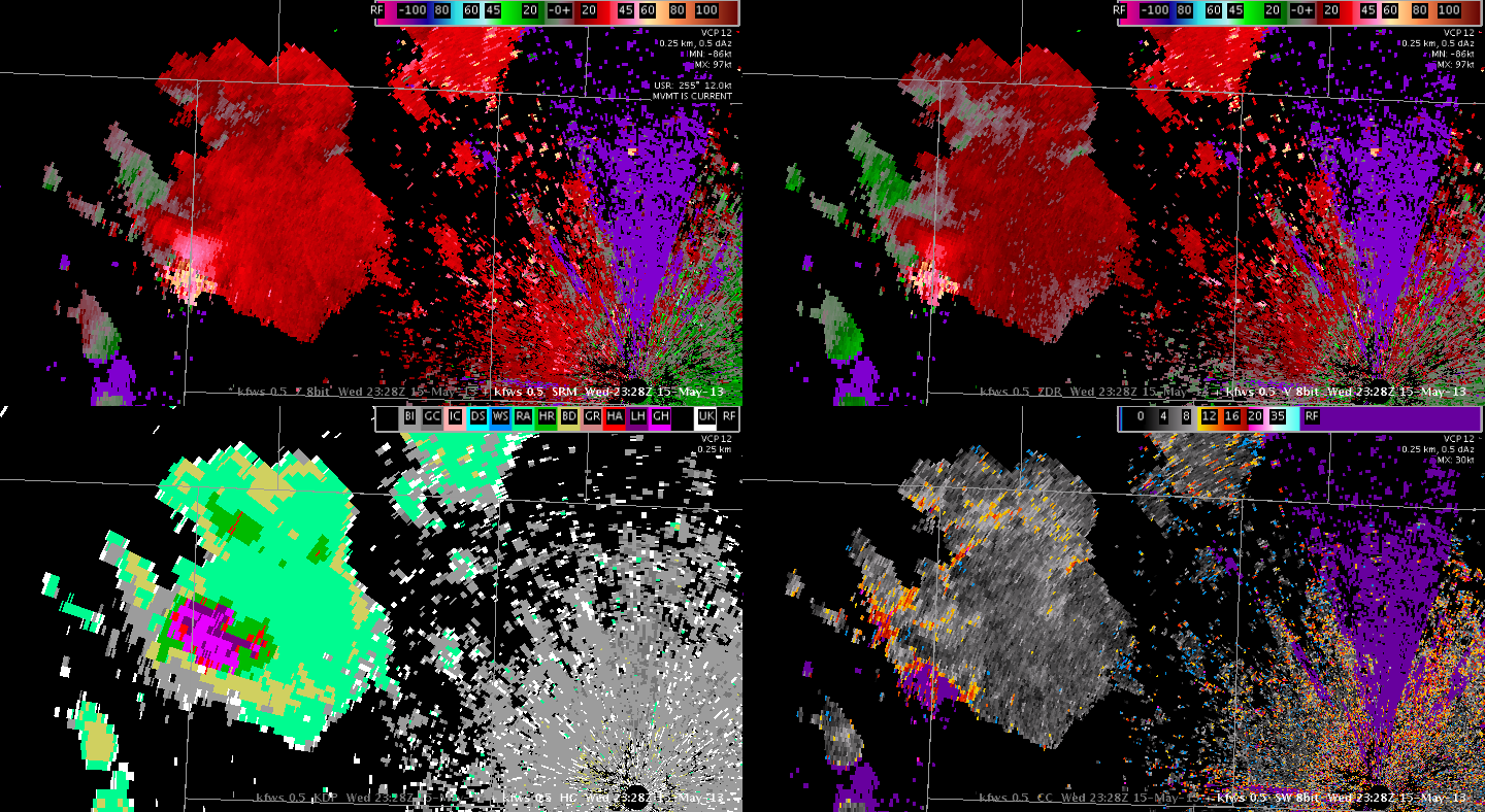
Another interesting thing noted with the rotational track algorithm was the inclusion of a rotation signature with range folded/improperly dealiased velocity data.

ROTATIONTRACKRANGEFOLDEDRANGEFOLDEDThese images are from around 0050 UTC 16 May, showing an area of range folding and bad velocity data that was plotted as an area of rotation by the SRT.

– Ostuno

Tags: None

Rotation Tracks and Lightning Associated With Weak Bow Echo

Rapidly developing convection showed a rapid increase in flash extent rates in the low teens to the mid 30s with a few pixels spiking in the 40s. This activity rapidly morphed into a bow echo that raced across south central Oklahoma. The SRM velocity gradient along the front end of the bow was very tight…and the rotation tracks product showed an interesting progression of bow-like rotation signatures from north to south. There were gaps between each line (seen in the graphic below) unlike a single storm track which is fairly continuous.

At the north end of the bow…the values of the rotation tracks were strongest which is to be expected in the region of the northern bookend vortex. The flash extent rate was relatively weak with the bow…along with weak sfc velocities estimated to be around 20 kts from mesonet observations. So although the reflectivity structure looked as if it could be an intense bow echo with moderate midlevel convergence…and rotation tracks were depicting embedded circulations within the line…no reports of severe wind or damage were reported or observed.

Bowbow2The highest values for sfc rotation tracks around 23s-1 were in the vicinity of the bow where smaller cells were merging with the main line near the northern bookend vortex. The best velocity couplet depicted on SRM went between Byng and Francis around 2349Z and was just southeast of the highest values for the sfc rotation tracks.


Tags: None

LAPS_OUN 22UTC Updraft Helicity Gives 1-3 Hr Lead Time to N TX Tornadoes

LAPS_OUN1kmUpdraftHelicity0015UTC051613 kfws0.5Ref0015UTC051613The LAPS_OUN_1km surface instantaneous updraft helicity from the 22 UTC run captured the tornadic supercell near 00 UTC between Mineral Wells and Fort Worth, Texas.  The 0015 UTC instantaneous updraft helicity from the 22 UTC run is depicted above.  The kfws 0.5 reflectivity at 0015 UTC is depicted below.  The instantaneous updraft helicity is maxed out very close to the location of the supercell. The 21 UTC LAPS_OUN run indicated some potential for tornadic supercells across northwest Texas 23-24 UTC, which was about 50 to 100 miles too far northwest than what actually occurred. Michael Scotten

Tags: None