
On Tuesday, our day began at 1 p.m. in the Development Lab. We spent 20 minutes debriefing on Monday’s operations, after which we examined the Day 1 forecast. At the conclusion of the EWP forecast discussion, we joined the EFP in the HWT to discuss their forecast. Upon further review, we concluded that the Goodland and Dodge City, Kansas County Warning Areas would provide the best opportunities for initial storm development.
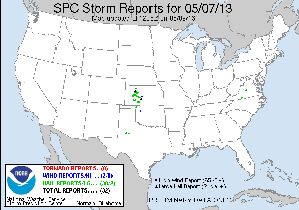
We waited for convection to form until 4 p.m., when robust development began in Kansas. The Goodland crew – consisting of Jonathan Kurtz and Jonathan Guseman – issued 12 severe thunderstorm warnings over the course of the evening. The Dodge City crew – consisting of Andrew Hatzos and Nick Hampshire – issued 10 severe thunderstorm warnings. The mesoscale desk – consisting of Hayden Frank and Marc Austin – monitored the mesoscale through late afternoon. At that time, it became apparent that storms were likely to develop in the West Texas Lightning Network, so Hayden Frank monitored the Lubbock storms. Geoff Stano (NASA/SPORT) noted that the storms produced less robust PGLM signatures than expected (compared to the Southeast networks). These assignments were carried through until 8:15, when the forecasters filled out daily surveys to end the day.
-G. Garfield, Week 1 Coordinator