SJT Crockett Co Update @ 23Z

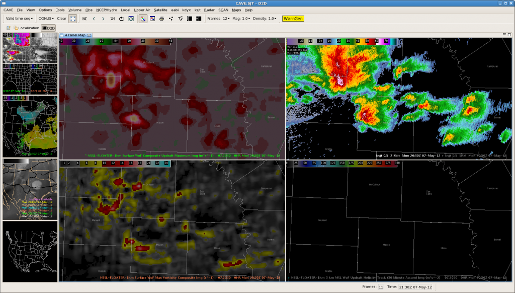
NWS SJT was monitoring two areas of thunderstorms.  the strongest storms were located immediately west of Crockett Co., moving north and being influenced the westbound outflow boundary from earlier convection.  Max Composite Updrafts were showing 15-17 m/s though inconsistently.  These storms are capable of producing 1-1 1/2 inch hail according to the MESH algorithm.  Though the strongest updrafts and threat of severe hail were located west of Crockett county, we will continue to monitor this complex for the potential warnings in the near future.

The second area of storms were in central Crockett county and does not appear to be a threat.  Brief heavy rain will be the primary impact.

Nunez

Tags: None

EWX Meso Update 2230ZUTC

day 1 warning

Issued a warning on a cell for hail and wind based on radar trends and the fact that this storm was moving into a good environment.  The above image of radar reflectivity shows the storm moving southeast into a good theta-e environment depicted by the yellow axis on the above image.  The theta-e imagery is CIMSS-NRE Layer GOES Vertical Theta-e Diff Low-Mid Img

RB/AMS

Tags: None

SJT Crockett Co. update

OUNWRF depicted area in ne Crockett county where theta e was increasing and weak circulation was present.  We’re tracking a storm over the sw part of Crockett county moving in this same direction and could lead to strengthening.  Hovis/Nunez

Tags: None

SJT thoughts @ 2200Z

Thunderstorm anvil was masking the new development upstream so the CI/CTC products were not registering data.  The Max Updraft Composite definitely proved to be useful with the new development over Mason Co. and anticipated the collapsing updrafts over San Saba Co. where 1″ hail was detected with 10 minutes lead time.  Nunez

Tags: None

SJT Meso Update @ 2130z

Thunderstorm over northwest Mason county ?is showing Updraft Velocities  of 23 meters/sec and maximum vorticity values approaching 17 s-2.  Radar shows outflow boundary is moving southeast and should impact the storm by 2140z.  Expect storm will continue to increase in intensity.   Hovis/Nunez

Tags: None

SJT: EM Discussion @21Z

Location: Latest guidance supports continued development of strong to severe thunderstorms moving across McColloch, San Saba, Llano, San Saba and Mason counties.

Impacts:  primary impact will be large hail and damaging winds.  there is still potential for isolated tornadoes.

Met discussion:  OUNWRF showed evidence of moisture convergence on the h8/h7 wind and theta E H8-7 layer; MRMS Max hail size estimated 1.5″ hail;  UAH CI strength of signal showed 80-100 values over the areas of favorable moisture convergence; CI-CTC projected new development over Llano county.

WFO SJT

Tags: None

Outlook – 7 May 2012

The 2012 edition of the Experimental Warning Program’s spring experiment, or EWP2012, kicked off today.  We want to welcome our first set of visiting forecasters:  Ryan Barnes (WFO, Norman, OK), Jeffrey Hovis (WFO, Charleston, WV), Roland Nuñez (CWSU, Houston, TX), and Andrea Schoettmer (WFO, Louisville, KY).

Today, the forecasters are becoming familiar with how to access the various experimental products and loading and building new procedures.  Currently, an MCS is underway in SC Texas, and we have localized to both San Angelo, TX (KSJT) and Austin/San Antonio, TX (KEWX).  The SPC DAY1 outlook shows the approximate area of concern (probability of severe hail shown below).

Greg Stumpf, EWP2012 Week 1 Weekly Coordinator

Tags: None

EWP2012 Welcome!

We are in the process of getting the final preparations ready for the EWP2012 spring experiment.  Like in 2011, there will be three primary projects geared toward WFO applications, 1) evaluation of 3DVAR multi-radar real-time data assimilation fields being developed for the Warn-On-Forecast initiative, 2)  evaluation of model performance and forecast utility of the OUN WRF when operations are expected in the Southern Plains, and 3)  evaluation of multiple CONUS GOES-R convective applications, including pseudo-geostationary lightning mapper products when operations are expected within the Lightning Mapping Array domains (OK-TX, AL, DC, FL).  We will be conducting EWP2012 for five weeks total (Monday – Friday), from 7 May through 15 June (Memorial Day week excluded).

New for this year, we will be conducting our operations using the AWIPS2 platform.  For most of our visiting forecasters, this will be the first time they will use AWIPS2 for real-time operations, and we hope to get some feedback on its utility.  Also new for this year, we are going to attempt a “flexible” shift schedule on Tue, Wed, Thu.  A the end of the prior day’s shift, we take a look at the Day 2 outlook and forecast models and make a best guess at determining the timing and location of the follow day events.  Our flex shifts will begin anytime between 12-3pm and end 8 hours later.  This will allow us a better opportunity to catch severe weather events that had peaks outside our normal operating hours in the past.

We’ve “reclaimed” our Mondays as a real-time operations day.  In the past, this day was mostly spent providing training and orientation to the visiting forecasters, and if there were any real-time events, we might not have the opportunity to work them.  New for this year, the forecasters are taking the training at their WFOs/CWSUs before they arrive in Norman, via a series of self-paced presentations, Articulates, and a WES Virtual Machine case with most of the experimental products included.

Finally, each Friday of the experiment (11 May, 18 May, 25 May, 8 June, 15 June), from 12-1pm CDT, the WDTB will be hosting a weekly Webinar called “Tales From the Testbed”.  These will be forecaster-led, and each forecaster will summarize their biggest takeaway from their week of participation in EWP2012.  The audience is for anyone with an interest in what we are doing to improve NWS severe weather warnings.

So stay tuned on the blog for more information, daily outlooks and summaries, live blogging, and end-of-week summaries as we get underway on Monday 7 May!

Greg Stumpf, EWP2012 Operations Coordinator

Tags: None