JAX Meso Update 1940Z

Nearcast data shows favorable conditions for convective initiation and maintenance through mid afternoon.  The first 2 images of nearcast at 19Z and 20Z show good theta-e values (yellows) at 780 mb (upper left) with a slightly cooler drier environment aloft (greens) at 500 mb (lower left).  Bright greens over central and eastern portions of JAX area support a favorable convective environment.   This analysis combined with soundings and other environment data are supportive of small hail with storms early this afternoon.

19Z:

20Z:

In the later 2 images below at 21Z and 22Z, the environment becomes less favorable for convection as we can see less of a threat of convection as the brighter yellows at 780 mb (upper left) begin to move off shore (a cold front enters the area).  Also at 500 mb (lower left), brighter yellows are observed moving into JAX central and eastern portions of the area indicating more warm/moist mid levels which would be less supportive of small hail and more supportive of heavy rainers given the environment conditions.  The theta-e difference (lower right) depicts most unstable/moist environment (bright greens) moving off shore as well.

21Z:

22Z:

AMS/Hovis

Tags: None

JAX-CTC Success @ 1832z

Around 1832z…cloud top cooling product showed strong cloud top cooling for two successive scans in the area of some showers moving across Berrien County in Southeast Georgia.  The showers  rapidly intensified with JAX composite reflectivity showing 55-60 dBZ by 1849z and 60-65 dBZ storm by 1904z.  Hovis/AMS

Tags: None

CHS Meso Desk @ 1905Z

HRRR output painted the merging of the ongoing line of non-severe storms and new initiation ahead of this line.  CI and CTC showed an evidence of early convective initiation though lead time near 30 minutes.  nunez

Tags: None

9 May 2012: Outlook

Today is a day we’re going to struggle for severe weather.  We have a risk along a cold front along the southeast coast, but instability and shear are marginal.  Convection in a line is ongoing in South Carolina at the time of our briefing, and the front is expected to move offshore from SC by about 6pm.  Further SW, the front trails to the FL Panhandle.  There is a marginal chance of severe all along the front.  So, we have started the day with one team working the Charleston, SC (CHS) WFO, and the other team working Jacksonville, FL (JAX).  The CHS team is diving into a situation where storms are ongoing (and CAE issued a SVR at the start of ops).  The JAX team will be primarily focusing on CI and nowcast issues if and until storms develop in SE Georgia.

For the evening, we may have one team operate a “CWSU” operation over the northeast Gulf of Mexico, making nowcasts for aircraft routing.  We’ll set them up as a WFO (either TLH or TBW), but “products” will be issued via the blog.  The other team may still work a land mass and issuing warnings.  There is also the outside chance we move back to south Texas if severe storms threaten there (in a “SEE TEXT”).  That decision will be made around 5pm.

Here is the SPC Day 1 outlook map:

Greg Stumpf, EWP2012 Week#1 Coordinator

Tags: None

Daily Summary – 8 May 2012

We operated in 5 different WFOs today, although out “bread and butter” was the Brownsville, TX (BRO) area, where several large supercells tracked across their CWA.  However, since they were mostly over open terrain, there were very few reports.  This is where we kept our MRMS domain most of the day.  Simultaneously, we had another team working the El Paso, TX (EPZ) WFO, concentrating on storms mainly in southern New Mexico.  These storms were mostly non-severe, except for one golfball hail report.

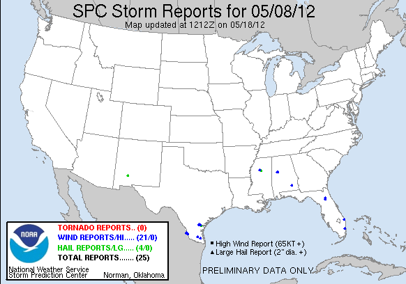
After dinner, we salavaged some storms in Midland, TX (MAF), and in Florida, hoping for the some PGLM action.  Both areas received no severe reports.  Here’s is the pretty meager storm report map:

120508_rpts Reports Graphic

Greg Stumpf, EWP2012 Week#1 Coordinator

Tags: None

EWP STATUS FOR 9 MAY 2012: 12-8pm SHIFT

EWP STATUS FOR 9 MAY 2012:  12-8pm SHIFT

We will be conducting a 12-8pm shift for Wed 9 May 2012. There are two areas of interest, and both will probably see their chances of severe convection die off at sunset, hence the early shift.

Area #1 would be coastal South Carolina and Georgia, as a cold front may fire off some marginally severe convection.  Area #2 is back to southern Texas, where the subtropical jet continues to provide strong shear.  However, boundaries may set up too far south (in Mexico) from current convection and limit the instability.

Because both areas are marginal, we may also spend time on another WES archive case.

Greg Stumpf, EWP2012 Week #1 Coordinator

Tags: None

MAF Meso Update 0110Z

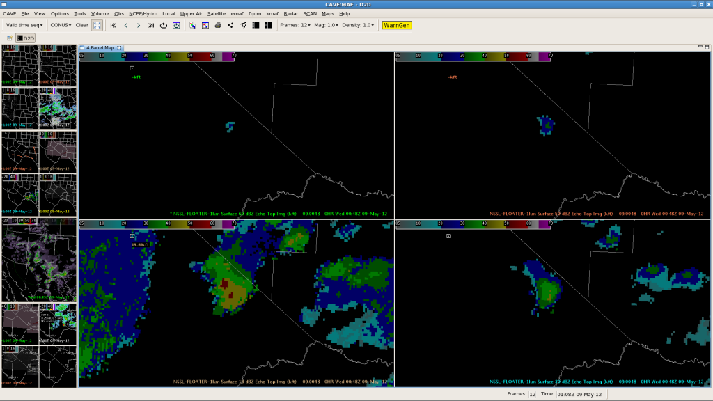
MRMS echo tops data depicted signals associated with a t-storm with hail.  Strong signals are depicted at 0046Z at the 18 dbz and 30 dbz levels (lower left and lower right) with smaller signals noted at the 50 dbz and 60 dbz levels (upper left and upper right).  Although the signals at the 50 dbz and 60 dbz levels are small in area, they represent 50 dbz to 32 kft and 60 dbz to 26 kft which are significant levels for severe hail.

AMS

Tags: None

MAF Mesoscale Desk @ 01Z

23Z GOES nearcast for 01Z supports strong updraft potential for the Brewster county storms.  Legacy Hail algorithm maintained 2 inch potential for a couple scans, so the potential for severe size hail is likely to continue.  This hail threat should continue through 03Z.  EMs and other decision makers should continue to monitor for potential warnings and statements.

Tags: None

MAF Meso Update 0044Z

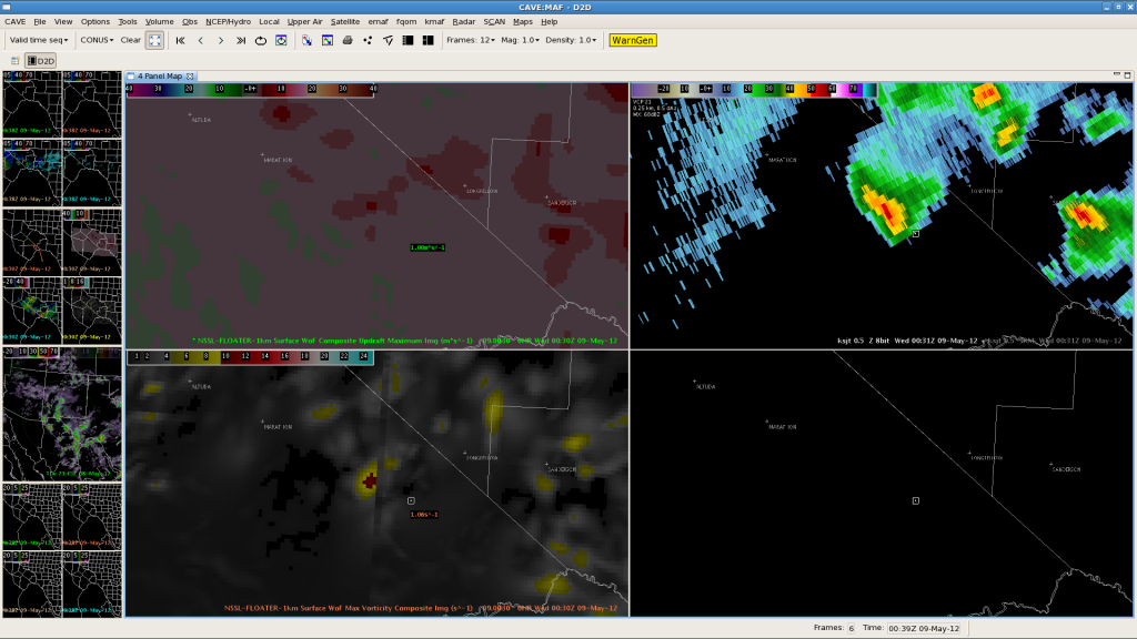
Not a whole lot going on this evening.  However, 3D VAR (see image below) still depicting weak signals of updraft (upper left) and vorticity (lower left) with a garden variety t-storm west of Longfellow, TX (reflectivity in the upper right).

AMS

Tags: None