Live Blog – 16 June 2010 (5:15pm)

Ugh!  Notifications on AWIPS break again, and it takes us about 45 minutes to get them working again.  The fragile system continues to move along for now.

But in the meantime, we’ve been working two CWAs:  Sterling (LWX) and State College (CTP).  Only our LWX folks have been issuing warnings, SVRs, mainly for wind severe criteria wind (60 mph).  The LMA data has been used as well.  CI detections have been outside of both CWAs.

Greg Stumpf (EWP Weekly Coordinator, 14-18 June 2010)

Tags: None

Outlook – 16 June 2010

A severe weather episode is expected over our Washington DC Lightning Mapping Array (LMA) domain, so we will be operating in that area.  An upper level trough and associated surface cold front over the central Appalachians, along with a tongue of very moist unstable air to the lee of the mountains are the primary ingredients for severe weather today.  0-6 km shear will exceed 30 kts over the domain, and increase to above 40 kts over central and northern Pennsylvania.  0-1 km shear will be adequate (20 kts), and CAPE will be in the 1000-2000 J/kg range.  A lee trough has set up, and the first wave of severe thunderstorms is expected to affect our CWAs (Sterling VA – LWX, and State College PA – CTP) around 20 UTC, and should be through around 23-00 UTC.  Unless severe weather is ongoing in two CWAs after dinner, we will break off two of the forecasters to do the 5/24/08 archive case, while the other two will remain issuing warnings and watching the GOES-R products.  Otherwise, we will conduct the archive event on Thursday in an afternoon shift with two forecasters, and an evening shift with the other two forecasters.

Greg Stumpf (EWP Weekly Coordinator, 14-18 June 2010)

Tags: None

Daily Summary – 15 June 2010

We conducted another long IOP over the Ohio Valley, alternating between the forecast offices in Paducah KY, Indianapolis IN, Louisville KY, and finally Wilmington OH.  The event was characterized by an advancing MCS with a bowed linear structure, and isolated supercells in advance of the line.  Our teams issued a number of Severe Thunderstorm Warnings and a few Tornado Warnings, although there were no official tornadoes reported in the SPC log.  Most of the threat was for severe wind (or barely-severe wind), of which we have only a few possible MRMS products that could help.  In fact, one of the biggest comments we’ve gotten regarding development of new products is to add some MRMS products that can help with severe convective wind warnings.  This might include a mid-altitude radial convergence (MARC) product.

For the GOES-R CI products, there was little help even though most of the area was cirrus free.   The GOES-R folks will be looking at this case as a possible failure mode case.

Greg Stumpf (EWP Weekly Coordinator, 14-18 June 2010)

Tags: None

Live Blog – 15 June 2010 (7:40pm)

Getting ready to wrap up operations tonight.  Currently, IND is winding down with the remnants of the advancing squall line/mcs in the NE part of their domain.  LMK transitioned from isolated storms in the eastern CWA to the squall line in their western CWA.  The isolated storms were “handed off” to ILN and warnings continue on them.  So far, these storms have only produced hail and wind reports, with the most being an 82 mph gust measured.  One brief tornado was reported early on the IND storms.

Our forecasters are starting to fill out both the GOES-R and MRMS surveys, and we’ll do a replay of their warnings along with the NWS warnings to finish the shift.

Greg Stumpf (EWP Weekly Coordinator, 14-18 June 2010)

Tags: None

Live Blog – 15 June 2010 (6:50pm)

Around 615, we switched the PAH WFO to ILN (Wilmington OH), as the isolated supercells ahead of the line were starting to come into the western edge of their CWA.  We have several isolated supercells out ahead that IND has issued several TORs, as well as a rapidly advancing squall line surging behind the supercells.

Greg Stumpf (EWP Weekly Coordinator, 14-18 June 2010)

Tags: None

Live Blog – 15 June 2010 (5:25pm)

We continue with an IND and PAH setup, but we might break one of the forecasters away from PAH to cover LMK.

IND has now issued a TOR on a new supercell to the east of the previously TORed storm.  Velocity is nt the greatest, but the reflectivity data shows a nice dBZ “ball” on the tip of the hook.

Greg Stumpf (EWP Weekly Coordinator, 14-18 June 2010)
Tags: None

Live Blog – 15 June 2010 (3:35pm)

For the first hour, our IND team has been issuning warnings on a storm that just entered the west side of their CWA – mostly for hail.  They will continue as that CWA

We’ve moved out LMK folks to PAH (Paducah) CWA, as storms are now affecting that area.  The floater domain does not cover the Missouri counties of PAH’s area, but that is ok, since most storms have cross the river now.  We may eventually move them back to LMK later today.

Technical note:

Thanks to generous help of Jordan Gerth and Ben Baranowski, we have finally licked the slow loading issues with our experimental grids on AWIPS!  The NFS mounted eSATA drives were running block size restrictions on data transfer, and we increased that rate.

Greg Stumpf (EWP Weekly Coordinator, 14-18 June 2010)

Tags: None

Outlook – 15 June 2010

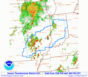
We are planning to work the event that is highlighted with an SPC Moderate Risk in Central Indiana south through central Kentucky and there already as a Severe Thunderstorm Watch in effect.  There is sufficient deep layer shear, as well as some decent low-level shear for rotating storms, but the main threat today appears to be high wind.  This will be a good example of how we might be able to use some of the MRMS products for wind warnings, which we haven’t had much experience with yet this spring.  So we will start with localizations for Indianapolis IN (IND) and Louisville KY (LMK).

In addition, the GOES-R convective initiation products should get a good work out today, as the area covered by both CWAs is essentially cirrus free at the moment!

Greg Stumpf (EWP Weekly Coordinator, 14-18 June 2010)
Tags: None

Daily Summary – 14 June 2010

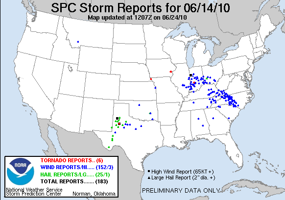
We spent most of the day, as usual for a Monday, training our new set of visitors about the various data sets we will be working with this week.  After wards, we conductive a “semi” intensive operations period with one workstation pair devoted to the central Oklahoma data, and the associate special total lightning products.  The other workstation pair was devoted to the LUB WFO, looking as a few severe storms there.  This was a very low key IOP, designed primarily to give the new forecasters some familiarity with the new products and issue a few practice warnings.  Nothing of real significance occurred in either CWA.  Finally, the forecasters took both the “pre-operations” MRMS survey which inventories several aspects of their warning decision practices, and the lightning survey.

Greg Stumpf (EWP Weekly Coordinator, 14-18 June 2010)

Tags: None