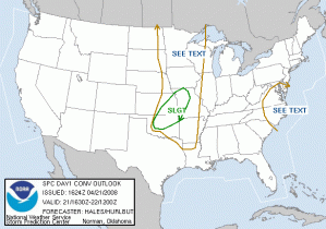
This is the first day of operations during our shakedown week. Because we don’t have any visiting forecasters this week, and we are still prepping the various systems for next week, we are going to attempt to run all three experiments today. Normally, the gridded probabilistic warning experiment would not run if there were Central Oklahoma storms affecting the PAR and CASA domains.
Looking at the 1630 SPC DY1 outlook, there is one SLGT RISK area, but two different regimes, north versus south. Basically, the southern part of the risk area is highly conditional as there is a very strong cap over Oklahoma. A dryline/cold front triple point has set up near Elk City, and there could be enough convergence to overcome the capping inversion. If storms develop, they have the potential to be high-end hailers for several hours. There is also a small chance for tornadoes, however, the shear isn’t the best. Mesoscale accidents might be the rule to squeeze out a tube or two. The northern part of the SLGT RISK area is more likely to see convective initiation before 02 UTC.
So, for today, we intend to start our Intensive Operations Period (IOP) at 5pm. The gridded warning experiment will focus on the areas E-KS and W-MO, but because this is a shakedown week, our domain may “float”. If storms develop in Oklahoma, we will initiate PAR and CASA operations as well, and possibly move the gridded warning operations to the same domain. If this event were to happen during a non-shakedown week, gridded warning operations would cease as PAR and CASA operations would begin, provided the cap breaks.
From 2-5pm, we continue to test systems and get things ready. If this were a non-shakedown week, this time would be spent training visiting forecasters on the systems and running archive case playback.
Greg Stumpf (EWP Weekly Coordinator, 21-25 April 2008)

