Wed 19 May 2010: Operations Update 7:40 pm CDT

Team 1:  Storms moving out of OUN localization and into Tulsa. TOR warning continues for storm near Guthrie, OK, velocity signature noted from KVNX radar. Storm has slowed movement towards the east.  Also watching storms in NW OK in Woodward County.  SVR warnings for probable 1 in and larger hail.  Reflectivity at -20 C nearing 60 dBZ.  (Overshoot product is having problems connecting with AWIPS; possible that GRIB2 products are not being created at the current time)

Team 2:  TOR and SVR warnings for McClain and Cleveland counties for storm moving through Noble, OK.    Also maintaining TOR and SVR warnings for storm that moved through Duncan, OK in Stephens County.  May let the tornado warning expire for Cleveland County storm as rotation track products appears weak and velocity signature doesn’t appear as significant.  Perhaps has become outflow dominant.

Kristin Kuhlman (GOES-R/PGLM Principle Scientist)

Tags: None

Live Blog – 19 May 2010 (6:45pm)

Team 1:  Continuing Operations with northern two tornadic storms.  Stillwater storm appears to be cycling with new circulation forming further south as old one occludes.  Baseball size hail still expected in western storm with 60 dBZ noted at -20 C in Kingfisher/Logan Counties.

Team 2: Focus on storms from Grady to Cleveland counties. One SVR warning for storm in Lincoln County entering the Tulsa CWA.  CASA and OU prime radars are being used to examine features not seen by the 88D radars: depicting organizational features quicker particularly with cluster of cells merging in Grady County.  Storm north of Norman (in KTLX cone of silence) appears to be picking up in intensity though rotation product appears to be some what corrupted in the location.  Also examining new storm increasing in intensity near Lawton in Comanche County.

Kristin Kuhlman (GOES-R/PGLM Principle Scientist)

Tags: None

Live Blog – 19 May 2010 (5:40pm)

Team 1:  Taking all 3 northern storms (2 eastern with current TOR warnings, western storm had earlier tornado report, but appears to be dissipating at the current time).   Rotation track shows significant values with eastern storm — Tornado currently on ground SW of Marshall, OK.  Overshooting top algorithm shows detection on in Garfield County at 2210 UTC.  Bias-corrected MESH contains values much too low: 3.25 in hail reported, bias-corrected MESH reading only 1.5 in.  Normal MESH values around 2.75-3.00 in.

Team 2:  Focusing on development in SW Oklahoma.   Storms appear to be struggling, unable to reach warning criteria.  Watching -20 C reflectivity and CASA radar data on storm north of Lawton in Caddo County.

Kristin Kuhlman (GOES-R/PGLM Principle Scientist)

Tags: None

Live Blog – 19 May 2010 (4:35pm)

Team 2:  Issued a 45 min TOR warning for storm in Kingfisher County until 5:15 CDT.  Held off issuing until rotation signature picked up in strength and reflectivity notch appeared in KVNX as well.  Also, coherent signal in AzShear and MESH were noted at the time of warning.  Reflectivity @ -20 C also picked up post warning.

**Dewey county storm showed some 13 min lead time from CI product before 35 dBZ reflectivity from KTLX.    CI product showed concurrent appearance with 35 dBZ echo for storms in Ellis Co. and Kingfisher Counties.

Cu line forming along the dryline and secondary boundary (HCR?) noted from GOES satellite NW of Lawton in Comanche and Kiowa Counties.  CI product flagged area at 2125 UTC; 35 dBZ reflectivity noted at 2130 UTC from KFDR. Team 2 monitoring this region.

Kristin Kuhlman (GOES-R/PGLM Principle Scientist)

Tags: None

Live Blog – 19 May 2010 (4:10pm)

Team 1:  Continues focus on NW OK storms.   The Ellis/Woodward county storm  and the Dewey Co. V2 supercell.  They have reissued a TOR for the Dewey county storm (velocity, TVS) and maintain a SVR on the Ellis Co.   Have been using the cloud top cooling product as well as AzShear and MESH products.

Team 2:  Watching storm near Lacey, OK in Kingfisher Co.  Have decided not to issue a TOR or SVR warning as couplet is displaced from reflectivity core and see low values form AzShear products; low reflectivity at -20 C doesn’t seem to warrant a SVR for hail at the moment.

Kristin Kuhlman (GOES-R/PGLM Principle Scientist)

Tags: None

Live Blog – 19 May 2010 (3:40pm)

Both teams are working with Norman localization.

Team 1 is focusing on the Vortex 2 storm in NW Dewey County.  First issued a severe based on core values (held off longer than local WFO due to low MESH values and core reflectivity aloft) , but quickly followed with a tornado warning as the vortex2 crew and local television reported a funnel cloud.   MESH and Rotation tracks (AzShear) products are being monitored with the storm.

Team 1 will continue to focus on the Dewey County storm and storms NW of the region.  Team 2 is examining the storm in Blaine County and the area along I-40 towards the metro region for other storm initiations.

Note:  GLM Lightning data products are currently unavailable due to maintenance on the local OK Lightning Mapping Array network.

Kristin Kuhlman (GOES-R/PGLM Principle Scientist)

Tags: None

Live Blog – 18 May 2010 (8:30pm)

Group 1.  Amarillo CWA.  TOR warning continues near Stinnett, TX (see image below).  Including both mesos and hail area. SVR warning continues for storm in Dallam county in NW TX.  Examining velocity data, AzShear products and TX mesonet while preparing possible TOR warning for storm.

Group 2.   Pueblo. Maintaing 4 separate SVR warnings across CWA. Examining circulation in velocity data in Kiowa County with spotter reported funnel cloud.  TOR quickly issued with increased signature (below).  After TOR issuance spotters soon report tornado on the ground.   Difficult to determine strength of Las Animas storm further south due to distance from the radar and MRMS products slow to update w2hwt2.

Kristin Kuhlman (GOES-R/PGLM Principle Scientist)
Tags: None

Live Blog – 18 May 2010 (7:15pm)

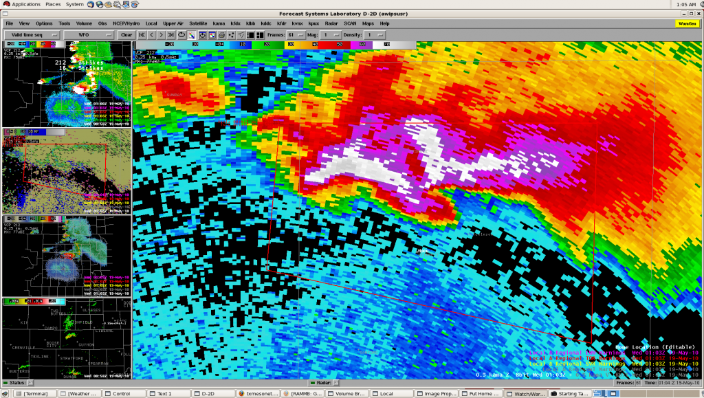
Group 1:  Both AWIPS (D2D) machines are currently having technical issues.  Higgins “drag-me-to-storm” jumps randomly with storm track disappearing and products on Tupelo are not appearing completely (only as mouse over).  No memory or CPU issues on either machine.    Due to technical issues TOR warning for Moore/Hutchinson Counties at 7:15 CDT was delayed.  (Using primarily ref/velocity data combined with azshear and reflectivity at -20C  with MESH/POSH for hail)

Kristin Kuhlman (GOES-R/PGLM Principle Scientist)
Tags: None

Live Blog – 18 May 2010 (6:50pm)

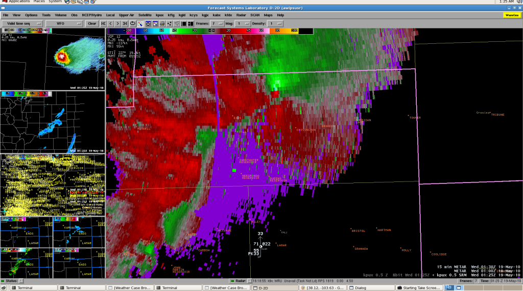
Group 1:  Amarillo Region.  Tornado Warning Continues for Moore county with tornado reported E of Dumas along Hwy 152 from Vortex2 Probe7. AzShear and Rotation track products tracking well with storm w/noted increase as storm entered the City of Dumas.

SVR warning for left-mover in Cimarron County, OK.  Fast moving storm, expecting lower values form MESH/POSH in left mover after split.  Note, anticyclonic rotation with storm as well.

Group 2:  Watching Development of new cells. Two ongoing severe warnings, believe northern warning might be a bit marginal.  Southern warning includes multiple cells developing linear structure.  Continue use of MESH product (merged AzShear product a bit noisy).

Kristin Kuhlman (GOES-R/PGLM Principle Scientist)
Tags: None

Live Blog – 18 May 2010 (5:55pm)

Group 1:  Amarillo.  Tornado Warning for meso continues and severe warning for rest of storm for baseball size hail.  Vortex2 (DOW) reports brief tornado, other mobile mesonets report funnel clouds with storm. Concerned as southern storm merges into main supercell.  As storm continues to take right turn, will only maintain tornado warning for storm and let severe expire.   0-2 km azmuthal shear product tracking well with TOR warning.  Comparing to storms depicted by HRRR and NSSL/WRF from lunchtime briefing.

Group 2:  Pueblo.  Anticipated hail size growth (to quarters) based on trend reflectivity structure to issue warning; MESH hail size matched expected growth and provided forecaster confidence to SVR warning.  First issuance of tornado warning in Crowley and Kiowa counties, using primarily velocity data combined with reflectivity structure.

Kristin Kuhlman (GOES-R/PGLM Principle Scientist)

Tags: None