Severe Thunderstorm Warning #3 – Oklahoma

SEVERE THUNDERSTORM WARNING 3 PROBS

WUUS54 KOUN 261956
SVROUN
OKC003-053-262030-
/O.NEW.KOUN.SV.W.0111.160426T1956Z-160426T2030Z/

BULLETIN – IMMEDIATE BROADCAST REQUESTED
SEVERE THUNDERSTORM WARNING NORMAN OK
NATIONAL WEATHER SERVICE
255 PM CDT TUE APR 26 2016

THE NATIONAL WEATHER SERVICE IN NORMAN HAS ISSUED A

* SEVERE THUNDERSTORM WARNING FOR…
EASTERN ALFALFA COUNTY IN NORTHWESTERN OKLAHOMA…
NORTHWESTERN GRANT COUNTY IN NORTHERN OKLAHOMA…

* UNTIL 330 PM CDT

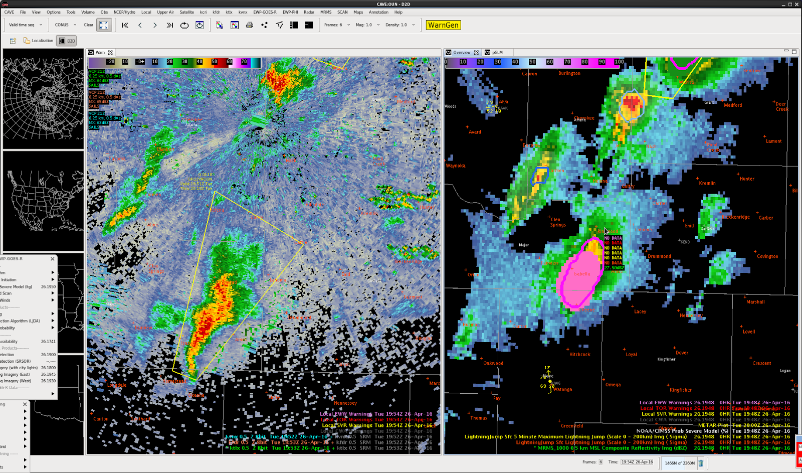
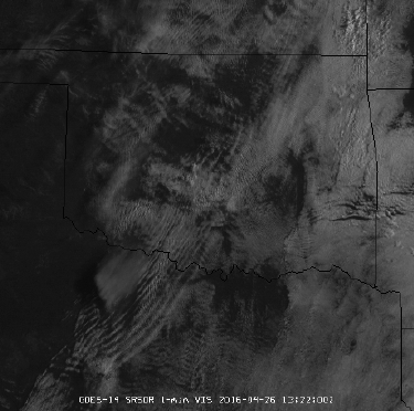
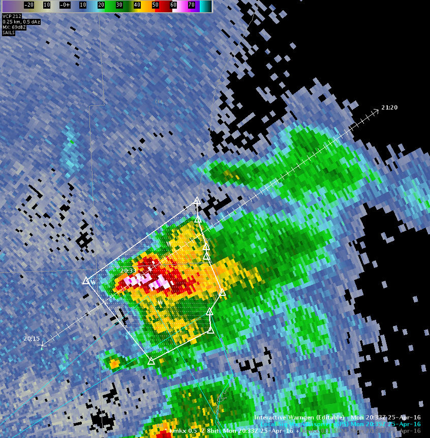
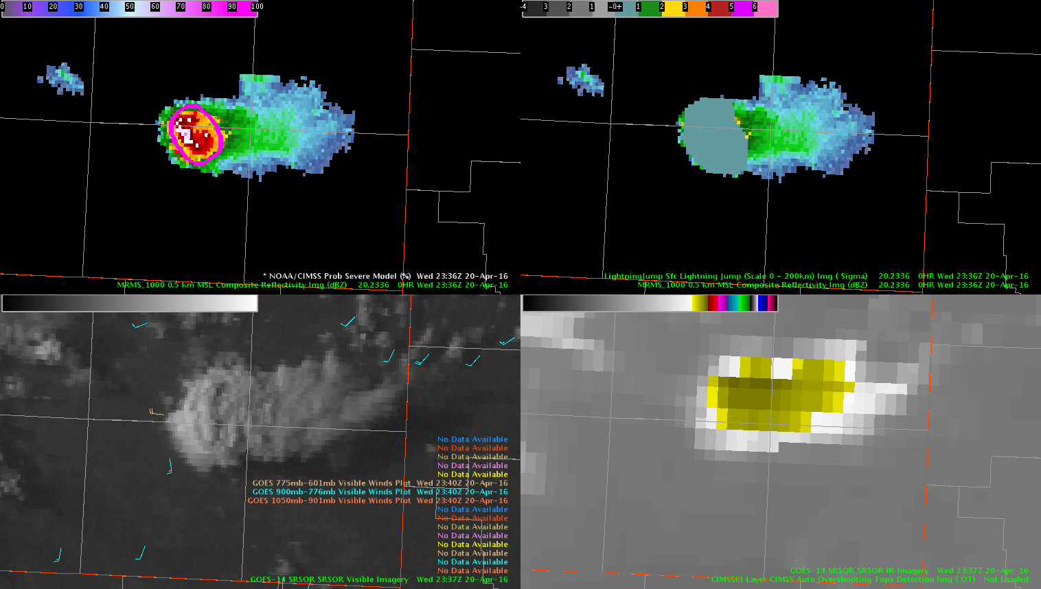
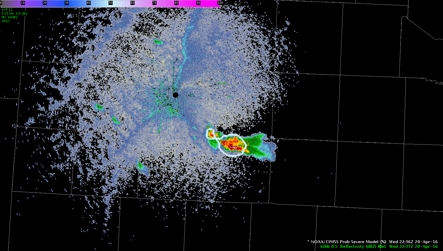
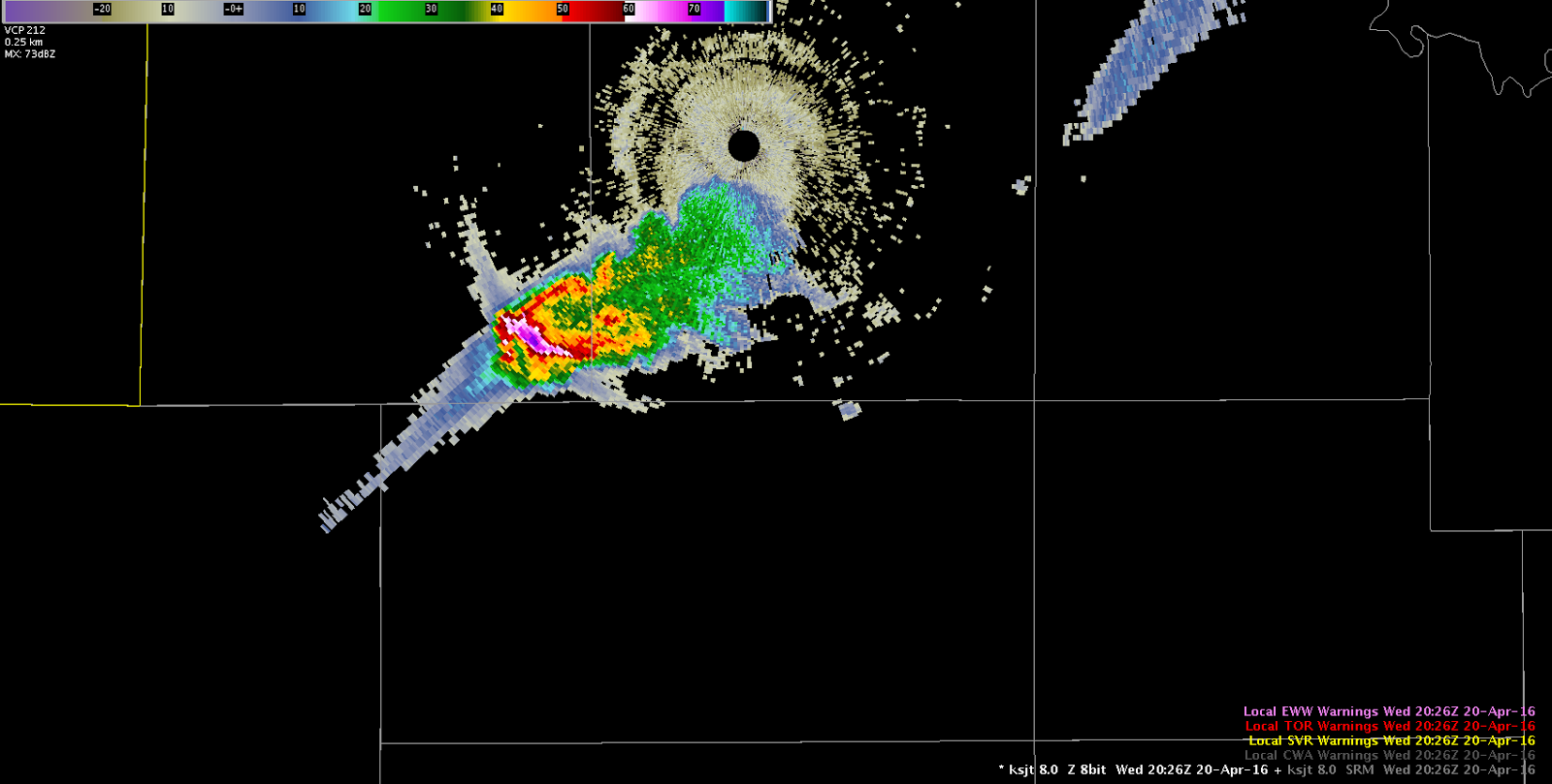
* AT 255 PM CDT…DOPPLER RADAR INDICATED A SEVERE THUNDERSTORM CAPABLE OF PRODUCING QUARTER SIZE HAIL AND DAMAGING WINDS IN EXCESS OF 60 MPH. THIS STORM WAS LOCATED NEAR MANCHESTER…OR 16 MILES SOUTH OF ANTHONY…AND MOVING NORTHEAST AT 70 MPH.

* LOCATIONS IMPACTED INCLUDE…
WAKITA AND MANCHESTER.

PRECAUTIONARY/PREPAREDNESS ACTIONS…

A TORNADO WATCH REMAINS IN EFFECT FOR THE AREA. ALTHOUGH A TORNADO IS NOT IMMEDIATELY LIKELY…IF ONE IS SPOTTED…ACT QUICKLY AND MOVE TO A PLACE OF SAFETY IN A STURDY STRUCTURE…SUCH AS A BASEMENT OR SMALL INTERIOR ROOM.

&&

LAT…LON 3679 9796 3688 9815 3700 9809 3700 9780
TIME…MOT…LOC 1955Z 207DEG 61KT 3692 9801

$$

BMS

Forecaster: Schuerman

Tags: None

Severe Thunderstorm Warning #2 – Oklahoma

Pulled the trigger on the second severe thunderstorm warning of the day. Radar signatures (60 dBZ to -20C, TBSS) began to indicate hail was possible at roughly the same time that ProbSevere jumped to around 80% and there was a 7-sigma lightning jump. I was ready to pull the trigger when I saw the radar signatures, but the ProbSevere and lightning jump gave me more confidence on the warning.

SVR2

-Toki Wartooth

Tags: None

SVR Harper and Sumner Co

KICT was down for us, but we relayed with OUN on warning (also pulled up the Topeka radar to help).

BULLETIN – IMMEDIATE BROADCAST REQUESTED
SEVERE THUNDERSTORM WARNING
NATIONAL WEATHER SERVICE WICHITA KS
233 PM CDT TUE APR 26 2016

THE NATIONAL WEATHER SERVICE IN WICHITA HAS ISSUED A

* SEVERE THUNDERSTORM WARNING FOR…
SOUTHEASTERN HARPER COUNTY IN SOUTH CENTRAL KANSAS…
SOUTHWESTERN SUMNER COUNTY IN SOUTH CENTRAL KANSAS…

* UNTIL 315 PM CDT

* AT 233 PM CDT…DOPPLER RADAR INDICATED A SEVERE THUNDERSTORM
CAPABLE OF PRODUCING LARGE DAMAGING HAIL UP TO GOLF BALL SIZE AND
DAMAGING WINDS IN EXCESS OF 60 MPH. THIS STORM WAS LOCATED NEAR
WAKITA…OR 14 MILES NORTHWEST OF MEDFORD…AND MOVING NORTHEAST AT
25 MPH.

* LOCATIONS IMPACTED INCLUDE…
ARGONIA…BLUFF CITY AND FREEPORT.

PRECAUTIONARY/PREPAREDNESS ACTIONS…

IF YOU ARE IN THE PATH OF THIS STORM…PREPARE IMMEDIATELY FOR LARGE
HAIL AND DEADLY CLOUD TO GROUND LIGHTNING. PEOPLE OUTSIDE SHOULD MOVE
TO A SHELTER…PREFERABLY INSIDE A STRONG BUILDING AND AWAY FROM
WINDOWS.

&&

LAT…LON 3732 9779 3716 9752 3699 9775 3700 9799
TIME…MOT…LOC 1933Z 216DEG 24KT 3693 9795

$$

BAJ

26SVR_Harper

The ProbSevere went from zero to 97% in less than 40 minutes.
Tags: None

Second Significant Weather Advisory Issued – Southern Wisconsin

042516 MKX SIGNIFICANT WEATHER ADVISORY 2

WWUS83 KMKX 252034
SPSMKX

SPECIAL WEATHER STATEMENT
NATIONAL WEATHER SERVICE MILWAUKEE-SULLIVAN WI
333 PM CDT MON APR 25 2016

WIZ060-065-066-252115-
OZAUKEE WI-WAUKESHA WI-MILWAUKEE WI-
333 PM CDT MON APR 25 2016

…SIGNIFICANT WEATHER ADVISORY FOR SOUTH CENTRAL OZAUKEE…
NORTHWESTERN MILWAUKEE AND NORTHEASTERN WAUKESHA COUNTIES UNTIL 415 PM CDT…

AT 333 PM CDT…DOPPLER RADAR WAS TRACKING A STRONG THUNDERSTORM OVER NORTHERN MILWAUKEE…MOVING NORTHEAST AT 30 MPH.

HALF INCH HAIL AND WINDS IN EXCESS OF 40 MPH WILL BE POSSIBLE WITH THIS STORM.

LOCATIONS IMPACTED INCLUDE…NORTHERN MILWAUKEE…MENOMONEE FALLS…MEQUON…WHITEFISH BAY…BROWN DEER…FOX POINT…BAYSIDE…RIVER HILLS AND GLENDALE.

PRECAUTIONARY/PREPAREDNESS ACTIONS…

TORRENTIAL RAINFALL IS ALSO OCCURRING WITH THIS STORM…AND MAY LEAD TO LOCALIZED FLOODING. DO NOT DRIVE YOUR VEHICLE THROUGH FLOODED ROADWAYS.

&&

LAT…LON 4314 8790 4312 8790 4309 8799 4318 8808
4326 8791 4324 8791 4321 8790 4320 8790
4316 8788
TIME…MOT…LOC 2033Z 238DEG 25KT 4318 8800

$$

BMS

042516 SIGNIFICANT WX ADVISORY PROB SEVERE 2

Second Significant Weather Advisory issues for thunderstorm to the north of first Significant Weather Advisory. MESH is now over 0.50″ with Prob Severe at 35%. Went for half inch sized hail and winds in excess of 40 MPH with these. Lightning being presented at 2.0 Sigma for these thunderstorms as they are heading off shore.

Forecaster: Schuerman

Tags: None

ProbSvr gives good lead time

Looking at the use of prob severe in providing lead time. At 23:36z a report of ping pong ball size hail.

Analysis of prob severe and lightning jump 20 minutes before at 23:16z , shows the probSvr displaying 91% chance of severe, 46kts shear, MU cape 947, Mesh 1.07″, Growth rate strong: glaciation: strong, flash rate 28/min and 1 signa jump.

20 minutes later at 23:36z:  90% chance of severe, 49 kts shear, Mu cape 1157, Mesh 1.93″, Growth rate:strong, Glaciation: strong, 0 signa. ( however, jump did stay at 1 during 20 min duration.)

One report of ping pong ball size hail at that point.

Prob severe may be a good factor in issuing an early warning for a severe storm.

-thunder

ProbSVR20minout

ProgSvrPingPongHail

Tags: None

Storm Southeast of LBB’s RDA

Storm development has occurred southeast of the Lubbock, TX RDA in the Texas Panhandle.  While initially the all-tilts reflectivity looked promising, PROBSvr continued to indicate marginal severe potential.  Combine this with no significant lightning jump and low flash density on the PGLM array, the decision was made to hold off on a warning for now.LBBRadar


Tags: None

Development of Sig Prob Severe in the Future?

Once again prob severe provides ~10-15 minutes of lead time using ~75% over typical radar thresholds. After we issued the warning we noticed signatures suggestive of significant hail sized (e.g., persistent deep TBSS, sidelobe contamination, transient BWER). This raises the question, could criteria be adjusted in the algorithm to provide sig severe guidance? This could be very useful operationally for the most high impact events that cause the most property damage and threat to life.

TBSS

-dryadiabat

Tags: None