Ultimate CI

Visiting scientists and NWS forecasters visiting the EWP this week have begun looking at real-time data with the promise of some exciting weather over OK this evening. We are currently examining the SATCAST and UWCI products in combination with the multi-radar multi-sensor (MRMS) and PGLM products to anticipation convective initiation. The participants have worked together to develop what has been so lovingly called the “ultimate CI” 4-panel display within AWIPS. The 4-panel (shown above) includes the following products that are linked to the nowcast and detection of CI… Starting from top left and moving anti-cyclonic (clockwise) we have the visible with SATCAST, visible with UWCI, visible with MRMS reflectivity at -10 C, and finally visible with PGLM and NLDN lightning detections. The 4-panel has been saved as a procedure that forecasters can now load very quickly within their AWIPS D2D workstations throughout the rest of the week. Future visitors will have this available as well. This helps demonstrate the ability to combine these unique datasets from multiple sensors into one effective decision support tool.

Posted by Chris Siewert at 3:38 PM (from the GOES-R blog).

Tags: None

EWP 2011 Week #3

Week #3 is underway with our guest NWS forecasters:  Jason Jordan (WFO Lubbock, TX), Daniel Leins (WFO Phoenix, AZ), Bobby Prentice (WDTB, Norman, OK), Pablo Santos (WFO Miami, FL), and Kevin E. Smith (WFO Paducah, KY).

Morning consisted of our normal Monday training session, followed by getting used to the new products on a displaced real-time case.  As of 3:30pm, everyone has switched over to looking at real-time data, as convection is developing in western Oklahoma.

— Travis Smith, weekly coordinator

Tags: None

Live Blog: 11 May 2310 UTC – 3DVAR

Composite reflectivity and wind vectors at 1.5 km MSL (upper left), Max Vorticity in the vertical column (upper right), max updraft of about 28 m/s (lower left), and 30-minute track of maximum vorticity (lower right).

Brian and Scott have been watching a storm in E Colorado that produced hail and wind damage.  They commented that the 3DVAR analysis seems to produce a very realistic wind field at the 1.5 km level for the storm of interest.

Tags: None

Live Blog – 11 May 2011 – 2108 UTC

Brian is noting a good relationship between the 3DVAR  vorticity field and low-level radial velocity data on the tornado-warned storm in NE Cleveland/Pott. Counties.

3DVAR vorticity contours and simulated reflectvity for a tornado-warned storm in NE Cleveland Co., OK
Tags: None

3DVAR and CG lightning

1-hour max updraft versus 1-hour observed CG lightning strikes

Brandon has been observing storms in Oklahoma with the 3DVAR and lightning products.  The plot above shows a strong relationship between the maximum updraft intensity over the previous 60 minutes with CG lightning strikes over the same time period.

Brandon also noted that is is difficult to correlate the updraft intensity with reflectivity cores aloft due to the temporal lag in the 3DVAR products.

— Travis Smith

Tags: None

Live Blog – 20 May 2010 (4:15pm)

Dave has set up an 8-panel set-up that he likes:

  • RotationTrackML30min
  • RotationTrack30min
  • AzShear0-2
  • AzShear3-6
  • MESH
  • EchoTops50
  • Reflectivity_-20C
  • Base-tilt of reflectivity from nearest radar

Gives a nice overview of all the main parameters that he is interested in monitoring, and makes for fast toggling.

Volume browser loading was slow in HWT — may be faster in real AWIPS.

Travis Smith (EWP Weekly Coordinator, 17-21 May 2010)

Tags: None

Outlook – 20 May 2010

We will focus on the ongoing area of convection (tornado watch) in the FWD CWA for the afternoon.  Later in the day, convection is expected to move into the Huntsville LMA domain.  The current plan is to concentrate on the FWD area until around 5 or 5:30pm, take a dinner break, and then switch to the N. Alabama domain for evening operations.

There are two tornado-warned storms along an east-west boundary in the CWA at the start of operations (3pm).

Travis Smith (EWP Weekly Coordinator, 17-21 May 2010)

Tags: None

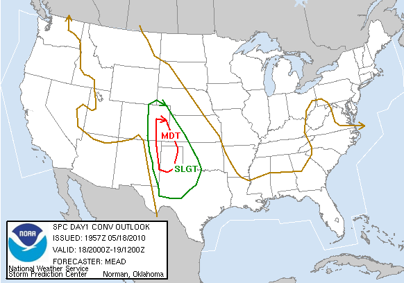
Outlook – 18 May 2010

SPC has issued a Moderate Risk for SE Colorado and the TX/OK panhandles.   HRRR is indicating early initiation in SE CO and a later show in SW KS and the panhandles.

Other notes from the discussion:

  • 2345 and 0015 are GOES-R gaps (0015 is calibration, 2345 is full-disk, which happens every three hours).   Otherwise the data come in every 15 minutes.  0Z is a bad time to start looking at CI products
  • Due to lots of cirrus over the area, the CI products may not see too much use today.  However, expect GOES to operate in rapid-scan mode due to the Moderate Risk.

Travis Smith (EWP Weekly Coordinator, 17-21 May 2010)

Tags: None