An official website of the United States government
Here’s how you know
Official websites use .gov A
.gov website belongs to an official government
organization in the United States.
Secure .gov websites use HTTPS A
lock (
) or https:// means you’ve safely connected to
the .gov website. Share sensitive information only on official,
secure websites.
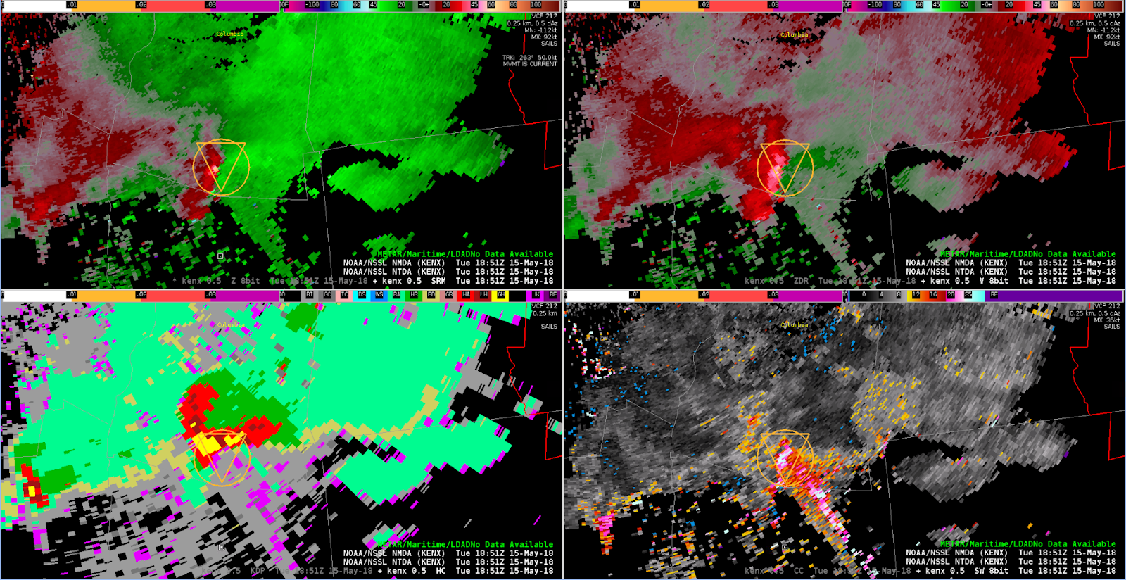
In the ALY case, a TBSS adjacent to a weak hook caused the NMDA marker to be displaced south of the meso. On the next scan, once there was a space between the hook and the TBSS, the marker jumped back north to the correct position, co-located with the NTDA marker. The NMDA ID remained consistent even with this jump.
L to R, top to bottom: 0.5 / 0.9 / 1.3 deg SRM, 0.5 deg Z with NMDA and NTDA0.5 deg SRM with NMDA and NTDA
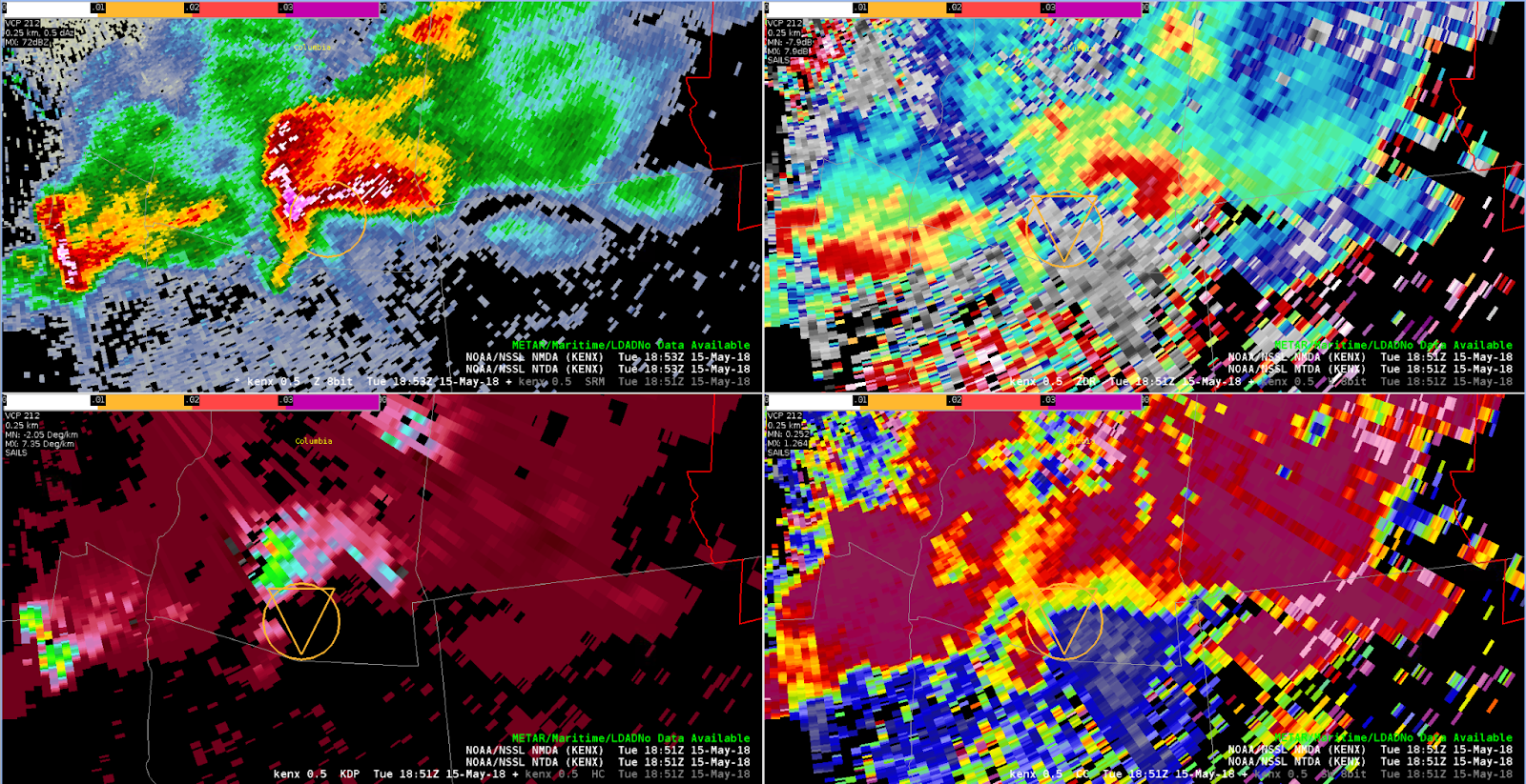
A well developed supercell was moving ESE south of Albany. The radar is not in a great location for this storm; while close, it is having to shoot through a very significant hail core. This is creating a very large TBSS coincident with the location of the low level mesocyclone. The NTDA is showing probabilities generally less than 60% (and in many cases, between 30 and 40%), but I expected to see higher numbers. Suspect the lower probs are due to velocity issues related to the TBSS. Subjectively, I would definitely have a Tornado Warning out for this storm.
Here is a case with splitting cells. Initially there are two weak mesocyclone detections associated with the cyclonic south flanks of each cell. You can tell this is a strongly sheared environment by downshear stretching of the cells. Velocity indicates elongated mirror image shear zones on each side of each updraft (like the rock in the stream).
These are sneaky because they can be vertically correlated (since the shear with the obstacle flow is deep enough to show up in multiple cuts). I’m impressed that there is a sanity check (neighborhood check?) in which the number of detections is limited. The panels to the right of the figure above show continued 2D shear with perhaps the beginning of a mesoscylone. Even if there was a well defined mesoanticyclone, the algorithm is not configured to catch the negative shear.
This was a less than ideal 0-3 km shear orientation for this QLCS overall, but a section of the line to the northeast of KDGX (Jackson, MS) did have a slightly more favorable orientation.
Above we see an initial NMDA detection at 2039 UTC associated with the tightening couplet. There is NTDA detection to the northwest associated with a broader cyclonic circulation that may at first looked like a developing bookend vortex, but this didn’t last given semi-discrete storm mode.
As the couplet starts to pivot anticylonically and tighten a bit, we see agreement in placement with the NMDA and the NTDA. The >20% shown in the NTDA legend refers to a slider setting to filter out lower probabilities. Having the filtering feature is great and made even better by having the legend provide that extra information.
The next available time shows accurate progression of the NTDA detection with respect to the now even better defined couplet (note: the NMDA had not updated since the previous image).
Starting to see more discrete circulations that are most likely very shallow and probably too small to be well resolved at much greater range than this. The example suggests utility in having the NMDA and NTDA icons displayed together because in this situation they’re basically identifying the same features while bringing different information to the table.
For example, the NMDA is looking at the 0.5 through 1.3 cuts while the NTDA uses multiple moments (including dual pol) at the 0.5 cut and then draws upon a set of a analogs to calculate probabilities. Using the NMDA/NTDA in this fashion is sort of like using a “two model ensemble” to build confidence in detections.
Here we see multiple MDA detections along the leading edge of the convection outflow. Note that this is 0.3 degrees roughly below 1000 ft, well below the LCL:
A QLCS is moving across far northeastern Mississippi. The KGWX radar is shooting parallel to the gust front on a lengthy segment of this QLCS, which has a fairly well-defined (if not overly sharp) leading edge / shear axis. This is a case in which the NMDA is suggesting that there are multiple weak mesocyclones lined up along this shear axis, when in reality this is (mostly) just a line of forward propagating convection. At the time of this screen capture, the one NMDA detection with a higher AzShear value (in orange) does appear to be legitimately associated with a mesocyclone.
KGWX detections at 2029Z.
On the other hand, a tight circulation did develop along another QLCS segment further south, where it was intersecting the outflow from the northern segment. NTDA picked up values >50% here, and did so in advance of the circulation tightening up to the extent that it can be likely called tornadic. This was a good detection for sure.
2052Z
A weak/shallow circulation developed in Oktibbeha County MS, on a kink in the line. This feature is just to the right of the word “Oktibbeha” in the image below. However, despite there being a number of false alarms on the NTDA algorithm (including one just to the north), this feature did not generate a detection on either the NTDA or NMDA. Forecasters in our group thought that this feature, while probably unlikely to be actively producing a tornado, was probably the kind of thing you would want the algorithms (or at least the NTDA) to put some kind of small probabilities on. For the purposes of NMDA, it should be noted that this weak circulation did extend through the lowest 3 or 4 slices on KGWX.
NMDA was slow to pick up on discrete supercell development southeast of Jackson MS. Several scans later all three of these cells had a ‘medium’ to ‘high’ for AzShear Max. This may have been a latency issue or a restart of the NMDA/NTDA algorithms?
Three discrete supercells developing south and east of the main line of convection.
Multiple overlapping “low” NMDAs were observed along the leading edge of a squall line with a slightly bowed segment. Looking at SRM, aside from the northern book end, these do not appear to be anything of concern, at least not from a rotation standpoint. These very low-end detections are proving to be somewhat distracting, with the areas of stronger rotation almost hidden amongst the excessive amount of icons.