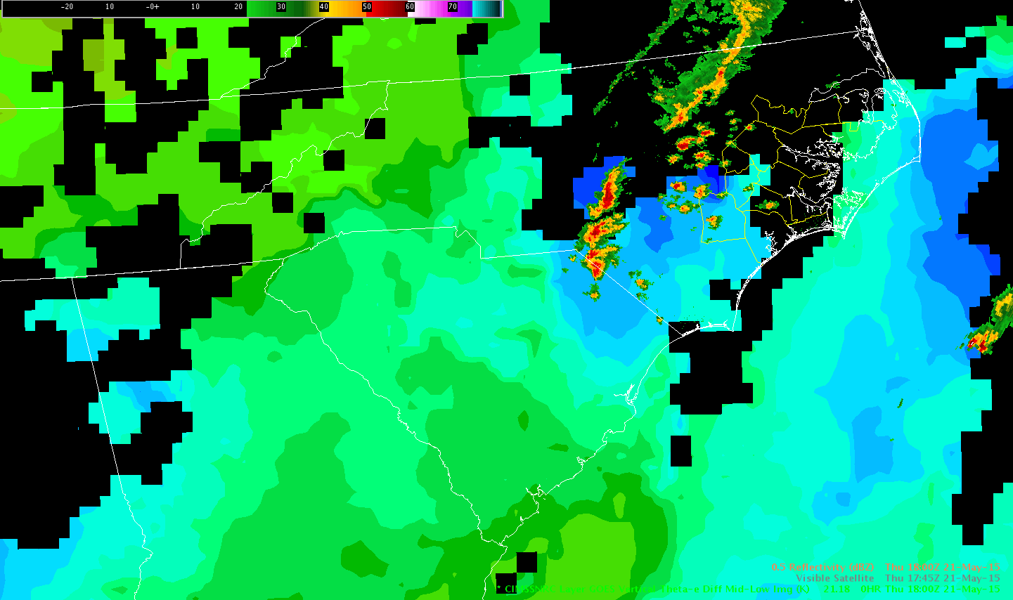
We’re keeping an eye out along the southwest portion of the cold front across ILM CWA for convective development. So far, SRSOR shows little cu towering and the UAH Convective Initiation is keeping probabilities around 50% or less.

George
Official websites use .gov
A
.gov website belongs to an official government
organization in the United States.
Secure .gov websites use HTTPS
A
lock (
) or https:// means you’ve safely connected to
the .gov website. Share sensitive information only on official,
secure websites.

We’re keeping an eye out along the southwest portion of the cold front across ILM CWA for convective development. So far, SRSOR shows little cu towering and the UAH Convective Initiation is keeping probabilities around 50% or less.
George
At 1915z…a small supercell over Quitsna NC (fig 1)exhibited severe characteristics of 60-65 dbz above the -20c level and a low/mid level meso. Interestingly the small size of the reflectivity core and likely updraft volume limited lightning with the storm. The 70 percent eni lightning detection efficiency in the area could also have been a factor. This is seen in the -999 sigma lightning jump (fig 2) and only 9 cloud flashes in eni and no cg (fig 3).
It was not until 1938 that the lightning jump algorithm showed a 2 sigma jump (fig 4)…and then 1940 a 3 sigma jump that the algorithm itself would have alerted to a severe cell (fig 5)
Prob severe at 1915z was only 40 percent (fig 6)…because heavy cirrus from storms to the west negated the satellite growth algorithm. The algorithm was consequently all weigthed towad mexh. It was not until 1925z that the mesh got big enough to have the prob severe go over 60 percent (f ig 7).
Due to the slow lightning growth…DTA were also slow in in detecting this storm. Not until 1930 for a significant DTA (Fig 8), and not until 1950z for a dangerous DTA (fig 9).
Fig 1

Fig 2

Fig 3

Fig4

Fig 5

Fig 7
Fig 8

Fig 9

There have been several storms in South Florida with ProbSevere greater than 80% and ENI Dangerous Tstm Alerts. This corresponded with lightning jumps as seen in the bottom image, but were quickly followed by equally rapid drops in lightning. ProbSevere mouse-over info briefly indicated strong Norm Vert Growth Rates and Glaciation Rates. The MESH values are topping out around or just above 1 inch. If there is any severe weather at the surface it is likely very short-lived – maybe 10 minutes or so. Nearly all of these cells are in unpopulated areas. In this environment we are not seeing sustained updrafts.The ProbSevere and ENI Alerts still help you focus in on the strongest storms…but in the context of everything else are not indicators (so far today) that a warning should be issued.
-snowstrm


Radar imagery showing a storm intensifying across central Miami-Dade county (highlighted by the white arrows) due to a collision from outflow from convection to the northwest. As this storm intensified, the prob severe increased from 7% to 79% in two volume scans…as seen in the below images. 


As a line of strong to severe storms approached from the west, anvil cirrus continued to spread east over the forecast area. Once storms moved into the forecast area, much of the ProbSevere model analysis included N/A for glaciation and growth rate under the cirrus umbrella. ProbSevere was driven mainly by MESH, offering little lead time over the radar data use alone. The LJDA showed no sigma change or signal. Upon further inspection, the storm produced very little raw ENI lightning.
Real world: WFO Wakefield issued a tornado warning on this storm. No reports of weather with this storm as of 2022Z.
Rocky.
Cirrus tophat:

Prob Severe sampling showing N/A
Reflectivity by 1927Z with ENI Cell lightning data:

Developing storms interacted with north/south sea breeze boundary across ILM. Initially, the 1-min SRSOR showed towering cumulus and the cloud features showed intense updrafts. At first, ENI data indicated no/little cloud flashes. However, within 1 to 2 minutes, lightning rates increased dramatically (60 to 70 per minute). ProbSevere jumped similarly as well, from less than 20 percent to a maximum of 81 percent. Finally, using the KLTX radar data, a very impressive hail core aloft was noted with 70 dbz up to -20C (25,000 ft). The combination of the SRSOR data showed that the particular cell was one to watch, the rapid increase in ENI data and ProbSevere were excellent precursors to what eventually showed up in the KLTX data.


George
Example of cell tracking ‘handoff’ that affects accuracy of lightning time series
southern Bladen Co / northern Columbus Co around 1935Z to 1955Z.
three images show the sequence below.
This was a cell warned for severe hail at 1930Z
Tracking ‘split’ happened about the time that a non-severe, less-organized region of convection overtook the discrete, severe cell from the west.
1936Z:

1946Z:

1954Z

-Holaday
CI imagery across western Miami-Dade county highlighted in orange peaked at 86% at 1845z. Over 30 minutes later at 1919z, a strong thunderstorm developed in this same area as seen in the below radar image. This is further justification that the CI tool seems to work really well in pulse environments. 

At 1842 and 1843Z, the LJDA signal 7 and 5 sigma jump, respectively, which caused me to take notice (see image #1 below west of “Wayne” county name). On closer inspection, the raw data suggested a movement from 10-13 strikes per minute to near 20, then into the lower 30s over those 2 minutes. A radar image is also included from the case depicting the storm collapsing and never producing significant weather. Reflectivity data was unremarkable and ProbSevere remained in the 30s. No action was taken by the warning operator.
Is it worth using total strikes as a background filter when STD values are so small, and total strikes are < 20, in order to reduce FARs?
Rocky


The Nearcast model vertical instability product had cloud/missing data issues, but still was able to provide some good timing on the eastward progression of the front through the Morehead City forecast area. Note the light blue pixel area (unstable), albeit only a small group of pixels, shifting east in the loop below.
This timing can help with severe weather staffing at a forecast office and with DSS messaging to customers.
Rocky