

Although vLAPS appears to be doing well with the CAPE/CIN fields today, the composite reflectivity from the vLAPS continues to over forecast the amount of convection across the domain area.
-JB
Official websites use .gov
A
.gov website belongs to an official government
organization in the United States.
Secure .gov websites use HTTPS
A
lock (
) or https:// means you’ve safely connected to
the .gov website. Share sensitive information only on official,
secure websites.

Although vLAPS appears to be doing well with the CAPE/CIN fields today, the composite reflectivity from the vLAPS continues to over forecast the amount of convection across the domain area.
-JB

The storms developing in central and western KY are developing within the SBCAPE maximum of the vLAPS. This would indicate that as storms continue to move to the southeast that they should continue to be at least near severe into the Nashville, TN CWA.
-JB
Since convection has not fired up yet in the Tennessee/Ohio Valleys, I was able to spend some time analyzing the pre-storm environment with the products we’re testing this week. The first on the list is the NSSL-WRF simulated IR/WV satellite product; I pulled up a four-panel with simulated on the left and actual on the right (below). As of ~1845Z-19Z, the simulated imagery was depicting isolated convection across southern KY and middle TN too soon but not necessarily entirely inaccurate. It is accurately honing in on the cloud cluster centered over IN-IL-IA/MO border, albeit overdoing the coverage and coolness of the cloud temps, as has been observed all this week. Interestingly, it is not picking up on the cirrus overspreading the Ohio Valley and into TN. Accounting for all of this, I can adjust accordingly and remain confident in using this product to develop a mesoscale forecast.

Moving to the next item on the list, I pulled up a four-panel of the NearCast analysis products with 500mb theta-e in the top left, 780mb theta-e in the bottom left, theta-e difference in the top right, and 900-700mb PW in the bottom right (below). A surge of mid-level instability can be seen diving into TN and is also evident in the difference product with the gradient diagonally stretched from the NW corner of TN to the SE corner. PW values/moisture surge matches with where storms are quickly firing up in western and south-central KY. When analysis data is available for these NearCast products, I really like to use these to diagnose and forecast.

Next, I loaded the same four-panel with the NearCast forecast and took a screen shot of the 2-hour forecast (21Z, below). Unfortunately, missing data over the region of interest exists with the 500mb theta-e and theta-e difference products. However, I can still see the lower-level instability and moisture axis draped across western KY into TN in the 780mb theta-e and 900-700mb PW, respectively. Given the success of these products so far, I have good confidence in utilizing the forecasts to accurately predict where the greatest threat will be, given other atmospheric conditions line up for convection as well.

Looking at GOES-14 SRSOR vis imagery and overlaying the CI product, a 60% probability popped up in western KY (below) and within a half hour, storms developed in the vicinity. There was a false alarm 60% probability just to the west of Paducah, KY, probably due to the thin cirrus streaming over a CU field there. In OHX’s CWA, no reliable indications of convective initiation has appeared yet. As for the SRSOR product, I am once again very pleased to have this data available to more accurately assess and see the evolution of the regional atmosphere.

Below, I overlaid OTD on IR SRSOR imagery and thus far, no detections.

~Linda

Using LAPs for pre storm enviornment today. I decide to play a little with the different fields in LAPs other than just CAPE. I ran into a pixelation issue that is going on with these gif. This pixelation was not present in the LAPs wind fields that were loaded up.
extra picture included to show the image.

At the same time there does appear to be a problem with the reflectivity fields which Danielle noticed as well.
Grant H.
In conjunction with the storm splitting signal seen in the 16Z OUN-WRF, the 18Z OUN-WRF shows two distinct supercells in the western portions of the Goodland CWA by 23Z with a third developing shortly afterwards.

Based on this data, I would be more concerned than before about the threat for tornadoes and stronger winds in addition to simply hail because of the storm type likely to develop. Strong negative helicities correlate with the expected potential of left moving splits that also may contain severe hail.
These signatures in the GLD CWA are the most significant signatures within the OUN-WRF domain. Based on the helicity product, only a marginal hail threat seems to be developing elsewhere.
– JRM
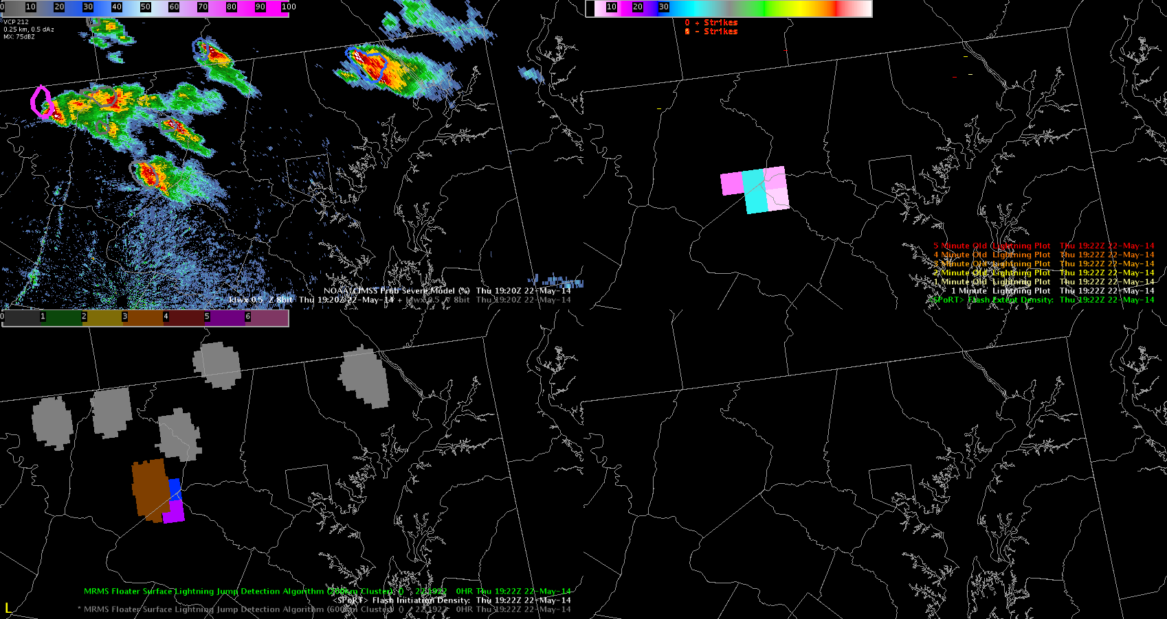
I finally got to see lightning jump data and it was so helpful. At this frame you can it has the brown color and then as I continued the loop it went to a green color. It indicated to me that this storm was intensifying and definitely got my attention. It also was trending up on the Prob Severe so at this point I would probably issue a warning. ~Vollmar
Though convection is expected to be widespread this afternoon and evening across much of the high and southern Plains regions today, only a marginal severe wind threat is expected to develop using various OUN-WRF products. The wind gust product only sporadically exceeds 40-45 kts as updrafts pulse up and down. No particular region stands out over the course of the afternoon as particularly favorable based on the wind product.

In addition, the 5 KM reflectivity product was examined, and generally, reflectivity cores aloft do not just disappear within the data. The most rapid decreases of cores aloft occur in the Goodland CWA.
– JRM

Decided to through in a pre-enviornment blog about convection over southern West Virginia and far southwestern Virginia. In this case a plume of cirrus/ cirro-stratus is not showing up in the WRF. Normally that would be rather benign. However in this case that cirrus is blocking just enough isolation to prevent storm development over both areas which is keeping storms from popping and having the time to hit the equilibrium level.
Grant H.
I have been closely monitoring the ProbSvr product today as storms have initially developed over parts of western KY. Analysis of the radar data from the OHX radar data indicates that severe weather would be likely from the storm near Fryer, but the ProbSvr to this point only has around 60% chances.
-JB


If you are following NearCast today, it shows the the Diff. Med Low Theta E that the unstable environment would start over western MD and move across the state into the Delmarva Peninsula. Behind it some more stable air will move in. It will be interesting to see if storms follow this track and move from NW to SE along the area and at the same time. ~Vollmar