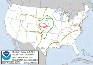
Another moderate risk day over NW and NC KS and SW NE, with a slight risk extending down into Oklahoma. The big question today is whether the cap south of I-70 will break. The operational RUC says yes, but all the SPC ensemble members and the deterministic NAM and ETA say no. But, we will be on guard for Central OK operations nonetheless.
The progs predict a strong surface cyclone in SW KS, with wrapping moisture and instability northward to the east of a dryline and around the north side of the low. Strong upslope north of the low will be a decent target for today, but the shear isn’t as great up there than points further south along the dryline. However, there is that cap to content with.
The plan is to operate a gridded warning IOP from 5-9 in Western KS and SW NE, where the initial storms develop. If the cap miraculously breaks in OK, we will shift south, and also operate the PAR. No CASA operations are expected, as the radars are not yet ready.
Greg Stumpf (EWP Weekly Coordinator, 21-25 April)


