
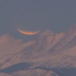
The sun rises on the Rocky Mountains as the eclipsed moon sets on December 10, 2011.
Official websites use .gov
A
.gov website belongs to an official government
organization in the United States.
Secure .gov websites use HTTPS
A
lock (
) or https:// means you’ve safely connected to
the .gov website. Share sensitive information only on official,
secure websites.
The sun rises on the Rocky Mountains as the eclipsed moon sets on December 10, 2011.

NSSL/CIMMS Sean Waugh got up early during his week at the San Francisco Exploratorium to capture the Golden Gate Bridge towers rising through the fog.
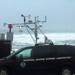
NSSL’s Sean Waugh rides out Hurricane Irene in a mobile mesonet vehicle in Morehead City, NC. His goal was to collect weather data on Hurricane Irene as it passed overhead and also test a new instrument he designed, tested and built with NSSL’s Sherman Frederickson.
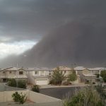
A wall of dirt engulfs the Phoenix metro area for the second time in July, 2011.
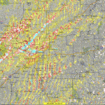
Rotation tracks of the storms in southeast Kansas and southwest Missouri on May 22, 2011 produced by NSSL’s WDSS-II: On Demand system. Brighter reds and yellows show stronger rotation.
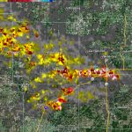
NSSL has released this image documenting the rotation tracks of the devastating tornadoes on April 27-28.
NSSL has released an image documenting the rotation tracks of the devastating tornadoes on April 27-28. Bright reds and yellows show more intense circulations.
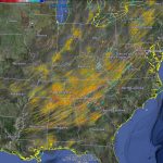
NSSL’s Warning Decision Support System-Integrated Information (WDSS-II) On Demand can be used to help confirm when and where severe weather occurs. The American Red Cross and local NWS forecast offices have used the product for disaster response and recovery, and damage surveys. This image shows rotation tracks across Arkansas from the Monday, April 25 tornado outbreak.
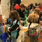
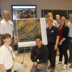
NSSL hosted a busy booth at the American Meteorological Society’s WeatherFest on January 23, 2011 at the Washington State Convention Center in Seattle, Wash. More than 4,000 people of all ages attended the interactive weather and science fair open to the public.
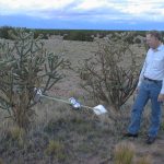
Dave Rust tries to figure out how to extract an Electric Field Meter from a cactus!