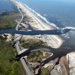
CI-FLOW total water level system prepared for test by Hurricane Sandy

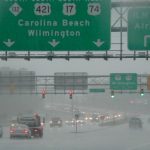
Researchers with the Coastal and Inland Flooding Observation and Warning (CI-FLOW) project are preparing for Hurricane Sandy to test their total water level system in North Carolina this weekend. The CI-FLOW system captures the complex interaction between rainfall, river flows, waves, tides and storm surge, and how they impact water levels in the Tar-Pamlico and Neuse Rivers and the Pamlico Sound in North Carolina.

CI-FLOW collects data from a computing system that combines radar and rain gauge information to create estimates of rainfall.  This information is passed on to water quantity models that simulate freshwater flows from the headwaters of the basins into the rivers; taking into account soil type, slope of the land and vegetation patterns.  Finally, water flow data is passed from river models to a coastal circulation and storm surge model that provides simulations of waves, tides and storm surge.

National Weather Service forecasters will have access to CI-FLOW during Hurricane Sandy to help them evaluate the system for application in the flood and flash flood warning process.

The CI-FLOW project is motivated by NOAA’s critical forecast need for detailed water level predictions in coastal areas and has a vision to transition CI-FLOW research findings and technologies to other U.S. coastal watersheds.

The NOAA National Severe Storms Laboratory with support from the NOAA National Sea Grant Office leads the unique interdisciplinary team including the North Carolina, South Carolina, and Texas Sea Grant Programs, University of Oklahoma, Renaissance Computing Institute (RENCI), University of North Carolina at Chapel Hill, Seahorse Consulting, NWS Forecast Offices in Raleigh, and Newport/Morehead City, NWS Southeast River Forecast Center, NOAA’s Coastal Services Center, NOAA in the Carolinas, NOAA Southeast and Caribbean Regional Team (SECART), NOAA-Integrated Ocean Observing System, Department of Homeland Security, Center of Excellence-Natural Disasters, Coastal Infrastructure and Emergency Management, Centers for Ocean Sciences Education Excellence SouthEast, Coast Survey Development Laboratory and NWS Office of Hydrologic Development.

Share this:

Techniques used at NSSL described in new book by NSSL scientist

Springer has just published a book written by NSSL/CIMMS scientist Valliappa Lakshmanan: “Automating the Analysis of Spatial Grids – A Practical Guide to Data Mining Geospatial Images for Human and Environmental Applications.”

Lakshmanan used the techniques described in the book as the basis for several valuable NSSL applications including the Warning Decision Support System: Integrated Information and NSSL: On Demand.

The book is based on a course Lakshmanan taught in Spring 2011 at the University of Oklahoma.

Here is an excerpt from the preface:

“The ability to create automated algorithms to process gridded spatial data is increasingly important as remotely sensed data sets increase in volume and frequency. Whether in business, social science, ecology, meteorology or urban planning, it has become critical to analyze and detect patterns in geospatial data and to do so with minimal human intervention. My aim with this book is to provide readers with a foundation in topics of digital image processing and data mining as applied to geospatial data sets. The aim is for readers to be able to devise and implement automated techniques to extract information from spatial grids such as radar, satellite, or high-resolution survey imagery.”

http://www.springerlink.com/content/978-94-007-4074-7/#section=1083839&page=4&locus=63

Share this:

NSSL gears up for the National Weather Festival

Getting ready to launch a balloon at the National Weather Festival

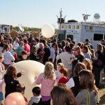
The free, public and very popular National Weather Festival will be held Saturday, November 3 from 9 a.m. to 1 p.m. at the National Weather Center. More than 4,500 people attended the event in 2011.

The unique event features hourly weather balloon launches, children’s activities, storm research vehicle displays, amateur radio demonstrations and weather related information and products.

Visitors will be allowed to tour some areas of the National Weather Center’s premier facilities, including National Weather Service Forecast operations areas. Oklahoma-based emergency response organizations will display vehicles and equipment used to respond to disasters such as tornadoes and wildfires.

About 50 storm chasing vehicles have been entered in the Storm Chaser Car Show to be eligible for prizes in four divisions: Storm Spotter, Student/Researcher, Professional, and TV Chaser.

NOAA Weather Partners and the University of Oklahoma host the National Weather Festival. Sponsors of the event include the Norman Chamber of Commerce with support from dozens of local weather and business organizations.

Share this:

Lower Atmospheric Boundary Layer Experiment

One of the Doppler Lidars at the Southern Great Plains research site.

A NOAA National Severe Storms Laboratory (NSSL) scientist is leading an experiment to collect a comprehensive dataset on vertical turbulence and thermodynamic profiles in a portion of the lower atmosphere known as the boundary layer. A number of instruments deployed in north central Oklahoma will collect data for six weeks during the Lower Atmospheric Boundary Layer Experiment (LABLE).

The unique dataset will help researchers understand turbulent processes and thus improve our ability to reproduce turbulence more accurately in numerical weather models that attempt to simulate the atmosphere.

Turbulence redistributes energy and mass in the atmosphere, and can be influenced by different surface types, horizontal wind speed and direction, and the vertical temperature structure of the atmosphere. However, there have been relatively few studies that have investigated how the vertical turbulence profile changes over short horizontal distances due to these variables.  Data collected during LABLE will also be used to derive water vapor fluxes at the top of the boundary layer, and to compare vertical motions observed by different instruments.

LABLE leverages the strong observing infrastructure currently available from the Department of Energy’s Atmospheric Radiation Measurement (ARM) Southern Great Plains (SGP) site in north-central Oklahoma.  In addition to the instruments already in place at SGP, NSSL and scientists from the University of Oklahoma deployed two Doppler lidars, a sodar, and a laser scintillometer to measure turbulence, winds, thermodynamic structure and other microphysical properties.

Share this: