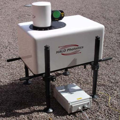
A NOAA National Severe Storms Laboratory (NSSL) scientist is leading an experiment to collect a comprehensive dataset on vertical turbulence and thermodynamic profiles in a portion of the lower atmosphere known as the boundary layer. A number of instruments deployed in north central Oklahoma will collect data for six weeks during the Lower Atmospheric Boundary Layer Experiment (LABLE).
The unique dataset will help researchers understand turbulent processes and thus improve our ability to reproduce turbulence more accurately in numerical weather models that attempt to simulate the atmosphere.
Turbulence redistributes energy and mass in the atmosphere, and can be influenced by different surface types, horizontal wind speed and direction, and the vertical temperature structure of the atmosphere. However, there have been relatively few studies that have investigated how the vertical turbulence profile changes over short horizontal distances due to these variables. Data collected during LABLE will also be used to derive water vapor fluxes at the top of the boundary layer, and to compare vertical motions observed by different instruments.
LABLE leverages the strong observing infrastructure currently available from the Department of Energy’s Atmospheric Radiation Measurement (ARM) Southern Great Plains (SGP) site in north-central Oklahoma. In addition to the instruments already in place at SGP, NSSL and scientists from the University of Oklahoma deployed two Doppler lidars, a sodar, and a laser scintillometer to measure turbulence, winds, thermodynamic structure and other microphysical properties.
