
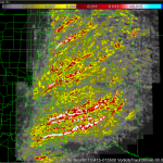
NSSL has released this image documenting the rotation tracks of the devastating tornadoes on April 27-28.
Official websites use .gov
A
.gov website belongs to an official government
organization in the United States.
Secure .gov websites use HTTPS
A
lock (
) or https:// means you’ve safely connected to
the .gov website. Share sensitive information only on official,
secure websites.
NSSL has released this image documenting the rotation tracks of the devastating tornadoes on April 27-28.
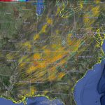
NSSL has released an image documenting the rotation tracks of the devastating tornadoes on April 27-28. Bright reds and yellows show more intense circulations.
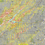
NSSL’s Warning Decision Support System-Integrated Information (WDSS-II) On Demand can be used to help confirm when and where severe weather occurs. The American Red Cross and local NWS forecast offices have used the product for disaster response and recovery, and damage surveys. This image shows rotation tracks across Arkansas from the Monday, April 25 tornado outbreak.
NWS forecasters will be evaluating a new weather-adaptive three-dimensional variational data assimilation (3DVAR) system from NSSL/CIMMS that automatically detects and analyzes supercell thunderstorms during the 2011 Experimental Warning Program in the Hazardous Weather Testbed.

A profile video spotlighting NSSL’s Pam Heinselman has been added to “STEM Stories,” a project to highlight the lives and work of women involved in science, technology, engineering and mathematics (STEM).
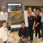
NSSL scientists are preparing to host dozens of researchers, modelers and forecasters from around the world to work side-by-side on improving severe weather forecasts and warnings.