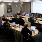
Warn-on-Forecast Week!

Researchers and forecasters talk Warn-on-Forecast

The NOAA NSSL hosted the Technical Workshop on Numerical Guidance Support Warn-on-Forecast on Tuesday February 5.

The fourth annual Warn on Forecast and High Impact Weather Workshop followed on February 6-7.

Warn-on-Forecast http://www.nssl.noaa.gov/projects/wof/collaborators include NSSL and Earth System Research Laboratory, NOAA National Weather Service and Storm Prediction Center, The University of Oklahoma’s Center for the Analysis and Prediction of Storms, and Social Science Woven Into Meteorology.

These workshops give researchers an opportunity to present progress reports and to discuss plans for further research toward improvements in lead time for severe weather warnings.

Share this:

Recent significant papers released online

(OAR National Severe Storms Laboratory and Cooperative Institute for Mesoscale Meteorological Studies) Tornado path length forecasts from 2010 – 2011 using ensemble updraft helicity

Journal:  Weather and Forecasting (Early online release 1/14/13)

Authors:  Adam J. Clark, (CIMMS/NSSL) Jidong Gao,(NSSL) Patrick T. Marsh, (CIMMS/NSSL) Travis Smith, (CIMMS/NSSL) John S. Kain,(NSSL) James Correia, Jr., Ming Xue, and Fanyou Kong

Summary
This paper adds new data to previous research that diagnosed a strong relationship between the cumulative path lengths of simulated rotating storms (measured using a 3-dimensional object identification algorithm applied to forecast updraft helicity) and the cumulative path lengths of tornadoes. The new forecast examples are from three major 2011 tornado outbreaks – 16 and 27 April, and 24 May, as well as two forecast failure cases from June 2010. Finally, analysis updraft helicity from 27 April 2011 is computed using a three-dimensional variational data assimilation system to obtain 1.25 km grid-spacing analyses at 5-minute intervals and compared to forecast UH from individual SSEF members.

Important conclusions:   Forecast updraft helicity pathlengths during the spring could be a very skillfull predictor for the severity of tornado outbreaks as measured by total pathlengths.

Significance:  Efforts continue to find better ways to predict tornadoes and tornado outbreaks  Weather and Forecasting (Early online release 1/14/13)

***********************************************************************

(OAR-National Severe Storms Laboratory) A Unified Flash Flood Database over the US

Journal:  Bulletin of the American Meteorological Society (early online release 1/25/13)

Authors:  Jonathan J. Gourley (NSSL), Yang Hong, Zachary L. Flamig (NSSL), Ami Arthur (NSSL/CIMMS), Robert Clark (NSSL/CIMMS), Martin Calianno, Isabelle Ruin, Terry Ortel, Michael E. Wieczorek, Pierre-Emmanuel Kirstetter (NSSL), Edward Clark, Witold F. Krajewski

Summary:  This study is the first of its kind to assemble, reprocess, describe, and disseminate a georeferenced US database providing a long-term, detailed characterization of flash flooding in terms of spatiotemporal behavior and specificity of impacts. The database is comprised of three primary sources: 1) the entire archive of automated discharge observations from the US Geological Survey that has been reprocessed to describe individual flooding events, 2) flash flooding reports collected by the National Weather Service from 2006-present, and 3) witness reports obtained directly from the public in the Severe Hazards Analysis and Verification Experiment during the summers 2008–2010.

Important conclusions:  A major asset of the unified flash flood database is its collation of relevant information from a variety of sources that is now readily available to the community in common formats.

Significance:  It is anticipated that this database will be used for many diverse purposes such as evaluating tools to predict flash flooding, characterizing seasonal and regional trends, and improving understanding of dominant flood-producing processes.   Bulletin of the American Meteorological Society (early online release 1/25/13)

Authors:  Jonathan J. Gourley (NSSL), Yang Hong, Zachary L. Flamig (NSSL), Ami Arthur (NSSL/CIMMS), Robert Clark (NSSL/CIMMS), Martin Calianno, Isabelle Ruin, Terry Ortel, Michael E. Wieczorek, Pierre-Emmanuel Kirstetter (NSSL), Edward Clark, Witold F. Krajewski

Summary:  This study is the first of its kind to assemble, reprocess, describe, and disseminate a georeferenced US database providing a long-term, detailed characterization of flash flooding in terms of spatiotemporal behavior and specificity of impacts. The database is comprised of three primary sources: 1) the entire archive of automated discharge observations from the US Geological Survey that has been reprocessed to describe individual flooding events, 2) flash flooding reports collected by the National Weather Service from 2006-present, and 3) witness reports obtained directly from the public in the Severe Hazards Analysis and Verification Experiment during the summers 2008–2010.

Important conclusions:  A major asset of the unified flash flood database is its collation of relevant information from a variety of sources that is now readily available to the community in common formats.

Significance:  It is anticipated that this database will be used for many diverse purposes such as evaluating tools to predict flash flooding, characterizing seasonal and regional trends, and improving understanding of dominant flood-producing processes.

Share this:

NSSL unveils re-designed web presence

webpage
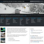
The NOAA National Severe Storms Laboratory has just launched a completely redesigned website to showcase NSSL’s leadership and success in severe weather research.

The site features new content and an improved, easy-to-use structure, taking advantage of current technology that makes updates simpler and also supports smartphones and tablets.  Heavy integration of photos and graphics help tell the NSSL story visually.

The NSSL website now features a rotating header that cycles through the most current research stories.  An easy to use navigation bar lists all main topics and subheadings without having to “mouse-over” them individually.  Content is organized by severe weather research topics and tools targeting both curious public visitors as well as scientists already familiar with NSSL’s work.

A comprehensive search engine points visitors to information quickly and there is now convenient access to fact sheets, multi-media and media resources.

On the footer of every page, visitors can connect to NSSL through social media where interesting pieces of news and photos are posted.

The most visited part of the NSSL site, the education section, now offers a short course in severe weather phenomena written for the generall public called “Severe Weather 101.” There is also a comprehensive list of FAQ’s on each topic, written from emails that are sent to NSSL.  Links to other weather resources, games and activities are featured for educators, students and visitors of all ages.

The NSSL web site is very popular, with more than 4,000 unique visitors every day. This is the first comprehensive update since 2005.

Share this:

NSSL Launches iPhone and Android Apps to collect precipitation reports from the public

Screenshot of the mPING app for iPhone

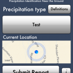
The NOAA National Severe Storms Laboratory (NSSL), in partnership with the University of Oklahoma and has launched an app where users can anonymously report precipitation from their iPhone or Android through the “mobile Precipitation Identification Near the Ground “mPING” app.  NSSL researchers will compare the reports with what radars detect and use the information to develop new radar and forecasting technologies and techniques to determine whether snow, rain, ice pellets, mixtures or hail is falling. NSSL hopes to build a valuable database of tens of thousands of observations from across the U.S.
The apps are available on iTunes or Google Play for use on both phones and tablets.

The reports can be viewed here in real-time:
http://www.nssl.noaa.gov/projects/ping/display/

Learn more at NSSL’s main PING page:  http://www.nssl.noaa.gov/projects/ping/

Link for iTunes mPING app

Link for Android app

Share this: