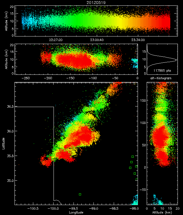
As storms moved across Oklahoma yesterday, the GOES-14 satellite, Multi-function Phased Array Radar (MPAR) and the Oklahoma Lightning Mapping Array (OK-LMA) coordinated data collection for the first time as part of the Super Rapid Scan Experiment.
The goal to of the project is evaluate the potential of these combined observations for forecasting and warning of severe storms.
The GOES-14 satellite has been taken out of storage (currently in orbit over the equator at 105 degrees west) to collect 1-minute satellite imagery over target areas when storms are expected. When thunderstorms move through Oklahoma, MPAR will also scan these storms at a rate of1-minute or less. The LMA’s will map the location and development of of lightning channel segments over the same areas.
The first of the next generation of geostationary satellites (GOES-R), scheduled to be launched in late 2015, will be able to routinely scan at 1-minute frequency with increased spectral and spatial resolution. It will also carry an optical lightning detection system (Geostationary Lightning Mapper) to measure total lightning (in-cloud and cloud-to ground) with high temporal and spatial resolution. The LMA measurements during these tests will be used to help assess the impact of the satellite-based lightning data when it becomes available with GOES-R.
The experiment runs from August 16, 2012 through about October 31, 2012 and is a coordinated effort between NSSL and the NESDIS Office of Satellite and Product Operations, and the NESDIS Center for Satellite Applications and Research (STAR) Advanced Satellite Products Branch in Madison, WI, and the GOES-R program office.
Real-time satellite imagery is being made available on the Web and on workstations (N-AWIPS) at the SPC:
http://cimss.ssec.wisc.edu/goes/srsor/GOES-14_SRSOR.html
http://www.ssec.wisc.edu/~rabin/goes14/loop_srso.html


