

Afternoons in the SFE are composed of three main parts: A Day 2 forecast, evaluations of various aspects of the CAMs, and updates to the morning forecasts. Sometimes, very little new information contributes to these updates, particularly if convection has not initiated by the time of the update. Other days, convective initiation or intensification has occurred, and we have a much better concept of how the convection will evolve. Yesterday was an excellent example of how the afternoon updates can improve upon the morning forecasts, once we get a sense of the evolution.
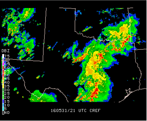
Here’s the reflectivity over Oklahoma and Texas at 1300 UTC, or 0800 CST – the start of operations each morning.
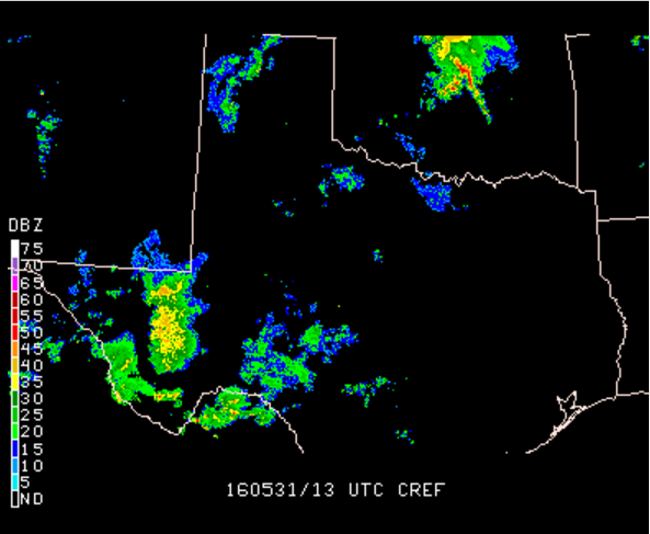
Clearly, we did not have a clean environmental slate to work with, as the ongoing convection in western Texas and central Oklahoma can attest to. In fact, a shelf cloud swept across much of central Oklahoma yesterday, and was visible in Norman as participants were arriving at the testbed. This shelf cloud showed up quite nicely in the visible satellite, as the textured band of convection running southwest-northeast across western Oklahoma.
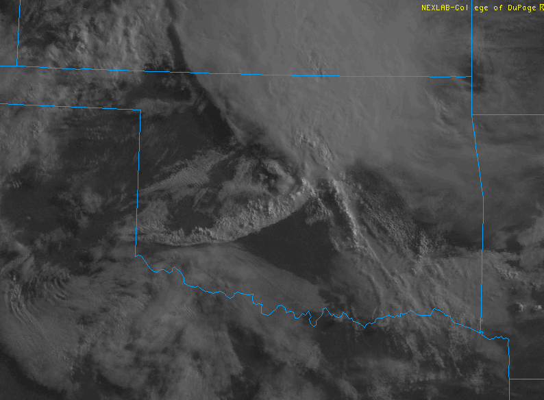
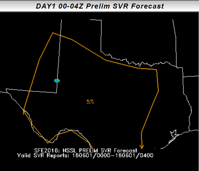
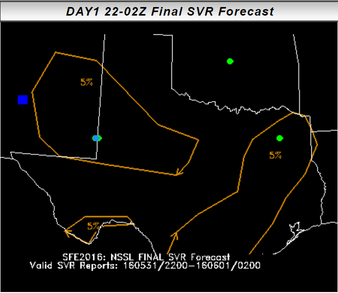
In that satellite image, it’s also clear how many boundaries were laying about yesterday. Outflow boundaries were everywhere, as was a front. At the time pictured above, the front and outflow were roughly co-located, although the outflow pushed further south than the front by the evening. Reacting to models that were quite spread once more (as is typical with such influential mesoscale detail), the total severe desk forecast broad 5% areas in the 22 UTC – 02 UTC period and the 00 UTC – 04 UTC periods:
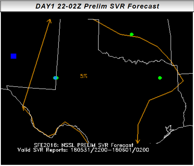
While the magnitudes of these probabilities were appropriately low, there is a lot of false alarm across Texas, which was relatively free of convection during our forecasting time. Our thought was that convection would develop across Texas, but the guidance indicated that convection would progress out of New Mexico toward west Texas, while developing numerous storms that would likely be multicell (as deep layer shear was forecast to be ~30kts) across the middle of Texas.
By the 1500 CST, the radar had evolved considerably:
Storms in New Mexico had initiated, but the bulk of the Texas convection was non-severe, and not moving quickly. After looking at the environment, character of these storms, and the updated HRRR forecasts, the total severe probabilities were able to eliminate a lot of false alarm area – area that was wiped out by the ongoing, non-severe convection.
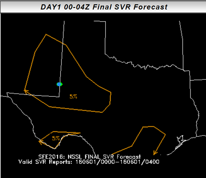
While the probabilities didn’t extend far enough west in the 22 UTC – 02 UTC period, much of Texas was eliminated in the updates. Herein lies the advantage of the afternoon updates – sometimes the question of CI is resolved, and the evolution of convection that was ongoing during the morning forecast becomes more clear.
Even on marginal days, with relatively few reports, we can try to improve our forecasts. Updated HRRR runs, which did quite well last week, are used in conjunction with current observations to determine which morning ensembles were on the right track. Sometimes, our afternoon updates aren’t changed from the morning forecasts. In this case, the FAR decreased. As we’re working in real time, we can only forecast for what the atmosphere gives us. However, even in marginal cases, we try to integrate our meteorological knowledge, observations, and numerical guidance to come up with a coherent, consistent forecast.