
Up up and away!
Official websites use .gov
A
.gov website belongs to an official government
organization in the United States.
Secure .gov websites use HTTPS
A
lock (
) or https:// means you’ve safely connected to
the .gov website. Share sensitive information only on official,
secure websites.
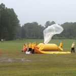
More than 100 researchers from NOAA and 29 other organizations are collaborating on a field project this spring to discover how thunderstorms act like elevators, taking pollution and water-rich air from the surface and lofting it straight up into the upper troposphere.
NSSL co-hosted the Southern Thunder 2011 Workshop at the National Weather Center in Norman, Okla. last week along with the NOAA Storm Prediction Center and the University of Oklahoma.
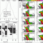
Researchers from NSSL and CIMMS have published the first study to combine rapidly-updating phased array radar data with high-resolution lightning data to study lightning behavior in a hail storm.
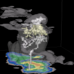
A simulation of a Florida thunderstorm showing two lightning flashes (upper-level intracloud and a negative cloud-to-ground). Light gray is the cloud boundary, darker gray is 35 dBZ reflectivity. 2D color slice is simulated NEXRAD reflectivity.
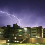
NSSL’s JJ Gourley received first place in the OAR “Research Tools of the Trade” category for his shot of a lightning strike with a VORTEX2 mobile mesonet in the foreground.